
Station XE SOB - Son of Browne
Network: XE99 - Broadband Experiment Across Alaskan Range
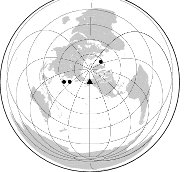
Nearby stations (2 deg radius)
| Station | Name | (Lat, Lon) | Start / End | Elevation |
| SOB | Son of Browne | (64.17, -149.30) | 2000-06-10 / 2001-12-31 | 360 m |
| Crust2 Type: | L8,thin continental arc, Cordilleras, 0.5 km seds. |
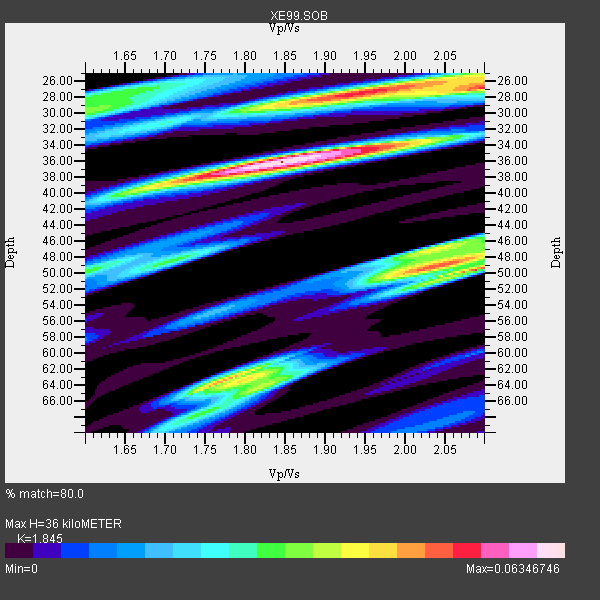
| Thickness Estimate: | 36 km |
| Thickness StdDev: | 14 km |
| Vp/Vs Estimate: | 1.85 |
| Vp/Vs StdDev: | 0.10 |
| Vs Estimate: | 3.559 km/s |
| Poisson's Ratio: | 0.29 |
| Peak Value: | 0.06 |
| Assumed Vp: | 6.566 km/s |
| Ps Weight: | 0.33333334 |
| PpPs Weight: | 0.33333334 |
| PsPs Weight: | 0.33333328 |
| Residual Complexity: | 0.839 |
| Nearby stations H: | +- |
| (2.0 deg) Vp/Vs: | +- |
0 with match > 90% ( 0.0 %) and 3 with match > 80% ( 100.0 %) out of 3.
Download stack as xyz text file.
Azimuth Distribution of Events:
Prior Results for this Station
| Study | Thickness | Vp/Vs | Vp | Vs | Poissons Ratio | Extra |
| EARS | 36 km | 1.85 | 6.566 km/s | 3.559 km/s | 0.29 | |
| Crust2.0 | 34 km | 1.77 | 6.566 km/s | 3.707 km/s | 0.27 | L8,thin continental arc, Cordilleras, 0.5 km seds. |
| Global Maxima | 36 km | 1.85 | 6.566 km/s | 3.559 km/s | 0.29 | amp=0.06346746 |
| Local Maxima 1 | 28 km | 1.94 | 6.566 km/s | 3.389 km/s | 0.32 | amp=0.05219285 |
| Local Maxima 2 | 50 km | 2.09 | 6.566 km/s | 3.145 km/s | 0.35 | amp=0.051109284 |
| Local Maxima 3 | 64 km | 1.77 | 6.566 km/s | 3.715 km/s | 0.26 | amp=0.046926543 |
| Local Maxima 4 | 49 km | 2.04 | 6.566 km/s | 3.227 km/s | 0.34 | amp=0.043043755 |
| Predicted Arrivals for vertical incidence (zero ray parameter) | |
| Ps | 4.63 SECOND |
| PpPs | 15.60 SECOND |
| PsPs/PpSs | 20.23 SECOND |
Events Processed for this Station
Download zip of receiver functions as SAC
Plot maxima for each earthquake.
Events Used in the Stack
(3 events)| Radial Match | Distance | Baz | FERegion | Time | Lat/Lon | Depth | Magnitude |
| 87.61108 | 46.7 deg | 28.262 deg | Iceland | 2000/06/17 15:42:52 GMT | (64.0, -20.6) | 10 km | 5.7 MB |
| 83.47093 | 40.4 deg | 271.081 deg | Kuril Islands | 2000/08/19 17:26:27 GMT | (43.8, 147.2) | 62 km | 6.0 MB, 5.8 MW, 5.7 MW |
| 82.65635 | 51.8 deg | 270.71 deg | Near S. Coast Of Honshu, Japan | 2000/07/01 07:01:55 GMT | (34.2, 139.1) | 10 km | 6.0 MB, 6.1 MS, 6.2 MW, 6.2 MW |
Losers
(0 events)| Radial Match | Distance | Baz | FERegion | Time | Lat/Lon | Depth | Magnitude | Reason |
