
Station XF L03 - XF.L03
Network: XF00 - Laramie Telemetered Brad-band Array
Nearby stations (2 deg radius)
| Station | Name | (Lat, Lon) | Start / End | Elevation |
| L03 | XF.L03 | (41.04, -105.55) | 2000-09-01 / 2002-01-01 | 8050 m |
| Crust2 Type: | P4,orogen/50km, Urals, Tethian Orogen, Rockies 1 km seds. |
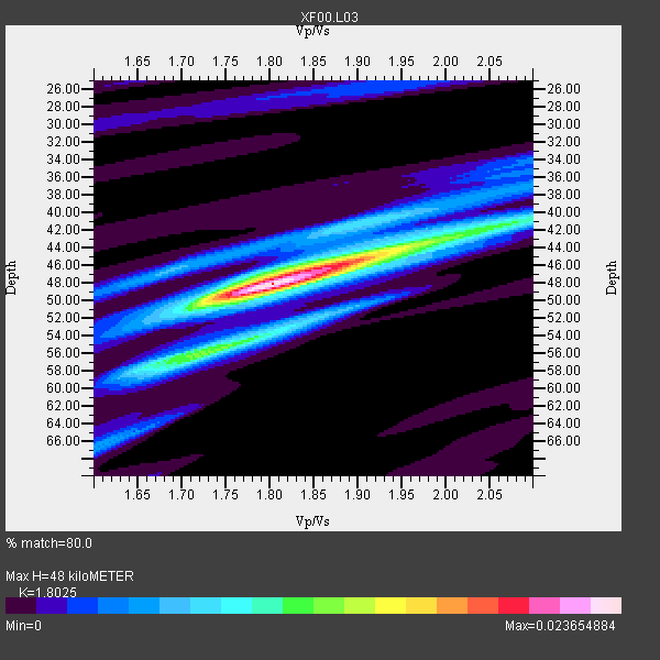
| Thickness Estimate: | 48 km |
| Thickness StdDev: | 2.8 km |
| Vp/Vs Estimate: | 1.80 |
| Vp/Vs StdDev: | 0.06 |
| Vs Estimate: | 3.498 km/s |
| Poisson's Ratio: | 0.28 |
| Peak Value: | 0.02 |
| Assumed Vp: | 6.306 km/s |
| Ps Weight: | 0.33333334 |
| PpPs Weight: | 0.33333334 |
| PsPs Weight: | 0.33333328 |
| Residual Complexity: | 0.572 |
| Nearby stations H: | +- |
| (2.0 deg) Vp/Vs: | +- |
3 with match > 90% ( 33.333332 %) and 9 with match > 80% ( 100.0 %) out of 9.
Download stack as xyz text file.
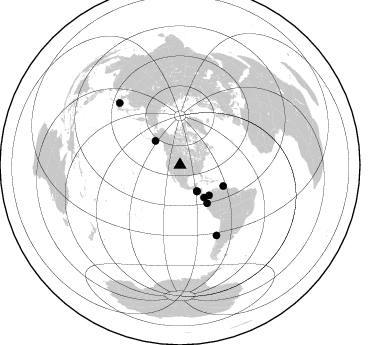
Azimuth Distribution of Events:
Prior Results for this Station
| Study | Thickness | Vp/Vs | Vp | Vs | Poissons Ratio | Extra |
| EARS | 48 km | 1.80 | 6.306 km/s | 3.498 km/s | 0.28 | |
| Crust2.0 | 50 km | 1.76 | 6.306 km/s | 3.584 km/s | 0.26 | P4,orogen/50km, Urals, Tethian Orogen, Rockies 1 km seds. |
| Global Maxima | 48 km | 1.80 | 6.306 km/s | 3.498 km/s | 0.28 | amp=0.023654884 |
| Local Maxima 1 | 45 km | 1.91 | 6.306 km/s | 3.297 km/s | 0.31 | amp=0.013341185 |
| Local Maxima 2 | 41 km | 2.07 | 6.306 km/s | 3.043 km/s | 0.35 | amp=0.008988249 |
| Local Maxima 3 | 55 km | 1.75 | 6.306 km/s | 3.609 km/s | 0.26 | amp=0.0076909238 |
| Local Maxima 4 | 51 km | 1.72 | 6.306 km/s | 3.677 km/s | 0.24 | amp=0.0055899066 |
| Predicted Arrivals for vertical incidence (zero ray parameter) | |
| Ps | 6.11 SECOND |
| PpPs | 21.33 SECOND |
| PsPs/PpSs | 27.44 SECOND |
Events Processed for this Station
Download zip of receiver functions as SAC
Plot maxima for each earthquake.
Events Used in the Stack
(9 events)| Radial Match | Distance | Baz | FERegion | Time | Lat/Lon | Depth | Magnitude |
| 96.54206 | 31.6 deg | 147.245 deg | El Salvador | 2001/01/13 17:33:32 GMT | (13.0, -88.7) | 60 km | 6.4 MB, 7.8 MS, 7.7 MW, 7.5 ME |
| 91.35452 | 79.2 deg | 152.571 deg | Off Coast Of Central Chile | 2001/04/09 09:00:57 GMT | (-32.7, -73.1) | 11 km | 6.1 MB, 6.3 MS, 6.7 MW, 6.3 ME |
| 90.44921 | 46.9 deg | 144.676 deg | Near Coast Of Ecuador | 2000/09/28 23:23:43 GMT | (-0.2, -80.6) | 23 km | 5.8 MB, 6.0 MS, 6.6 MW, 6.4 MW |
| 87.092 | 30.9 deg | 147.217 deg | El Salvador | 2001/02/13 14:22:05 GMT | (13.7, -88.9) | 10 km | 5.5 MB, 6.5 MS, 6.6 MW, 6.1 MD |
| 86.8269 | 41.9 deg | 136.261 deg | Panama-Colombia Border Region | 2000/11/08 06:59:58 GMT | (7.0, -77.8) | 17 km | 6.0 MB, 6.4 MS, 6.5 MW, 6.2 ML |
| 84.81681 | 34.3 deg | 314.244 deg | Kodiak Island Region, Alaska | 2001/01/10 16:02:44 GMT | (57.1, -153.2) | 33 km | 6.2 MB, 6.8 MS, 7.1 MW, 6.8 ML |
| 84.338684 | 86.7 deg | 315.684 deg | Western Honshu, Japan | 2000/10/06 04:30:19 GMT | (35.5, 133.1) | 10 km | 5.8 MB, 6.8 MS, 7.0 ME, 6.7 MW |
| 82.92324 | 48.1 deg | 115.868 deg | Windward Islands | 2000/10/04 14:37:44 GMT | (11.1, -62.6) | 110 km | 5.6 MB, 5.4 MS, 6.1 MW, 5.9 MD |
| 82.526184 | 40.4 deg | 143.402 deg | South Of Panama | 2000/12/12 05:26:45 GMT | (6.0, -82.7) | 10 km | 5.8 MB, 5.7 MS, 6.3 ME, 6.1 MW |
Losers
(0 events)| Radial Match | Distance | Baz | FERegion | Time | Lat/Lon | Depth | Magnitude | Reason |
