
Station XF L05 - XF.L05
Network: XF00 - Laramie Telemetered Brad-band Array
Nearby stations (2 deg radius)
| Station | Name | (Lat, Lon) | Start / End | Elevation |
| L05 | XF.L05 | (41.08, -105.59) | 2000-09-01 / 2002-01-01 | 1.8 m |
| Crust2 Type: | P4,orogen/50km, Urals, Tethian Orogen, Rockies 1 km seds. |
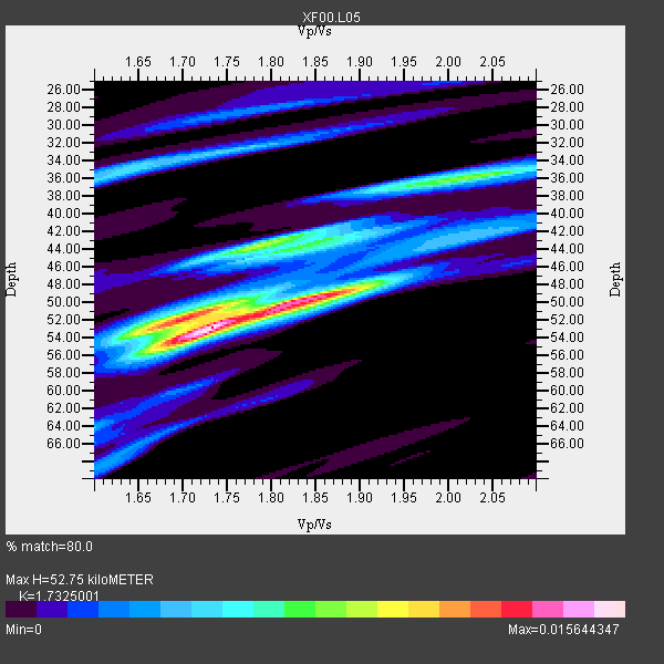
| Thickness Estimate: | 53 km |
| Thickness StdDev: | 5.8 km |
| Vp/Vs Estimate: | 1.73 |
| Vp/Vs StdDev: | 0.12 |
| Vs Estimate: | 3.64 km/s |
| Poisson's Ratio: | 0.25 |
| Peak Value: | 0.02 |
| Assumed Vp: | 6.306 km/s |
| Ps Weight: | 0.33333334 |
| PpPs Weight: | 0.33333334 |
| PsPs Weight: | 0.33333328 |
| Residual Complexity: | 0.710 |
| Nearby stations H: | +- |
| (2.0 deg) Vp/Vs: | +- |
2 with match > 90% ( 25.0 %) and 8 with match > 80% ( 100.0 %) out of 8.
Download stack as xyz text file.
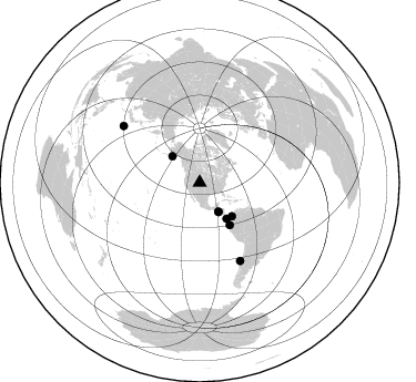
Azimuth Distribution of Events:
Prior Results for this Station
| Study | Thickness | Vp/Vs | Vp | Vs | Poissons Ratio | Extra |
| EARS | 53 km | 1.73 | 6.306 km/s | 3.64 km/s | 0.25 | |
| Crust2.0 | 50 km | 1.76 | 6.306 km/s | 3.584 km/s | 0.26 | P4,orogen/50km, Urals, Tethian Orogen, Rockies 1 km seds. |
| Global Maxima | 53 km | 1.73 | 6.306 km/s | 3.64 km/s | 0.25 | amp=0.015644347 |
| Local Maxima 1 | 49 km | 1.86 | 6.306 km/s | 3.399 km/s | 0.30 | amp=0.0117464615 |
| Local Maxima 2 | 44 km | 1.79 | 6.306 km/s | 3.533 km/s | 0.27 | amp=0.009448014 |
| Local Maxima 3 | 36 km | 2.03 | 6.306 km/s | 3.11 km/s | 0.34 | amp=0.008173307 |
| Local Maxima 4 | 51 km | 1.72 | 6.306 km/s | 3.672 km/s | 0.24 | amp=0.006929046 |
| Predicted Arrivals for vertical incidence (zero ray parameter) | |
| Ps | 6.13 SECOND |
| PpPs | 22.86 SECOND |
| PsPs/PpSs | 28.98 SECOND |
Events Processed for this Station
Download zip of receiver functions as SAC
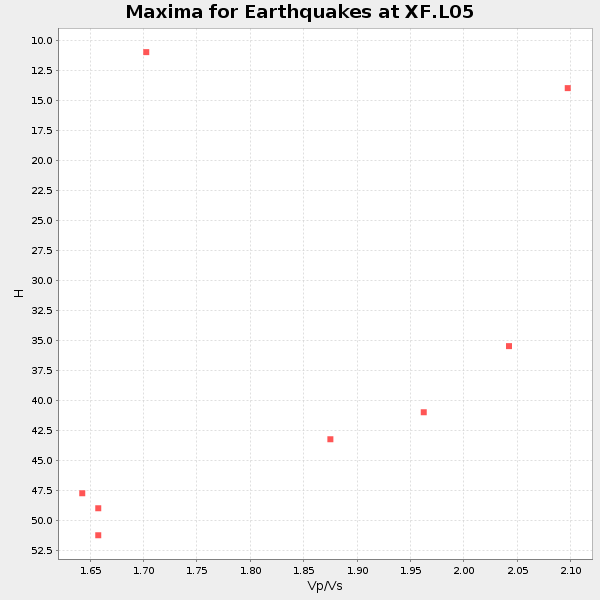
Plot maxima for each earthquake.
Events Used in the Stack
(8 events)| Radial Match | Distance | Baz | FERegion | Time | Lat/Lon | Depth | Magnitude |
| 96.95526 | 31.6 deg | 147.224 deg | El Salvador | 2001/01/13 17:33:32 GMT | (13.0, -88.7) | 60 km | 6.4 MB, 7.8 MS, 7.7 MW, 7.5 ME |
| 95.139336 | 79.3 deg | 152.549 deg | Off Coast Of Central Chile | 2001/04/09 09:00:57 GMT | (-32.7, -73.1) | 11 km | 6.1 MB, 6.3 MS, 6.7 MW, 6.3 ME |
| 87.81593 | 85.7 deg | 306.67 deg | Southeast Of Honshu, Japan | 2001/04/14 23:27:26 GMT | (30.1, 141.8) | 10 km | 6.0 MB, 5.8 MS, 6.0 MW, 6.0 ME |
| 86.86619 | 46.9 deg | 144.658 deg | Near Coast Of Ecuador | 2000/09/28 23:23:43 GMT | (-0.2, -80.6) | 23 km | 5.8 MB, 6.0 MS, 6.6 MW, 6.4 MW |
| 86.36666 | 34.2 deg | 314.206 deg | Kodiak Island Region, Alaska | 2001/01/10 16:02:44 GMT | (57.1, -153.2) | 33 km | 6.2 MB, 6.8 MS, 7.1 MW, 6.8 ML |
| 85.253044 | 40.5 deg | 143.385 deg | South Of Panama | 2000/12/12 05:26:45 GMT | (6.0, -82.7) | 10 km | 5.8 MB, 5.7 MS, 6.3 ME, 6.1 MW |
| 82.27422 | 30.9 deg | 147.196 deg | El Salvador | 2001/02/13 14:22:05 GMT | (13.7, -88.9) | 10 km | 5.5 MB, 6.5 MS, 6.6 MW, 6.1 MD |
| 82.11829 | 42.0 deg | 136.25 deg | Panama-Colombia Border Region | 2000/11/08 06:59:58 GMT | (7.0, -77.8) | 17 km | 6.0 MB, 6.4 MS, 6.5 MW, 6.2 ML |
Losers
(0 events)| Radial Match | Distance | Baz | FERegion | Time | Lat/Lon | Depth | Magnitude | Reason |
