
Station XF L09 - XF.L09
Network: XF00 - Laramie Telemetered Brad-band Array
Nearby stations (2 deg radius)
| Station | Name | (Lat, Lon) | Start / End | Elevation |
| L09 | XF.L09 | (41.16, -105.66) | 2000-09-01 / 2002-01-01 | 1.8 m |
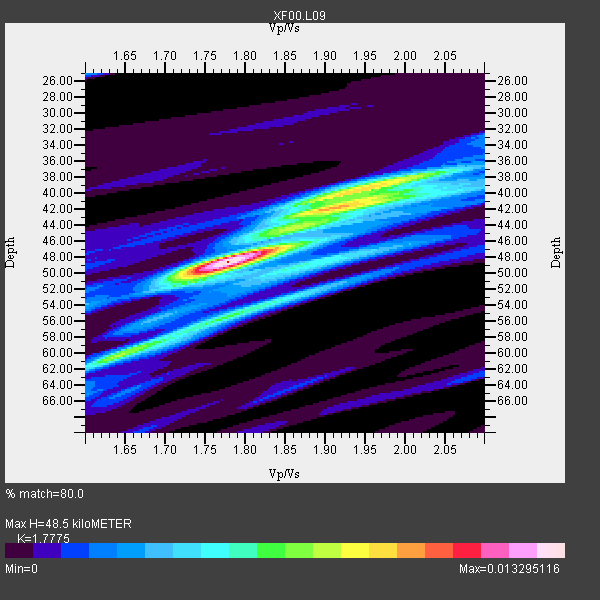
| Crust2 Type: | P4,orogen/50km, Urals, Tethian Orogen, Rockies 1 km seds. |
| Thickness Estimate: | 48 km |
| Thickness StdDev: | 7.2 km |
| Vp/Vs Estimate: | 1.78 |
| Vp/Vs StdDev: | 0.11 |
| Vs Estimate: | 3.548 km/s |
| Poisson's Ratio: | 0.27 |
| Peak Value: | 0.01 |
| Assumed Vp: | 6.306 km/s |
| Ps Weight: | 0.33333334 |
| PpPs Weight: | 0.33333334 |
| PsPs Weight: | 0.33333328 |
| Residual Complexity: | 0.684 |
| Nearby stations H: | +- |
| (2.0 deg) Vp/Vs: | +- |
4 with match > 90% ( 44.444443 %) and 9 with match > 80% ( 100.0 %) out of 9.
Download stack as xyz text file.
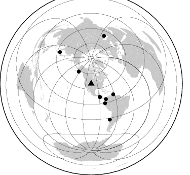
Azimuth Distribution of Events:
Prior Results for this Station
| Study | Thickness | Vp/Vs | Vp | Vs | Poissons Ratio | Extra |
| EARS | 48 km | 1.78 | 6.306 km/s | 3.548 km/s | 0.27 | |
| Crust2.0 | 50 km | 1.76 | 6.306 km/s | 3.584 km/s | 0.26 | P4,orogen/50km, Urals, Tethian Orogen, Rockies 1 km seds. |
| Global Maxima | 48 km | 1.78 | 6.306 km/s | 3.548 km/s | 0.27 | amp=0.013295116 |
| Local Maxima 1 | 42 km | 1.92 | 6.306 km/s | 3.276 km/s | 0.32 | amp=0.008051009 |
| Local Maxima 2 | 55 km | 1.78 | 6.306 km/s | 3.543 km/s | 0.27 | amp=0.006059404 |
| Local Maxima 3 | 39 km | 1.95 | 6.306 km/s | 3.234 km/s | 0.32 | amp=0.0051177163 |
| Local Maxima 4 | 59 km | 1.68 | 6.306 km/s | 3.748 km/s | 0.23 | amp=0.004378822 |
| Predicted Arrivals for vertical incidence (zero ray parameter) | |
| Ps | 5.98 SECOND |
| PpPs | 21.36 SECOND |
| PsPs/PpSs | 27.34 SECOND |
Events Processed for this Station
Download zip of receiver functions as SAC
Plot maxima for each earthquake.
Events Used in the Stack
(9 events)| Radial Match | Distance | Baz | FERegion | Time | Lat/Lon | Depth | Magnitude |
| 95.43325 | 31.7 deg | 147.177 deg | El Salvador | 2001/01/13 17:33:32 GMT | (13.0, -88.7) | 60 km | 6.4 MB, 7.8 MS, 7.7 MW, 7.5 ME |
| 93.76905 | 47.0 deg | 144.615 deg | Near Coast Of Ecuador | 2000/09/28 23:23:43 GMT | (-0.2, -80.6) | 23 km | 5.8 MB, 6.0 MS, 6.6 MW, 6.4 MW |
| 92.15124 | 79.4 deg | 152.502 deg | Off Coast Of Central Chile | 2001/04/09 09:00:57 GMT | (-32.7, -73.1) | 11 km | 6.1 MB, 6.3 MS, 6.7 MW, 6.3 ME |
| 90.84214 | 97.7 deg | 15.126 deg | Turkmenistan | 2000/12/06 17:11:06 GMT | (39.6, 54.8) | 30 km | 6.7 MB, 7.5 MS, 7.0 MW, 6.9 ME |
| 89.23721 | 42.0 deg | 136.223 deg | Panama-Colombia Border Region | 2000/11/08 06:59:58 GMT | (7.0, -77.8) | 17 km | 6.0 MB, 6.4 MS, 6.5 MW, 6.2 ML |
| 85.772415 | 31.0 deg | 147.149 deg | El Salvador | 2001/02/13 14:22:05 GMT | (13.7, -88.9) | 10 km | 5.5 MB, 6.5 MS, 6.6 MW, 6.1 MD |
| 84.20928 | 34.2 deg | 314.131 deg | Kodiak Island Region, Alaska | 2001/01/10 16:02:44 GMT | (57.1, -153.2) | 33 km | 6.2 MB, 6.8 MS, 7.1 MW, 6.8 ML |
| 81.801926 | 48.2 deg | 115.867 deg | Windward Islands | 2000/10/04 14:37:44 GMT | (11.1, -62.6) | 110 km | 5.6 MB, 5.4 MS, 6.1 MW, 5.9 MD |
| 81.80179 | 88.0 deg | 315.114 deg | Western Honshu, Japan | 2001/03/24 06:27:53 GMT | (34.1, 132.5) | 50 km | 6.4 MB, 6.5 MS, 6.8 MW, 6.4 ME |
Losers
(0 events)| Radial Match | Distance | Baz | FERegion | Time | Lat/Lon | Depth | Magnitude | Reason |
