
Station XF L12 - XF.L12
Network: XF00 - Laramie Telemetered Brad-band Array
Nearby stations (2 deg radius)
| Station | Name | (Lat, Lon) | Start / End | Elevation |
| L12 | XF.L12 | (41.22, -105.71) | 2000-09-01 / 2002-01-01 | 7250 m |
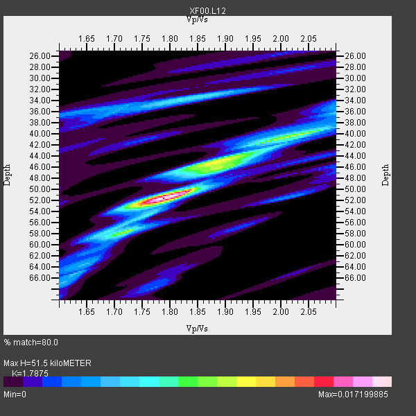
| Crust2 Type: | P4,orogen/50km, Urals, Tethian Orogen, Rockies 1 km seds. |
| Thickness Estimate: | 52 km |
| Thickness StdDev: | 8.7 km |
| Vp/Vs Estimate: | 1.79 |
| Vp/Vs StdDev: | 0.15 |
| Vs Estimate: | 3.528 km/s |
| Poisson's Ratio: | 0.27 |
| Peak Value: | 0.02 |
| Assumed Vp: | 6.306 km/s |
| Ps Weight: | 0.33333334 |
| PpPs Weight: | 0.33333334 |
| PsPs Weight: | 0.33333328 |
| Residual Complexity: | 0.590 |
| Nearby stations H: | +- |
| (2.0 deg) Vp/Vs: | +- |
1 with match > 90% ( 20.0 %) and 5 with match > 80% ( 100.0 %) out of 5.
Download stack as xyz text file.
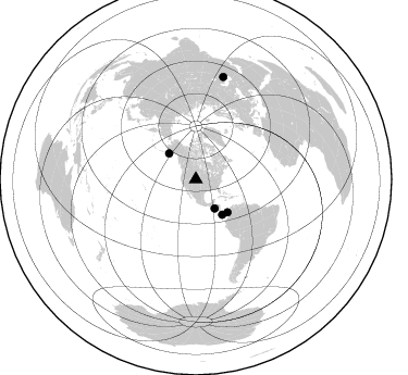
Azimuth Distribution of Events:
Prior Results for this Station
| Study | Thickness | Vp/Vs | Vp | Vs | Poissons Ratio | Extra |
| EARS | 52 km | 1.79 | 6.306 km/s | 3.528 km/s | 0.27 | |
| Crust2.0 | 50 km | 1.76 | 6.306 km/s | 3.584 km/s | 0.26 | P4,orogen/50km, Urals, Tethian Orogen, Rockies 1 km seds. |
| Global Maxima | 52 km | 1.79 | 6.306 km/s | 3.528 km/s | 0.27 | amp=0.017199885 |
| Local Maxima 1 | 40 km | 2.05 | 6.306 km/s | 3.08 km/s | 0.34 | amp=0.008590202 |
| Local Maxima 2 | 45 km | 1.88 | 6.306 km/s | 3.359 km/s | 0.30 | amp=0.007274808 |
| Local Maxima 3 | 34 km | 1.82 | 6.306 km/s | 3.47 km/s | 0.28 | amp=0.006063828 |
| Local Maxima 4 | 58 km | 1.72 | 6.306 km/s | 3.661 km/s | 0.25 | amp=0.00581774 |
| Predicted Arrivals for vertical incidence (zero ray parameter) | |
| Ps | 6.43 SECOND |
| PpPs | 22.77 SECOND |
| PsPs/PpSs | 29.20 SECOND |
Events Processed for this Station
Download zip of receiver functions as SAC
Plot maxima for each earthquake.
Events Used in the Stack
(5 events)| Radial Match | Distance | Baz | FERegion | Time | Lat/Lon | Depth | Magnitude |
| 95.62734 | 31.8 deg | 147.148 deg | El Salvador | 2001/01/13 17:33:32 GMT | (13.0, -88.7) | 60 km | 6.4 MB, 7.8 MS, 7.7 MW, 7.5 ME |
| 86.97627 | 42.1 deg | 136.208 deg | Panama-Colombia Border Region | 2000/11/08 06:59:58 GMT | (7.0, -77.8) | 17 km | 6.0 MB, 6.4 MS, 6.5 MW, 6.2 ML |
| 84.86758 | 97.7 deg | 15.087 deg | Turkmenistan | 2000/12/06 17:11:06 GMT | (39.6, 54.8) | 30 km | 6.7 MB, 7.5 MS, 7.0 MW, 6.9 ME |
| 82.507866 | 40.6 deg | 143.322 deg | South Of Panama | 2000/12/12 05:26:45 GMT | (6.0, -82.7) | 10 km | 5.8 MB, 5.7 MS, 6.3 ME, 6.1 MW |
| 81.363914 | 34.1 deg | 314.071 deg | Kodiak Island Region, Alaska | 2001/01/10 16:02:44 GMT | (57.1, -153.2) | 33 km | 6.2 MB, 6.8 MS, 7.1 MW, 6.8 ML |
Losers
(0 events)| Radial Match | Distance | Baz | FERegion | Time | Lat/Lon | Depth | Magnitude | Reason |
