
Station XF L13 - XF.L13
Network: XF00 - Laramie Telemetered Brad-band Array
Nearby stations (2 deg radius)
| Station | Name | (Lat, Lon) | Start / End | Elevation |
| L13 | XF.L13 | (41.23, -105.73) | 2000-09-01 / 2002-01-01 | 7280 m |
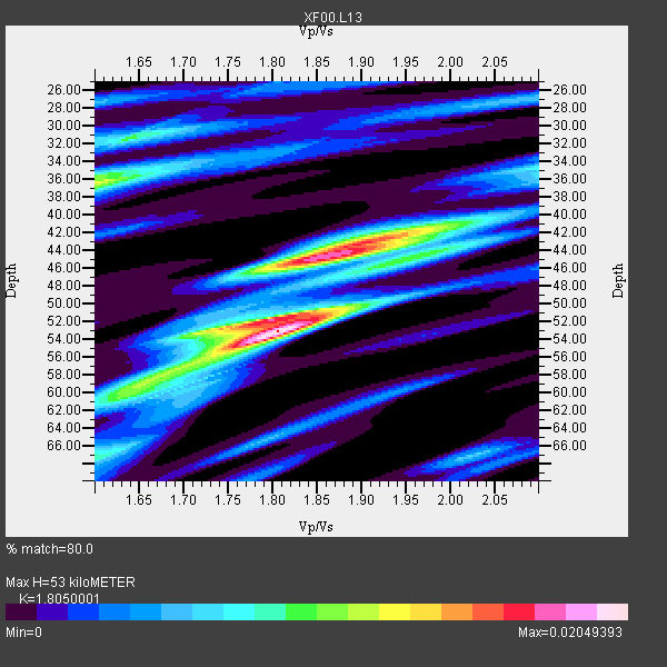
| Crust2 Type: | P4,orogen/50km, Urals, Tethian Orogen, Rockies 1 km seds. |
| Thickness Estimate: | 53 km |
| Thickness StdDev: | 7.6 km |
| Vp/Vs Estimate: | 1.81 |
| Vp/Vs StdDev: | 0.10 |
| Vs Estimate: | 3.494 km/s |
| Poisson's Ratio: | 0.28 |
| Peak Value: | 0.02 |
| Assumed Vp: | 6.306 km/s |
| Ps Weight: | 0.33333334 |
| PpPs Weight: | 0.33333334 |
| PsPs Weight: | 0.33333328 |
| Residual Complexity: | 0.782 |
| Nearby stations H: | +- |
| (2.0 deg) Vp/Vs: | +- |
3 with match > 90% ( 37.5 %) and 8 with match > 80% ( 100.0 %) out of 8.
Download stack as xyz text file.
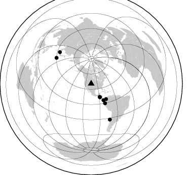
Azimuth Distribution of Events:
Prior Results for this Station
| Study | Thickness | Vp/Vs | Vp | Vs | Poissons Ratio | Extra |
| EARS | 53 km | 1.81 | 6.306 km/s | 3.494 km/s | 0.28 | |
| Crust2.0 | 50 km | 1.76 | 6.306 km/s | 3.584 km/s | 0.26 | P4,orogen/50km, Urals, Tethian Orogen, Rockies 1 km seds. |
| Global Maxima | 53 km | 1.81 | 6.306 km/s | 3.494 km/s | 0.28 | amp=0.02049393 |
| Local Maxima 1 | 44 km | 1.86 | 6.306 km/s | 3.39 km/s | 0.30 | amp=0.018050017 |
| Local Maxima 2 | 36 km | 1.60 | 6.306 km/s | 3.941 km/s | 0.18 | amp=0.013314509 |
| Local Maxima 3 | 52 km | 1.80 | 6.306 km/s | 3.513 km/s | 0.27 | amp=0.011747701 |
| Local Maxima 4 | 59 km | 1.65 | 6.306 km/s | 3.822 km/s | 0.21 | amp=0.010325702 |
| Predicted Arrivals for vertical incidence (zero ray parameter) | |
| Ps | 6.77 SECOND |
| PpPs | 23.58 SECOND |
| PsPs/PpSs | 30.34 SECOND |
Events Processed for this Station
Download zip of receiver functions as SAC
Plot maxima for each earthquake.
Events Used in the Stack
(8 events)| Radial Match | Distance | Baz | FERegion | Time | Lat/Lon | Depth | Magnitude |
| 95.736435 | 31.8 deg | 147.12 deg | El Salvador | 2001/01/13 17:33:32 GMT | (13.0, -88.7) | 60 km | 6.4 MB, 7.8 MS, 7.7 MW, 7.5 ME |
| 92.48848 | 79.5 deg | 152.452 deg | Off Coast Of Central Chile | 2001/04/09 09:00:57 GMT | (-32.7, -73.1) | 11 km | 6.1 MB, 6.3 MS, 6.7 MW, 6.3 ME |
| 91.44202 | 47.1 deg | 144.566 deg | Near Coast Of Ecuador | 2000/09/28 23:23:43 GMT | (-0.2, -80.6) | 23 km | 5.8 MB, 6.0 MS, 6.6 MW, 6.4 MW |
| 89.825424 | 42.1 deg | 136.189 deg | Panama-Colombia Border Region | 2000/11/08 06:59:58 GMT | (7.0, -77.8) | 17 km | 6.0 MB, 6.4 MS, 6.5 MW, 6.2 ML |
| 86.53955 | 85.6 deg | 306.573 deg | Southeast Of Honshu, Japan | 2001/04/14 23:27:26 GMT | (30.1, 141.8) | 10 km | 6.0 MB, 5.8 MS, 6.0 MW, 6.0 ME |
| 85.64629 | 40.7 deg | 143.299 deg | South Of Panama | 2000/12/12 05:26:45 GMT | (6.0, -82.7) | 10 km | 5.8 MB, 5.7 MS, 6.3 ME, 6.1 MW |
| 84.843895 | 31.1 deg | 147.092 deg | El Salvador | 2001/02/13 14:22:05 GMT | (13.7, -88.9) | 10 km | 5.5 MB, 6.5 MS, 6.6 MW, 6.1 MD |
| 83.50424 | 87.9 deg | 315.066 deg | Western Honshu, Japan | 2001/03/24 06:27:53 GMT | (34.1, 132.5) | 50 km | 6.4 MB, 6.5 MS, 6.8 MW, 6.4 ME |
Losers
(0 events)| Radial Match | Distance | Baz | FERegion | Time | Lat/Lon | Depth | Magnitude | Reason |
