
Station XF L16 - XF.L16
Network: XF00 - Laramie Telemetered Brad-band Array
Nearby stations (2 deg radius)
| Station | Name | (Lat, Lon) | Start / End | Elevation |
| L16 | XF.L16 | (41.29, -105.79) | 2000-09-01 / 2002-01-01 | 1.8 m |
| Crust2 Type: | P4,orogen/50km, Urals, Tethian Orogen, Rockies 1 km seds. |
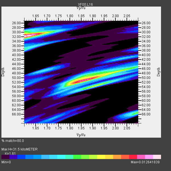
| Thickness Estimate: | 32 km |
| Thickness StdDev: | 9.8 km |
| Vp/Vs Estimate: | 1.61 |
| Vp/Vs StdDev: | 0.14 |
| Vs Estimate: | 3.917 km/s |
| Poisson's Ratio: | 0.19 |
| Peak Value: | 0.01 |
| Assumed Vp: | 6.306 km/s |
| Ps Weight: | 0.33333334 |
| PpPs Weight: | 0.33333334 |
| PsPs Weight: | 0.33333328 |
| Residual Complexity: | 0.874 |
| Nearby stations H: | +- |
| (2.0 deg) Vp/Vs: | +- |
4 with match > 90% ( 40.0 %) and 10 with match > 80% ( 100.0 %) out of 10.
Download stack as xyz text file.
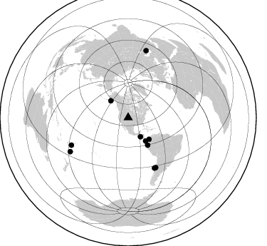
Azimuth Distribution of Events:
Prior Results for this Station
| Study | Thickness | Vp/Vs | Vp | Vs | Poissons Ratio | Extra |
| EARS | 32 km | 1.61 | 6.306 km/s | 3.917 km/s | 0.19 | |
| Crust2.0 | 50 km | 1.76 | 6.306 km/s | 3.584 km/s | 0.26 | P4,orogen/50km, Urals, Tethian Orogen, Rockies 1 km seds. |
| Global Maxima | 32 km | 1.61 | 6.306 km/s | 3.917 km/s | 0.19 | amp=0.012641839 |
| Local Maxima 1 | 51 km | 1.86 | 6.306 km/s | 3.386 km/s | 0.30 | amp=0.011235479 |
| Local Maxima 2 | 53 km | 1.92 | 6.306 km/s | 3.289 km/s | 0.31 | amp=0.00801669 |
| Local Maxima 3 | 65 km | 2.10 | 6.306 km/s | 3.01 km/s | 0.35 | amp=0.0067334403 |
| Local Maxima 4 | 37 km | 1.60 | 6.306 km/s | 3.941 km/s | 0.18 | amp=0.0058674463 |
| Predicted Arrivals for vertical incidence (zero ray parameter) | |
| Ps | 3.05 SECOND |
| PpPs | 13.04 SECOND |
| PsPs/PpSs | 16.08 SECOND |
Events Processed for this Station
Download zip of receiver functions as SAC
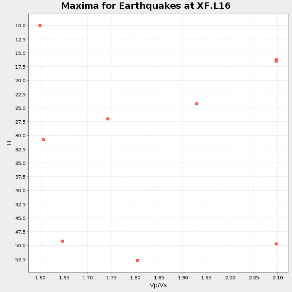
Plot maxima for each earthquake.
Events Used in the Stack
(10 events)| Radial Match | Distance | Baz | FERegion | Time | Lat/Lon | Depth | Magnitude |
| 100.0 | 94.1 deg | 239.705 deg | South Of Fiji Islands | 2001/03/11 00:50:40 GMT | (-25.4, -178.0) | 231 km | 5.5 MB, 5.8 MW, 5.8 MW |
| 93.91215 | 31.9 deg | 147.071 deg | El Salvador | 2001/01/13 17:33:32 GMT | (13.0, -88.7) | 60 km | 6.4 MB, 7.8 MS, 7.7 MW, 7.5 ME |
| 92.436104 | 79.5 deg | 152.41 deg | Off Coast Of Central Chile | 2001/04/09 09:00:57 GMT | (-32.7, -73.1) | 11 km | 6.1 MB, 6.3 MS, 6.7 MW, 6.3 ME |
| 92.14424 | 42.2 deg | 136.158 deg | Panama-Colombia Border Region | 2000/11/08 06:59:58 GMT | (7.0, -77.8) | 17 km | 6.0 MB, 6.4 MS, 6.5 MW, 6.2 ML |
| 89.038086 | 47.2 deg | 144.524 deg | Near Coast Of Ecuador | 2000/09/28 23:23:43 GMT | (-0.2, -80.6) | 23 km | 5.8 MB, 6.0 MS, 6.6 MW, 6.4 MW |
| 87.214134 | 40.7 deg | 143.258 deg | South Of Panama | 2000/12/12 05:26:45 GMT | (6.0, -82.7) | 10 km | 5.8 MB, 5.7 MS, 6.3 ME, 6.1 MW |
| 84.18574 | 88.3 deg | 244.246 deg | Fiji Islands Region | 2001/04/28 04:49:53 GMT | (-18.1, -176.9) | 352 km | 6.2 MB, 6.8 MW, 6.8 MW |
| 83.66094 | 97.6 deg | 15.022 deg | Turkmenistan | 2000/12/06 17:11:06 GMT | (39.6, 54.8) | 30 km | 6.7 MB, 7.5 MS, 7.0 MW, 6.9 ME |
| 82.56203 | 34.0 deg | 314.006 deg | Kodiak Island Region, Alaska | 2001/01/10 16:02:44 GMT | (57.1, -153.2) | 33 km | 6.2 MB, 6.8 MS, 7.1 MW, 6.8 ML |
| 80.69673 | 79.8 deg | 151.003 deg | Near Coast Of Central Chile | 2001/03/15 13:02:42 GMT | (-32.3, -71.5) | 37 km | 6.1 MB, 5.6 MS, 6.0 MW, 5.4 MD |
Losers
(0 events)| Radial Match | Distance | Baz | FERegion | Time | Lat/Lon | Depth | Magnitude | Reason |
