
Station XF L18 - XF.L18
Network: XF00 - Laramie Telemetered Brad-band Array
Nearby stations (2 deg radius)
| Station | Name | (Lat, Lon) | Start / End | Elevation |
| L18 | XF.L18 | (41.33, -105.81) | 2000-09-01 / 2002-01-01 | 7540 m |
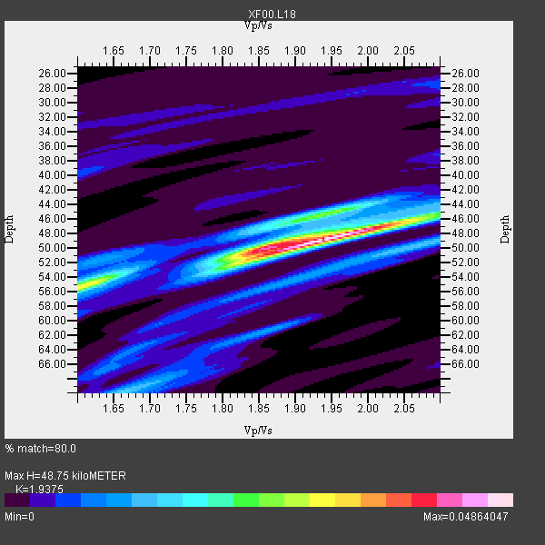
| Crust2 Type: | P4,orogen/50km, Urals, Tethian Orogen, Rockies 1 km seds. |
| Thickness Estimate: | 49 km |
| Thickness StdDev: | 2.8 km |
| Vp/Vs Estimate: | 1.94 |
| Vp/Vs StdDev: | 0.05 |
| Vs Estimate: | 3.255 km/s |
| Poisson's Ratio: | 0.32 |
| Peak Value: | 0.05 |
| Assumed Vp: | 6.306 km/s |
| Ps Weight: | 0.33333334 |
| PpPs Weight: | 0.33333334 |
| PsPs Weight: | 0.33333328 |
| Residual Complexity: | 0.590 |
| Nearby stations H: | 52 km +- 4.2 km |
| (2.0 deg) Vp/Vs: | 1.85 +- 0.13 |
1 with match > 90% ( 20.0 %) and 5 with match > 80% ( 100.0 %) out of 5.
Download stack as xyz text file.
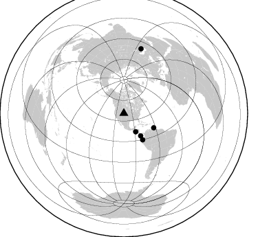
Azimuth Distribution of Events:
Prior Results for this Station
| Study | Thickness | Vp/Vs | Vp | Vs | Poissons Ratio | Extra |
| EARS | 49 km | 1.94 | 6.306 km/s | 3.255 km/s | 0.32 | |
| Crust2.0 | 50 km | 1.76 | 6.306 km/s | 3.584 km/s | 0.26 | P4,orogen/50km, Urals, Tethian Orogen, Rockies 1 km seds. |
| Global Maxima | 49 km | 1.94 | 6.306 km/s | 3.255 km/s | 0.32 | amp=0.04864047 |
| Local Maxima 1 | 50 km | 1.85 | 6.306 km/s | 3.404 km/s | 0.29 | amp=0.024666427 |
| Local Maxima 2 | 56 km | 1.60 | 6.306 km/s | 3.935 km/s | 0.18 | amp=0.019324845 |
| Local Maxima 3 | 45 km | 1.94 | 6.306 km/s | 3.255 km/s | 0.32 | amp=0.018361278 |
| Local Maxima 4 | 46 km | 2.08 | 6.306 km/s | 3.035 km/s | 0.35 | amp=0.01739174 |
| Predicted Arrivals for vertical incidence (zero ray parameter) | |
| Ps | 7.25 SECOND |
| PpPs | 22.71 SECOND |
| PsPs/PpSs | 29.96 SECOND |
Events Processed for this Station
Download zip of receiver functions as SAC
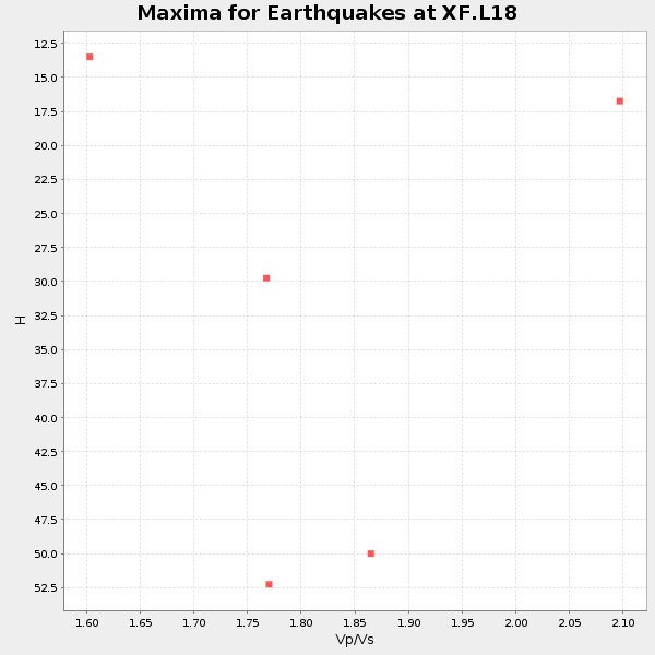
Plot maxima for each earthquake.
Events Used in the Stack
(5 events)| Radial Match | Distance | Baz | FERegion | Time | Lat/Lon | Depth | Magnitude |
| 93.067184 | 31.9 deg | 147.075 deg | El Salvador | 2001/01/13 17:33:32 GMT | (13.0, -88.7) | 60 km | 6.4 MB, 7.8 MS, 7.7 MW, 7.5 ME |
| 82.94135 | 97.6 deg | 15.008 deg | Turkmenistan | 2000/12/06 17:11:06 GMT | (39.6, 54.8) | 30 km | 6.7 MB, 7.5 MS, 7.0 MW, 6.9 ME |
| 82.80869 | 40.8 deg | 143.261 deg | South Of Panama | 2000/12/12 05:26:45 GMT | (6.0, -82.7) | 10 km | 5.8 MB, 5.7 MS, 6.3 ME, 6.1 MW |
| 81.58888 | 47.2 deg | 144.523 deg | Near Coast Of Ecuador | 2000/09/28 23:23:43 GMT | (-0.2, -80.6) | 23 km | 5.8 MB, 6.0 MS, 6.6 MW, 6.4 MW |
| 80.91259 | 48.4 deg | 115.862 deg | Windward Islands | 2000/10/04 14:37:44 GMT | (11.1, -62.6) | 110 km | 5.6 MB, 5.4 MS, 6.1 MW, 5.9 MD |
Losers
(0 events)| Radial Match | Distance | Baz | FERegion | Time | Lat/Lon | Depth | Magnitude | Reason |
