
Station XF L19 - XF.L19
Network: XF00 - Laramie Telemetered Brad-band Array
Nearby stations (2 deg radius)
| Station | Name | (Lat, Lon) | Start / End | Elevation |
| L19 | XF.L19 | (41.36, -105.83) | 2000-09-01 / 2002-01-01 | 7260 m |
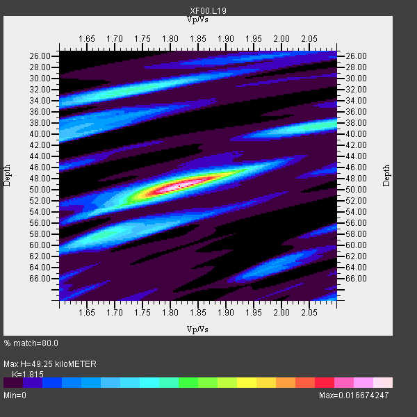
| Crust2 Type: | P4,orogen/50km, Urals, Tethian Orogen, Rockies 1 km seds. |
| Thickness Estimate: | 49 km |
| Thickness StdDev: | 5.5 km |
| Vp/Vs Estimate: | 1.82 |
| Vp/Vs StdDev: | 0.09 |
| Vs Estimate: | 3.474 km/s |
| Poisson's Ratio: | 0.28 |
| Peak Value: | 0.02 |
| Assumed Vp: | 6.306 km/s |
| Ps Weight: | 0.33333334 |
| PpPs Weight: | 0.33333334 |
| PsPs Weight: | 0.33333328 |
| Residual Complexity: | 0.610 |
| Nearby stations H: | +- |
| (2.0 deg) Vp/Vs: | +- |
3 with match > 90% ( 33.333332 %) and 9 with match > 80% ( 100.0 %) out of 9.
Download stack as xyz text file.
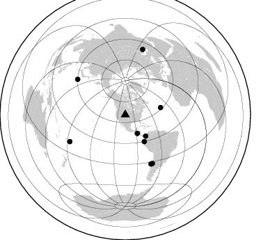
Azimuth Distribution of Events:
Prior Results for this Station
| Study | Thickness | Vp/Vs | Vp | Vs | Poissons Ratio | Extra |
| EARS | 49 km | 1.82 | 6.306 km/s | 3.474 km/s | 0.28 | |
| Crust2.0 | 50 km | 1.76 | 6.306 km/s | 3.584 km/s | 0.26 | P4,orogen/50km, Urals, Tethian Orogen, Rockies 1 km seds. |
| Global Maxima | 49 km | 1.82 | 6.306 km/s | 3.474 km/s | 0.28 | amp=0.016674247 |
| Local Maxima 1 | 32 km | 1.73 | 6.306 km/s | 3.656 km/s | 0.25 | amp=0.007233744 |
| Local Maxima 2 | 38 km | 2.10 | 6.306 km/s | 3.006 km/s | 0.35 | amp=0.006354491 |
| Local Maxima 3 | 52 km | 1.72 | 6.306 km/s | 3.666 km/s | 0.24 | amp=0.0058869594 |
| Local Maxima 4 | 41 km | 1.60 | 6.306 km/s | 3.941 km/s | 0.18 | amp=0.0056370464 |
| Predicted Arrivals for vertical incidence (zero ray parameter) | |
| Ps | 6.37 SECOND |
| PpPs | 21.99 SECOND |
| PsPs/PpSs | 28.35 SECOND |
Events Processed for this Station
Download zip of receiver functions as SAC
Plot maxima for each earthquake.
Events Used in the Stack
(9 events)| Radial Match | Distance | Baz | FERegion | Time | Lat/Lon | Depth | Magnitude |
| 92.937775 | 42.3 deg | 136.163 deg | Panama-Colombia Border Region | 2000/11/08 06:59:58 GMT | (7.0, -77.8) | 17 km | 6.0 MB, 6.4 MS, 6.5 MW, 6.2 ML |
| 92.44776 | 79.6 deg | 152.387 deg | Off Coast Of Central Chile | 2001/04/09 09:00:57 GMT | (-32.7, -73.1) | 11 km | 6.1 MB, 6.3 MS, 6.7 MW, 6.3 ME |
| 91.94201 | 31.9 deg | 147.068 deg | El Salvador | 2001/01/13 17:33:32 GMT | (13.0, -88.7) | 60 km | 6.4 MB, 7.8 MS, 7.7 MW, 7.5 ME |
| 86.69172 | 47.3 deg | 144.515 deg | Near Coast Of Ecuador | 2000/09/28 23:23:43 GMT | (-0.2, -80.6) | 23 km | 5.8 MB, 6.0 MS, 6.6 MW, 6.4 MW |
| 85.61022 | 85.4 deg | 306.505 deg | Southeast Of Honshu, Japan | 2001/04/14 23:27:26 GMT | (30.1, 141.8) | 10 km | 6.0 MB, 5.8 MS, 6.0 MW, 6.0 ME |
| 81.08002 | 97.5 deg | 14.992 deg | Turkmenistan | 2000/12/06 17:11:06 GMT | (39.6, 54.8) | 30 km | 6.7 MB, 7.5 MS, 7.0 MW, 6.9 ME |
| 80.83808 | 79.9 deg | 150.98 deg | Near Coast Of Central Chile | 2001/03/15 13:02:42 GMT | (-32.3, -71.5) | 37 km | 6.1 MB, 5.6 MS, 6.0 MW, 5.4 MD |
| 80.37438 | 51.9 deg | 78.584 deg | Northern Mid-Atlantic Ridge | 2000/10/05 13:39:11 GMT | (31.7, -41.0) | 10 km | 5.4 MB, 6.1 MS, 6.0 MW, 5.9 MW |
| 80.26683 | 88.3 deg | 244.22 deg | Fiji Islands Region | 2001/04/28 04:49:53 GMT | (-18.1, -176.9) | 352 km | 6.2 MB, 6.8 MW, 6.8 MW |
Losers
(0 events)| Radial Match | Distance | Baz | FERegion | Time | Lat/Lon | Depth | Magnitude | Reason |
