
Station XF L20 - XF.L20
Network: XF00 - Laramie Telemetered Brad-band Array
Nearby stations (2 deg radius)
| Station | Name | (Lat, Lon) | Start / End | Elevation |
| L20 | XF.L20 | (41.38, -105.84) | 2000-09-01 / 2002-01-01 | 7260 m |
| Crust2 Type: | P4,orogen/50km, Urals, Tethian Orogen, Rockies 1 km seds. |
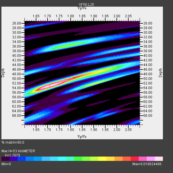
| Thickness Estimate: | 53 km |
| Thickness StdDev: | 8.5 km |
| Vp/Vs Estimate: | 1.71 |
| Vp/Vs StdDev: | 0.09 |
| Vs Estimate: | 3.693 km/s |
| Poisson's Ratio: | 0.24 |
| Peak Value: | 0.02 |
| Assumed Vp: | 6.306 km/s |
| Ps Weight: | 0.33333334 |
| PpPs Weight: | 0.33333334 |
| PsPs Weight: | 0.33333328 |
| Residual Complexity: | 0.781 |
| Nearby stations H: | +- |
| (2.0 deg) Vp/Vs: | +- |
2 with match > 90% ( 25.0 %) and 8 with match > 80% ( 100.0 %) out of 8.
Download stack as xyz text file.
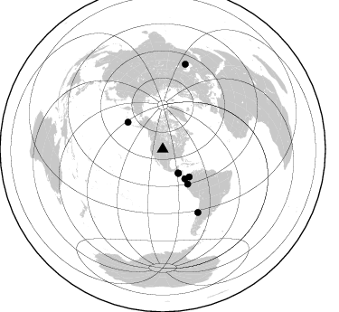
Azimuth Distribution of Events:
Prior Results for this Station
| Study | Thickness | Vp/Vs | Vp | Vs | Poissons Ratio | Extra |
| EARS | 53 km | 1.71 | 6.306 km/s | 3.693 km/s | 0.24 | |
| Crust2.0 | 50 km | 1.76 | 6.306 km/s | 3.584 km/s | 0.26 | P4,orogen/50km, Urals, Tethian Orogen, Rockies 1 km seds. |
| Global Maxima | 53 km | 1.71 | 6.306 km/s | 3.693 km/s | 0.24 | amp=0.018824486 |
| Local Maxima 1 | 49 km | 1.83 | 6.306 km/s | 3.451 km/s | 0.29 | amp=0.014244601 |
| Local Maxima 2 | 52 km | 1.90 | 6.306 km/s | 3.315 km/s | 0.31 | amp=0.011578578 |
| Local Maxima 3 | 35 km | 1.81 | 6.306 km/s | 3.479 km/s | 0.28 | amp=0.01032017 |
| Local Maxima 4 | 46 km | 1.95 | 6.306 km/s | 3.238 km/s | 0.32 | amp=0.008108167 |
| Predicted Arrivals for vertical incidence (zero ray parameter) | |
| Ps | 5.95 SECOND |
| PpPs | 22.76 SECOND |
| PsPs/PpSs | 28.70 SECOND |
Events Processed for this Station
Download zip of receiver functions as SAC
Plot maxima for each earthquake.
Events Used in the Stack
(8 events)| Radial Match | Distance | Baz | FERegion | Time | Lat/Lon | Depth | Magnitude |
| 94.24311 | 42.3 deg | 136.156 deg | Panama-Colombia Border Region | 2000/11/08 06:59:58 GMT | (7.0, -77.8) | 17 km | 6.0 MB, 6.4 MS, 6.5 MW, 6.2 ML |
| 93.708984 | 32.0 deg | 147.056 deg | El Salvador | 2001/01/13 17:33:32 GMT | (13.0, -88.7) | 60 km | 6.4 MB, 7.8 MS, 7.7 MW, 7.5 ME |
| 89.260605 | 47.3 deg | 144.504 deg | Near Coast Of Ecuador | 2000/09/28 23:23:43 GMT | (-0.2, -80.6) | 23 km | 5.8 MB, 6.0 MS, 6.6 MW, 6.4 MW |
| 82.80629 | 97.5 deg | 14.978 deg | Turkmenistan | 2000/12/06 17:11:06 GMT | (39.6, 54.8) | 30 km | 6.7 MB, 7.5 MS, 7.0 MW, 6.9 ME |
| 81.84344 | 79.9 deg | 150.968 deg | Near Coast Of Central Chile | 2001/03/15 13:02:42 GMT | (-32.3, -71.5) | 37 km | 6.1 MB, 5.6 MS, 6.0 MW, 5.4 MD |
| 80.54075 | 31.3 deg | 147.028 deg | El Salvador | 2001/02/13 14:22:05 GMT | (13.7, -88.9) | 10 km | 5.5 MB, 6.5 MS, 6.6 MW, 6.1 MD |
| 80.46965 | 48.7 deg | 307.653 deg | Andreanof Islands, Aleutian Is. | 2001/02/01 18:19:30 GMT | (51.4, -177.8) | 33 km | 5.6 MB, 5.6 MS, 6.0 MW, 5.9 MW |
| 80.08825 | 40.8 deg | 143.245 deg | South Of Panama | 2000/12/12 05:26:45 GMT | (6.0, -82.7) | 10 km | 5.8 MB, 5.7 MS, 6.3 ME, 6.1 MW |
Losers
(0 events)| Radial Match | Distance | Baz | FERegion | Time | Lat/Lon | Depth | Magnitude | Reason |
