
Station XF L22 - XF.L22
Network: XF00 - Laramie Telemetered Brad-band Array
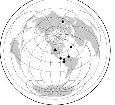
Nearby stations (2 deg radius)
| Station | Name | (Lat, Lon) | Start / End | Elevation |
| L22 | XF.L22 | (41.42, -105.88) | 2000-09-01 / 2002-01-01 | 7320 m |
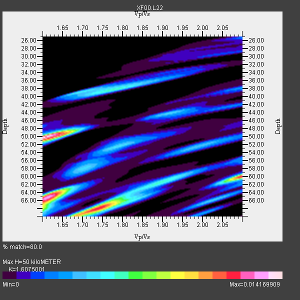
| Crust2 Type: | P4,orogen/50km, Urals, Tethian Orogen, Rockies 1 km seds. |
| Thickness Estimate: | 50 km |
| Thickness StdDev: | 8.7 km |
| Vp/Vs Estimate: | 1.61 |
| Vp/Vs StdDev: | 0.18 |
| Vs Estimate: | 3.923 km/s |
| Poisson's Ratio: | 0.18 |
| Peak Value: | 0.01 |
| Assumed Vp: | 6.306 km/s |
| Ps Weight: | 0.33333334 |
| PpPs Weight: | 0.33333334 |
| PsPs Weight: | 0.33333328 |
| Residual Complexity: | 0.887 |
| Nearby stations H: | +- |
| (2.0 deg) Vp/Vs: | +- |
3 with match > 90% ( 50.0 %) and 6 with match > 80% ( 100.0 %) out of 6.
Download stack as xyz text file.
Azimuth Distribution of Events:
Prior Results for this Station
| Study | Thickness | Vp/Vs | Vp | Vs | Poissons Ratio | Extra |
| EARS | 50 km | 1.61 | 6.306 km/s | 3.923 km/s | 0.18 | |
| Crust2.0 | 50 km | 1.76 | 6.306 km/s | 3.584 km/s | 0.26 | P4,orogen/50km, Urals, Tethian Orogen, Rockies 1 km seds. |
| Global Maxima | 50 km | 1.61 | 6.306 km/s | 3.923 km/s | 0.18 | amp=0.014169909 |
| Local Maxima 1 | 65 km | 1.62 | 6.306 km/s | 3.905 km/s | 0.19 | amp=0.0132124275 |
| Local Maxima 2 | 60 km | 2.10 | 6.306 km/s | 3.006 km/s | 0.35 | amp=0.012119532 |
| Local Maxima 3 | 68 km | 1.74 | 6.306 km/s | 3.629 km/s | 0.25 | amp=0.009297824 |
| Local Maxima 4 | 68 km | 1.60 | 6.306 km/s | 3.941 km/s | 0.18 | amp=0.006299866 |
| Predicted Arrivals for vertical incidence (zero ray parameter) | |
| Ps | 4.82 SECOND |
| PpPs | 20.67 SECOND |
| PsPs/PpSs | 25.49 SECOND |
Events Processed for this Station
Download zip of receiver functions as SAC
Plot maxima for each earthquake.
Events Used in the Stack
(6 events)| Radial Match | Distance | Baz | FERegion | Time | Lat/Lon | Depth | Magnitude |
| 93.02258 | 42.3 deg | 136.143 deg | Panama-Colombia Border Region | 2000/11/08 06:59:58 GMT | (7.0, -77.8) | 17 km | 6.0 MB, 6.4 MS, 6.5 MW, 6.2 ML |
| 92.83162 | 32.0 deg | 147.032 deg | El Salvador | 2001/01/13 17:33:32 GMT | (13.0, -88.7) | 60 km | 6.4 MB, 7.8 MS, 7.7 MW, 7.5 ME |
| 91.401436 | 47.4 deg | 144.482 deg | Near Coast Of Ecuador | 2000/09/28 23:23:43 GMT | (-0.2, -80.6) | 23 km | 5.8 MB, 6.0 MS, 6.6 MW, 6.4 MW |
| 82.72873 | 97.5 deg | 14.95 deg | Turkmenistan | 2000/12/06 17:11:06 GMT | (39.6, 54.8) | 30 km | 6.7 MB, 7.5 MS, 7.0 MW, 6.9 ME |
| 80.66731 | 51.9 deg | 78.602 deg | Northern Mid-Atlantic Ridge | 2000/10/05 13:39:11 GMT | (31.7, -41.0) | 10 km | 5.4 MB, 6.1 MS, 6.0 MW, 5.9 MW |
| 80.23924 | 48.4 deg | 115.864 deg | Windward Islands | 2000/10/04 14:37:44 GMT | (11.1, -62.6) | 110 km | 5.6 MB, 5.4 MS, 6.1 MW, 5.9 MD |
Losers
(0 events)| Radial Match | Distance | Baz | FERegion | Time | Lat/Lon | Depth | Magnitude | Reason |
