
Station XF L24 - XF.L24
Network: XF00 - Laramie Telemetered Brad-band Array
Nearby stations (2 deg radius)
| Station | Name | (Lat, Lon) | Start / End | Elevation |
| L24 | XF.L24 | (41.49, -105.89) | 2000-09-01 / 2002-01-01 | 1.8 m |
| Crust2 Type: | P4,orogen/50km, Urals, Tethian Orogen, Rockies 1 km seds. |
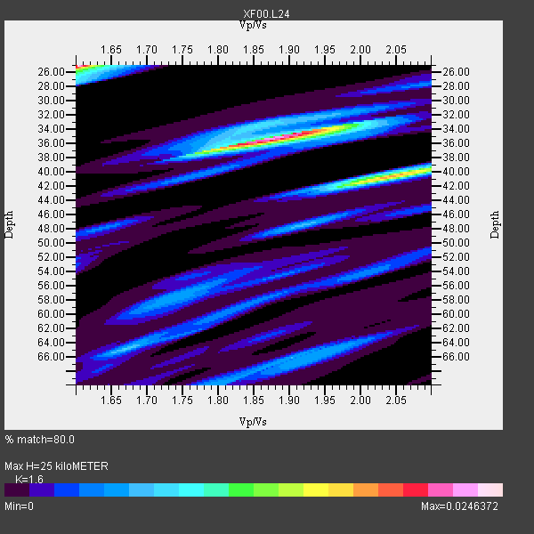
| Thickness Estimate: | 25 km |
| Thickness StdDev: | 13 km |
| Vp/Vs Estimate: | 1.60 |
| Vp/Vs StdDev: | 0.17 |
| Vs Estimate: | 3.941 km/s |
| Poisson's Ratio: | 0.18 |
| Peak Value: | 0.02 |
| Assumed Vp: | 6.306 km/s |
| Ps Weight: | 0.33333334 |
| PpPs Weight: | 0.33333334 |
| PsPs Weight: | 0.33333328 |
| Residual Complexity: | 0.956 |
| Nearby stations H: | +- |
| (2.0 deg) Vp/Vs: | +- |
2 with match > 90% ( 50.0 %) and 4 with match > 80% ( 100.0 %) out of 4.
Download stack as xyz text file.
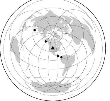
Azimuth Distribution of Events:
Prior Results for this Station
| Study | Thickness | Vp/Vs | Vp | Vs | Poissons Ratio | Extra |
| EARS | 25 km | 1.60 | 6.306 km/s | 3.941 km/s | 0.18 | |
| Crust2.0 | 50 km | 1.76 | 6.306 km/s | 3.584 km/s | 0.26 | P4,orogen/50km, Urals, Tethian Orogen, Rockies 1 km seds. |
| Global Maxima | 25 km | 1.60 | 6.306 km/s | 3.941 km/s | 0.18 | amp=0.0246372 |
| Local Maxima 1 | 35 km | 1.87 | 6.306 km/s | 3.368 km/s | 0.30 | amp=0.02256418 |
| Local Maxima 2 | 40 km | 2.05 | 6.306 km/s | 3.084 km/s | 0.34 | amp=0.017669573 |
| Local Maxima 3 | 64 km | 1.68 | 6.306 km/s | 3.759 km/s | 0.22 | amp=0.006932051 |
| Local Maxima 4 | 70 km | 1.80 | 6.306 km/s | 3.508 km/s | 0.28 | amp=0.006086767 |
| Predicted Arrivals for vertical incidence (zero ray parameter) | |
| Ps | 2.38 SECOND |
| PpPs | 10.31 SECOND |
| PsPs/PpSs | 12.69 SECOND |
Events Processed for this Station
Download zip of receiver functions as SAC
Plot maxima for each earthquake.
Events Used in the Stack
(4 events)| Radial Match | Distance | Baz | FERegion | Time | Lat/Lon | Depth | Magnitude |
| 92.145454 | 32.1 deg | 147.063 deg | El Salvador | 2001/01/13 17:33:32 GMT | (13.0, -88.7) | 60 km | 6.4 MB, 7.8 MS, 7.7 MW, 7.5 ME |
| 90.92048 | 42.4 deg | 136.173 deg | Panama-Colombia Border Region | 2000/11/08 06:59:58 GMT | (7.0, -77.8) | 17 km | 6.0 MB, 6.4 MS, 6.5 MW, 6.2 ML |
| 83.46236 | 33.8 deg | 313.812 deg | Kodiak Island Region, Alaska | 2001/01/10 16:02:44 GMT | (57.1, -153.2) | 33 km | 6.2 MB, 6.8 MS, 7.1 MW, 6.8 ML |
| 82.245995 | 87.6 deg | 314.954 deg | Western Honshu, Japan | 2001/03/24 06:27:53 GMT | (34.1, 132.5) | 50 km | 6.4 MB, 6.5 MS, 6.8 MW, 6.4 ME |
Losers
(0 events)| Radial Match | Distance | Baz | FERegion | Time | Lat/Lon | Depth | Magnitude | Reason |
