
Station XF L26 - XF.L26
Network: XF00 - Laramie Telemetered Brad-band Array
Nearby stations (2 deg radius)
| Station | Name | (Lat, Lon) | Start / End | Elevation |
| L26 | XF.L26 | (41.50, -105.95) | 2000-09-01 / 2002-01-01 | 1.8 m |
| Crust2 Type: | P4,orogen/50km, Urals, Tethian Orogen, Rockies 1 km seds. |
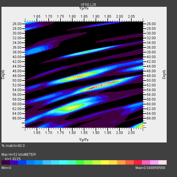
| Thickness Estimate: | 52 km |
| Thickness StdDev: | 4.9 km |
| Vp/Vs Estimate: | 1.92 |
| Vp/Vs StdDev: | 0.07 |
| Vs Estimate: | 3.28 km/s |
| Poisson's Ratio: | 0.31 |
| Peak Value: | 0.05 |
| Assumed Vp: | 6.306 km/s |
| Ps Weight: | 0.33333334 |
| PpPs Weight: | 0.33333334 |
| PsPs Weight: | 0.33333328 |
| Residual Complexity: | 0.734 |
| Nearby stations H: | +- |
| (2.0 deg) Vp/Vs: | +- |
2 with match > 90% ( 40.0 %) and 5 with match > 80% ( 100.0 %) out of 5.
Download stack as xyz text file.
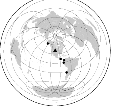
Azimuth Distribution of Events:
Prior Results for this Station
| Study | Thickness | Vp/Vs | Vp | Vs | Poissons Ratio | Extra |
| EARS | 52 km | 1.92 | 6.306 km/s | 3.28 km/s | 0.31 | |
| Crust2.0 | 50 km | 1.76 | 6.306 km/s | 3.584 km/s | 0.26 | P4,orogen/50km, Urals, Tethian Orogen, Rockies 1 km seds. |
| Global Maxima | 52 km | 1.92 | 6.306 km/s | 3.28 km/s | 0.31 | amp=0.048858568 |
| Local Maxima 1 | 48 km | 1.81 | 6.306 km/s | 3.494 km/s | 0.28 | amp=0.03803266 |
| Local Maxima 2 | 69 km | 2.10 | 6.306 km/s | 3.006 km/s | 0.35 | amp=0.036014218 |
| Local Maxima 3 | 38 km | 1.86 | 6.306 km/s | 3.395 km/s | 0.30 | amp=0.023799732 |
| Local Maxima 4 | 61 km | 1.82 | 6.306 km/s | 3.47 km/s | 0.28 | amp=0.023727046 |
| Predicted Arrivals for vertical incidence (zero ray parameter) | |
| Ps | 7.61 SECOND |
| PpPs | 24.10 SECOND |
| PsPs/PpSs | 31.71 SECOND |
Events Processed for this Station
Download zip of receiver functions as SAC
Plot maxima for each earthquake.
Events Used in the Stack
(5 events)| Radial Match | Distance | Baz | FERegion | Time | Lat/Lon | Depth | Magnitude |
| 92.850426 | 42.4 deg | 136.118 deg | Panama-Colombia Border Region | 2000/11/08 06:59:58 GMT | (7.0, -77.8) | 17 km | 6.0 MB, 6.4 MS, 6.5 MW, 6.2 ML |
| 91.1877 | 32.1 deg | 146.989 deg | El Salvador | 2001/01/13 17:33:32 GMT | (13.0, -88.7) | 60 km | 6.4 MB, 7.8 MS, 7.7 MW, 7.5 ME |
| 87.32416 | 33.8 deg | 313.802 deg | Kodiak Island Region, Alaska | 2001/01/10 16:02:44 GMT | (57.1, -153.2) | 33 km | 6.2 MB, 6.8 MS, 7.1 MW, 6.8 ML |
| 86.821205 | 79.8 deg | 152.305 deg | Off Coast Of Central Chile | 2001/04/09 09:00:57 GMT | (-32.7, -73.1) | 11 km | 6.1 MB, 6.3 MS, 6.7 MW, 6.3 ME |
| 82.67433 | 47.4 deg | 144.443 deg | Near Coast Of Ecuador | 2000/09/28 23:23:43 GMT | (-0.2, -80.6) | 23 km | 5.8 MB, 6.0 MS, 6.6 MW, 6.4 MW |
Losers
(0 events)| Radial Match | Distance | Baz | FERegion | Time | Lat/Lon | Depth | Magnitude | Reason |
