
Station XF L27 - XF.L27
Network: XF00 - Laramie Telemetered Brad-band Array
Nearby stations (2 deg radius)
| Station | Name | (Lat, Lon) | Start / End | Elevation |
| L27 | XF.L27 | (41.52, -105.96) | 2000-09-01 / 2002-01-01 | 1.8 m |
| Crust2 Type: | P4,orogen/50km, Urals, Tethian Orogen, Rockies 1 km seds. |
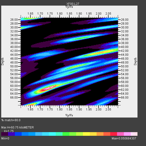
| Thickness Estimate: | 61 km |
| Thickness StdDev: | 13 km |
| Vp/Vs Estimate: | 1.75 |
| Vp/Vs StdDev: | 0.14 |
| Vs Estimate: | 3.603 km/s |
| Poisson's Ratio: | 0.26 |
| Peak Value: | 0.05 |
| Assumed Vp: | 6.306 km/s |
| Ps Weight: | 0.33333334 |
| PpPs Weight: | 0.33333334 |
| PsPs Weight: | 0.33333328 |
| Residual Complexity: | 0.768 |
| Nearby stations H: | +- |
| (2.0 deg) Vp/Vs: | +- |
0 with match > 90% ( 0.0 %) and 4 with match > 80% ( 100.0 %) out of 4.
Download stack as xyz text file.
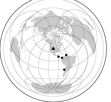
Azimuth Distribution of Events:
Prior Results for this Station
| Study | Thickness | Vp/Vs | Vp | Vs | Poissons Ratio | Extra |
| EARS | 61 km | 1.75 | 6.306 km/s | 3.603 km/s | 0.26 | |
| Crust2.0 | 50 km | 1.76 | 6.306 km/s | 3.584 km/s | 0.26 | P4,orogen/50km, Urals, Tethian Orogen, Rockies 1 km seds. |
| Global Maxima | 61 km | 1.75 | 6.306 km/s | 3.603 km/s | 0.26 | amp=0.050684307 |
| Local Maxima 1 | 43 km | 2.01 | 6.306 km/s | 3.137 km/s | 0.34 | amp=0.03589754 |
| Local Maxima 2 | 30 km | 1.60 | 6.306 km/s | 3.941 km/s | 0.18 | amp=0.03181792 |
| Local Maxima 3 | 70 km | 1.65 | 6.306 km/s | 3.81 km/s | 0.21 | amp=0.031615164 |
| Local Maxima 4 | 25 km | 1.66 | 6.306 km/s | 3.793 km/s | 0.22 | amp=0.030948695 |
| Predicted Arrivals for vertical incidence (zero ray parameter) | |
| Ps | 7.23 SECOND |
| PpPs | 26.49 SECOND |
| PsPs/PpSs | 33.72 SECOND |
Events Processed for this Station
Download zip of receiver functions as SAC
Plot maxima for each earthquake.
Events Used in the Stack
(4 events)| Radial Match | Distance | Baz | FERegion | Time | Lat/Lon | Depth | Magnitude |
| 86.71797 | 79.8 deg | 152.294 deg | Off Coast Of Central Chile | 2001/04/09 09:00:57 GMT | (-32.7, -73.1) | 11 km | 6.1 MB, 6.3 MS, 6.7 MW, 6.3 ME |
| 86.57499 | 32.1 deg | 146.98 deg | El Salvador | 2001/01/13 17:33:32 GMT | (13.0, -88.7) | 60 km | 6.4 MB, 7.8 MS, 7.7 MW, 7.5 ME |
| 84.12781 | 42.5 deg | 136.114 deg | Panama-Colombia Border Region | 2000/11/08 06:59:58 GMT | (7.0, -77.8) | 17 km | 6.0 MB, 6.4 MS, 6.5 MW, 6.2 ML |
| 82.87056 | 48.5 deg | 115.865 deg | Windward Islands | 2000/10/04 14:37:44 GMT | (11.1, -62.6) | 110 km | 5.6 MB, 5.4 MS, 6.1 MW, 5.9 MD |
Losers
(0 events)| Radial Match | Distance | Baz | FERegion | Time | Lat/Lon | Depth | Magnitude | Reason |
