
Station XF ALPN - Alpine, Alpine, Calif.
Network: XF94 - Penninsular Ranges, California
Nearby stations (2 deg radius)
| Station | Name | (Lat, Lon) | Start / End | Elevation |
| ALPN | Alpine, Alpine, Calif. | (32.87, -116.75) | 1994-03-24 / 1994-11-04 | 2693 m |
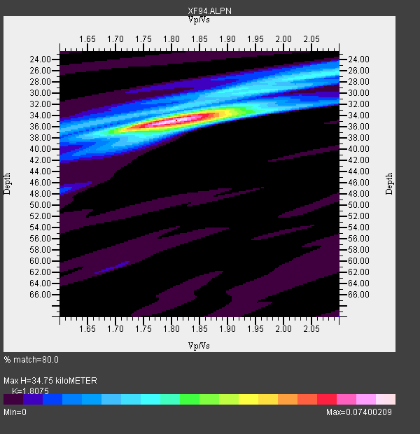
| Crust2 Type: | MG,very thin extended crust, 0.5 km seds. |
| Thickness Estimate: | 35 km |
| Thickness StdDev: | 0.7 km |
| Vp/Vs Estimate: | 1.81 |
| Vp/Vs StdDev: | 0.03 |
| Vs Estimate: | 3.465 km/s |
| Poisson's Ratio: | 0.28 |
| Peak Value: | 0.07 |
| Assumed Vp: | 6.264 km/s |
| Ps Weight: | 0.33333334 |
| PpPs Weight: | 0.33333334 |
| PsPs Weight: | 0.33333328 |
| Residual Complexity: | 0.386 |
| Nearby stations H: | +- |
| (2.0 deg) Vp/Vs: | +- |
4 with match > 90% ( 22.222221 %) and 5 with match > 80% ( 27.777779 %) out of 18.
Download stack as xyz text file.
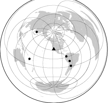
Azimuth Distribution of Events:
Prior Results for this Station
| Study | Thickness | Vp/Vs | Vp | Vs | Poissons Ratio | Extra |
| EARS | 35 km | 1.81 | 6.264 km/s | 3.465 km/s | 0.28 | |
| Crust2.0 | 28 km | 1.78 | 6.264 km/s | 3.524 km/s | 0.27 | MG,very thin extended crust, 0.5 km seds. |
| Zhu S. Cal. | 35 km | 1.84 | 6.3 km/s | 3.424 km/s | 0.29 | |
| Global Maxima | 35 km | 1.81 | 6.264 km/s | 3.465 km/s | 0.28 | amp=0.07400209 |
| Local Maxima 1 | 26 km | 2.07 | 6.264 km/s | 3.03 km/s | 0.35 | amp=0.025627408 |
| Local Maxima 2 | 35 km | 1.84 | 6.264 km/s | 3.4 km/s | 0.29 | amp=0.021428514 |
| Local Maxima 3 | 34 km | 1.70 | 6.264 km/s | 3.679 km/s | 0.24 | amp=0.018879937 |
| Local Maxima 4 | 30 km | 1.88 | 6.264 km/s | 3.341 km/s | 0.30 | amp=0.009945551 |
| Predicted Arrivals for vertical incidence (zero ray parameter) | |
| Ps | 4.48 SECOND |
| PpPs | 15.58 SECOND |
| PsPs/PpSs | 20.06 SECOND |
Events Processed for this Station
Download zip of receiver functions as SAC
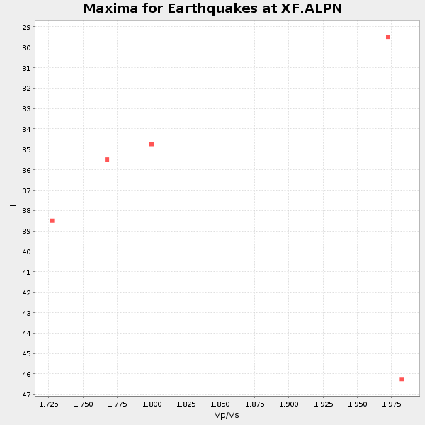
Plot maxima for each earthquake.
Events Used in the Stack
(5 events)| Radial Match | Distance | Baz | FERegion | Time | Lat/Lon | Depth | Magnitude |
| 96.6979 | 66.0 deg | 126.445 deg | Northern Bolivia | 1994/06/09 00:33:16 GMT | (-13.8, -67.6) | 637 km | 6.9 MB, 6.8 MS, 8.3 UNKNOWN, 8.2 MW |
| 94.42207 | 87.4 deg | 248.456 deg | Vanuatu Islands | 1994/07/13 02:35:55 GMT | (-16.6, 167.5) | 33 km | 6.3 MB, 7.4 MS, 7.3 UNKNOWN, 7.1 MW |
| 93.04276 | 48.3 deg | 119.42 deg | Colombia | 1994/06/06 20:47:39 GMT | (2.9, -76.1) | 9.0 km | 6.4 MB, 6.4 MS, 6.3 UNKNOWN, 6.8 MW |
| 92.4834 | 81.7 deg | 315.336 deg | Primor'ye, Russia | 1994/07/21 18:36:31 GMT | (42.3, 132.9) | 473 km | 6.4 MB, 7.2 UNKNOWN |
| 87.67431 | 79.5 deg | 133.835 deg | Santiago Del Estero Prov., Arg. | 1994/05/10 06:36:28 GMT | (-28.5, -63.1) | 605 km | 6.4 MB, 6.2 UNKNOWN, 6.9 MW |
Losers
(13 events)| Radial Match | Distance | Baz | FERegion | Time | Lat/Lon | Depth | Magnitude | Reason |
| 76.49571 | 48.5 deg | 111.354 deg | Northern Colombia | 1994/05/31 17:41:55 GMT | (7.4, -72.1) | 13 km | 6.3 MB, 5.6 MS, 6.0 UNKNOWN, 6.0 MW | |
| 75.86724 | 41.6 deg | 313.736 deg | Fox Islands, Aleutian Islands | 1994/07/29 00:17:48 GMT | (52.4, -168.3) | 33 km | 5.9 MB, 5.6 MS, 5.8 UNKNOWN, 5.6 ML | |
| 72.47605 | 87.1 deg | 247.673 deg | Vanuatu Islands | 1994/05/04 06:37:37 GMT | (-17.1, 168.3) | 221 km | 5.7 MB | |
| 72.152435 | 86.7 deg | 248.698 deg | Vanuatu Islands | 1994/04/26 23:36:45 GMT | (-16.0, 168.0) | 187 km | 5.6 MB | |
| 69.2601 | 65.2 deg | 129.608 deg | Southern Peru | 1994/06/16 18:41:31 GMT | (-15.2, -70.3) | 225 km | 5.6 MB, 5.8 UNKNOWN, 6.1 MW | |
| 67.661736 | 61.9 deg | 316.212 deg | Near East Coast Of Kamchatka | 1994/08/02 14:17:54 GMT | (52.4, 158.1) | 170 km | 5.8 MB, 5.9 UNKNOWN, 5.8 MW | |
| 66.9535 | 76.7 deg | 233.362 deg | Tonga Islands | 1994/04/27 09:23:27 GMT | (-21.5, -173.7) | 35 km | 6.2 MB, 6.1 MS, 6.0 UNKNOWN, 6.4 MW | |
| 63.285046 | 72.3 deg | 237.284 deg | Tonga Islands | 1994/07/23 12:58:00 GMT | (-15.7, -173.1) | 33 km | 5.6 MS, 5.3 MB | |
| 61.821445 | 75.9 deg | 239.751 deg | Fiji Islands Region | 1994/07/05 02:59:42 GMT | (-16.3, -177.5) | 413 km | 5.4 MB, 5.8 UNKNOWN | |
| 60.908203 | 81.0 deg | 236.738 deg | Fiji Islands Region | 1994/03/31 22:40:53 GMT | (-22.0, -179.6) | 591 km | 5.9 MB, 6.5 UNKNOWN, 6.5 MW | |
| 58.808903 | 69.8 deg | 310.585 deg | East Of Kuril Islands | 1994/08/14 00:46:22 GMT | (44.7, 150.1) | 33 km | 5.9 MB, 5.8 MS, 5.4 UNKNOWN, 6.1 MW | |
| 54.517902 | 79.3 deg | 133.771 deg | Santiago Del Estero Prov., Arg. | 1994/04/29 07:11:30 GMT | (-28.3, -63.2) | 573 km | 6.4 MB, 6.0 UNKNOWN, 6.9 MW | |
| 44.737015 | 68.9 deg | 132.485 deg | Northern Chile | 1994/05/10 01:49:03 GMT | (-19.7, -69.8) | 53 km | 5.8 MB, 4.9 UNKNOWN, 5.9 MW |
