
Station XF BLSY - Blue Sky Ranch, Lakeside, Calif.
Network: XF94 - Penninsular Ranges, California
Nearby stations (2 deg radius)
| Station | Name | (Lat, Lon) | Start / End | Elevation |
| BLSY | Blue Sky Ranch, Lakeside, Calif. | (32.91, -116.88) | 1994-04-14 / 1994-11-04 | 1739 m |
| Crust2 Type: | MG,very thin extended crust, 0.5 km seds. |
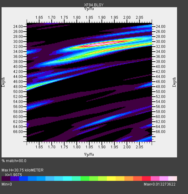
| Thickness Estimate: | 31 km |
| Thickness StdDev: | 6.4 km |
| Vp/Vs Estimate: | 1.91 |
| Vp/Vs StdDev: | 0.12 |
| Vs Estimate: | 3.284 km/s |
| Poisson's Ratio: | 0.31 |
| Peak Value: | 0.01 |
| Assumed Vp: | 6.264 km/s |
| Ps Weight: | 0.33333334 |
| PpPs Weight: | 0.33333334 |
| PsPs Weight: | 0.33333328 |
| Residual Complexity: | 0.571 |
| Nearby stations H: | +- |
| (2.0 deg) Vp/Vs: | +- |
3 with match > 90% ( 15.0 %) and 6 with match > 80% ( 30.0 %) out of 20.
Download stack as xyz text file.
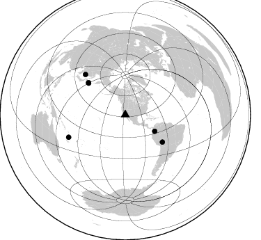
Azimuth Distribution of Events:
Prior Results for this Station
| Study | Thickness | Vp/Vs | Vp | Vs | Poissons Ratio | Extra |
| EARS | 31 km | 1.91 | 6.264 km/s | 3.284 km/s | 0.31 | |
| Crust2.0 | 28 km | 1.78 | 6.264 km/s | 3.524 km/s | 0.27 | MG,very thin extended crust, 0.5 km seds. |
| Zhu S. Cal. | 36 km | 1.82 | 6.3 km/s | 3.462 km/s | 0.28 | |
| Global Maxima | 31 km | 1.91 | 6.264 km/s | 3.284 km/s | 0.31 | amp=0.013273622 |
| Local Maxima 1 | 32 km | 1.98 | 6.264 km/s | 3.159 km/s | 0.33 | amp=0.009856402 |
| Local Maxima 2 | 48 km | 1.63 | 6.264 km/s | 3.837 km/s | 0.20 | amp=0.006991711 |
| Local Maxima 3 | 36 km | 1.80 | 6.264 km/s | 3.48 km/s | 0.28 | amp=0.004379747 |
| Local Maxima 4 | 24 km | 2.10 | 6.264 km/s | 2.986 km/s | 0.35 | amp=0.0033333674 |
| Predicted Arrivals for vertical incidence (zero ray parameter) | |
| Ps | 4.46 SECOND |
| PpPs | 14.27 SECOND |
| PsPs/PpSs | 18.73 SECOND |
Events Processed for this Station
Download zip of receiver functions as SAC
Plot maxima for each earthquake.
Events Used in the Stack
(6 events)| Radial Match | Distance | Baz | FERegion | Time | Lat/Lon | Depth | Magnitude |
| 92.67488 | 87.3 deg | 248.382 deg | Vanuatu Islands | 1994/07/13 02:35:55 GMT | (-16.6, 167.5) | 33 km | 6.3 MB, 7.4 MS, 7.3 UNKNOWN, 7.1 MW |
| 92.15979 | 48.5 deg | 119.334 deg | Colombia | 1994/06/06 20:47:39 GMT | (2.9, -76.1) | 9.0 km | 6.4 MB, 6.4 MS, 6.3 UNKNOWN, 6.8 MW |
| 91.703705 | 66.2 deg | 126.361 deg | Northern Bolivia | 1994/06/09 00:33:16 GMT | (-13.8, -67.6) | 637 km | 6.9 MB, 6.8 MS, 8.3 UNKNOWN, 8.2 MW |
| 89.784996 | 81.6 deg | 315.273 deg | Primor'ye, Russia | 1994/07/21 18:36:31 GMT | (42.3, 132.9) | 473 km | 6.4 MB, 7.2 UNKNOWN |
| 82.6526 | 69.6 deg | 310.531 deg | East Of Kuril Islands | 1994/08/18 04:42:59 GMT | (44.7, 150.2) | 33 km | 6.1 MB, 6.5 MS, 6.6 UNKNOWN, 6.5 MW |
| 80.391754 | 70.3 deg | 310.885 deg | Kuril Islands | 1994/08/20 04:38:51 GMT | (44.7, 149.1) | 33 km | 6.1 MB, 6.0 MS, 5.7 UNKNOWN, 6.3 MW |
Losers
(14 events)| Radial Match | Distance | Baz | FERegion | Time | Lat/Lon | Depth | Magnitude | Reason |
| 97.14691 | 88.6 deg | 186.421 deg | Pacific-Antarctic Ridge | 1994/08/05 19:41:56 GMT | (-55.5, -128.2) | 10 km | 5.5 MS, 5.1 MB | |
| 78.56813 | 46.0 deg | 121.147 deg | South Of Panama | 1994/06/03 11:25:09 GMT | (3.6, -78.8) | 28 km | 5.9 MB, 5.1 MS, 5.1 UNKNOWN, 5.8 MW | |
| 76.921196 | 78.1 deg | 132.671 deg | Santiago Del Estero Prov., Arg. | 1994/08/19 10:02:51 GMT | (-26.7, -63.4) | 565 km | 6.4 MB, 6.5 UNKNOWN, 6.5 MW | |
| 71.773605 | 48.6 deg | 111.282 deg | Northern Colombia | 1994/05/31 17:41:55 GMT | (7.4, -72.1) | 13 km | 6.3 MB, 5.6 MS, 6.0 UNKNOWN, 6.0 MW | |
| 63.715675 | 75.8 deg | 239.658 deg | Fiji Islands Region | 1994/07/05 02:59:42 GMT | (-16.3, -177.5) | 413 km | 5.4 MB, 5.8 UNKNOWN | |
| 60.36341 | 87.3 deg | 248.484 deg | Vanuatu Islands | 1994/07/14 00:09:26 GMT | (-16.5, 167.4) | 33 km | 5.4 MB, 6.0 MS, 5.9 UNKNOWN, 6.1 MW | |
| 59.967587 | 78.1 deg | 307.306 deg | Off East Coast Of Honshu, Japan | 1994/08/16 10:09:34 GMT | (37.8, 142.5) | 34 km | 5.8 MB, 5.2 MS, 5.1 UNKNOWN, 5.8 MW | |
| 58.673183 | 61.8 deg | 316.169 deg | Near East Coast Of Kamchatka | 1994/08/02 14:17:54 GMT | (52.4, 158.1) | 170 km | 5.8 MB, 5.9 UNKNOWN, 5.8 MW | |
| 58.64355 | 87.3 deg | 248.118 deg | Vanuatu Islands | 1994/07/29 07:53:31 GMT | (-16.8, 167.7) | 33 km | 5.5 MB, 5.8 MS, 6.2 UNKNOWN, 5.9 MW | |
| 53.2508 | 69.6 deg | 310.564 deg | East Of Kuril Islands | 1994/08/28 18:37:19 GMT | (44.7, 150.2) | 14 km | 6.0 MB, 6.5 MS, 6.3 UNKNOWN, 6.7 MW | |
| 50.15905 | 78.9 deg | 235.063 deg | Fiji Islands Region | 1994/08/11 19:32:52 GMT | (-21.7, -176.8) | 180 km | 5.5 MB | |
| 49.397717 | 65.3 deg | 129.52 deg | Southern Peru | 1994/06/16 18:41:31 GMT | (-15.2, -70.3) | 225 km | 5.6 MB, 5.8 UNKNOWN, 6.1 MW | |
| 48.490967 | 69.7 deg | 310.53 deg | East Of Kuril Islands | 1994/08/14 00:46:22 GMT | (44.7, 150.1) | 33 km | 5.9 MB, 5.8 MS, 5.4 UNKNOWN, 6.1 MW | |
| 47.58983 | 76.7 deg | 233.326 deg | Tonga Islands | 1994/08/11 20:42:09 GMT | (-21.5, -173.8) | 33 km | 5.8 MB, 5.5 MS, 5.8 UNKNOWN |
