
Station XF DN1N - Down Stream 1 North
Network: XF95 - Antarctic Microearthquake Project
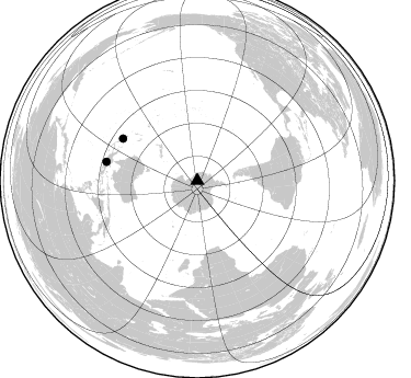
Nearby stations (2 deg radius)
| Station | Name | (Lat, Lon) | Start / End | Elevation |
| DN1N | Down Stream 1 North | (-82.38, -142.16) | 1995-12-11 / 2499-01-01 | 262 m |
| Crust2 Type: | N3,highly extended crust, 1 km ice |
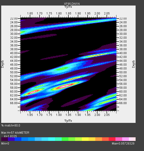
| Thickness Estimate: | 57 km |
| Thickness StdDev: | 3.4 km |
| Vp/Vs Estimate: | 1.83 |
| Vp/Vs StdDev: | 0.08 |
| Vs Estimate: | 3.292 km/s |
| Poisson's Ratio: | 0.29 |
| Peak Value: | 0.06 |
| Assumed Vp: | 6.032 km/s |
| Ps Weight: | 0.33333334 |
| PpPs Weight: | 0.33333334 |
| PsPs Weight: | 0.33333328 |
| Residual Complexity: | 0.817 |
| Nearby stations H: | +- |
| (2.0 deg) Vp/Vs: | +- |
0 with match > 90% ( 0.0 %) and 2 with match > 80% ( 16.666666 %) out of 12.
Download stack as xyz text file.
Azimuth Distribution of Events:
Prior Results for this Station
| Study | Thickness | Vp/Vs | Vp | Vs | Poissons Ratio | Extra |
| EARS | 57 km | 1.83 | 6.032 km/s | 3.292 km/s | 0.29 | |
| Crust2.0 | 26 km | 1.78 | 6.032 km/s | 3.396 km/s | 0.27 | N3,highly extended crust, 1 km ice |
| Global Maxima | 57 km | 1.83 | 6.032 km/s | 3.292 km/s | 0.29 | amp=0.05729329 |
| Local Maxima 1 | 60 km | 1.67 | 6.032 km/s | 3.618 km/s | 0.22 | amp=0.04439566 |
| Local Maxima 2 | 41 km | 2.00 | 6.032 km/s | 3.024 km/s | 0.33 | amp=0.04252396 |
| Local Maxima 3 | 54 km | 1.86 | 6.032 km/s | 3.239 km/s | 0.30 | amp=0.037675183 |
| Local Maxima 4 | 65 km | 2.05 | 6.032 km/s | 2.943 km/s | 0.34 | amp=0.03426845 |
| Predicted Arrivals for vertical incidence (zero ray parameter) | |
| Ps | 7.87 SECOND |
| PpPs | 26.76 SECOND |
| PsPs/PpSs | 34.63 SECOND |
Events Processed for this Station
Download zip of receiver functions as SAC
Plot maxima for each earthquake.
Events Used in the Stack
(2 events)| Radial Match | Distance | Baz | FERegion | Time | Lat/Lon | Depth | Magnitude |
| 83.79116 | 77.8 deg | 299.595 deg | Solomon Islands | 1996/01/11 03:51:34 GMT | (-8.4, 158.6) | 96 km | 5.5 MB, 5.6 UNKNOWN, 5.9 MW |
| 82.693825 | 84.7 deg | 281.838 deg | Irian Jaya, Indonesia | 1995/12/19 23:28:12 GMT | (-3.7, 140.3) | 71 km | 6.2 MB, 6.5 UNKNOWN |
Losers
(10 events)| Radial Match | Distance | Baz | FERegion | Time | Lat/Lon | Depth | Magnitude | Reason |
| 90.448105 | 83.0 deg | 270.4 deg | Banda Sea | 1995/12/25 04:43:24 GMT | (-6.9, 129.2) | 150 km | 6.2 MB, 7.1 UNKNOWN, 7.1 MW | |
| 87.2781 | 61.9 deg | 310.174 deg | Southeast Of Loyalty Islands | 1996/01/12 02:17:34 GMT | (-23.2, 170.8) | 33 km | 5.8 MB, 5.5 MS, 5.5 UNKNOWN, 6.0 MW | |
| 82.53558 | 84.0 deg | 281.52 deg | Irian Jaya, Indonesia | 1996/01/17 10:06:45 GMT | (-4.4, 140.0) | 104 km | 5.6 MB, 6.1 UNKNOWN, 6.1 MW | |
| 80.973236 | 55.8 deg | 322.512 deg | Kermadec Islands Region | 1995/12/25 03:06:34 GMT | (-28.2, -176.9) | 33 km | 5.4 MB, 6.0 MS | |
| 80.260254 | 83.2 deg | 274.879 deg | Aru Islands Region, Indonesia | 1996/01/10 22:36:03 GMT | (-6.1, 133.6) | 37 km | 5.8 MB, 5.6 MS, 6.0 UNKNOWN, 5.9 MW | |
| 75.1688 | 62.3 deg | 325.443 deg | Tonga Islands | 1995/12/26 16:55:19 GMT | (-21.4, -174.8) | 33 km | 5.4 MB, 5.9 MS, 5.9 UNKNOWN, 5.7 MW | |
| 75.15782 | 81.8 deg | 292.78 deg | New Britain Region, P.N.G. | 1995/12/26 21:55:20 GMT | (-5.2, 151.4) | 33 km | 5.8 UNKNOWN, 5.4 MS, 5.4 MB | |
| 73.40461 | 91.8 deg | 262.303 deg | Minahassa Peninsula, Sulawesi | 1996/01/01 08:05:11 GMT | (0.7, 120.0) | 33 km | 6.2 MB, 7.7 MS, 7.8 UNKNOWN, 7.8 MW | |
| 73.372665 | 63.4 deg | 325.983 deg | Tonga Islands | 1996/01/01 01:34:15 GMT | (-20.3, -174.4) | 33 km | 5.8 MS, 5.3 MB | |
| 65.57622 | 65.2 deg | 322.902 deg | Fiji Islands Region | 1996/01/16 05:15:27 GMT | (-18.7, -177.5) | 334 km | 5.7 UNKNOWN, 5.4 MB |
