
Station XF STC2 - Ice Stream Charlie 2
Network: XF95 - Antarctic Microearthquake Project
Nearby stations (2 deg radius)
| Station | Name | (Lat, Lon) | Start / End | Elevation |
| STC2 | Ice Stream Charlie 2 | (-82.35, -136.08) | 1995-12-06 / 2499-01-01 | 508 m |
| Crust2 Type: | N3,highly extended crust, 1 km ice |
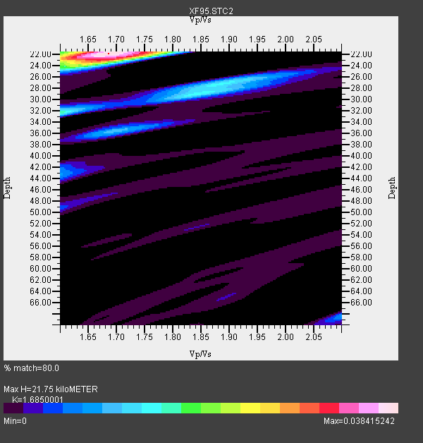
| Thickness Estimate: | 22 km |
| Thickness StdDev: | 4.0 km |
| Vp/Vs Estimate: | 1.69 |
| Vp/Vs StdDev: | 0.08 |
| Vs Estimate: | 3.58 km/s |
| Poisson's Ratio: | 0.23 |
| Peak Value: | 0.04 |
| Assumed Vp: | 6.032 km/s |
| Ps Weight: | 0.33333334 |
| PpPs Weight: | 0.33333334 |
| PsPs Weight: | 0.33333328 |
| Residual Complexity: | 0.529 |
| Nearby stations H: | +- |
| (2.0 deg) Vp/Vs: | +- |
2 with match > 90% ( 20.0 %) and 7 with match > 80% ( 70.0 %) out of 10.
Download stack as xyz text file.
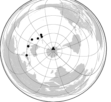
Azimuth Distribution of Events:
Prior Results for this Station
| Study | Thickness | Vp/Vs | Vp | Vs | Poissons Ratio | Extra |
| EARS | 22 km | 1.69 | 6.032 km/s | 3.58 km/s | 0.23 | |
| Crust2.0 | 26 km | 1.78 | 6.032 km/s | 3.396 km/s | 0.27 | N3,highly extended crust, 1 km ice |
| Global Maxima | 22 km | 1.69 | 6.032 km/s | 3.58 km/s | 0.23 | amp=0.038415242 |
| Local Maxima 1 | 32 km | 1.60 | 6.032 km/s | 3.77 km/s | 0.18 | amp=0.016833667 |
| Local Maxima 2 | 23 km | 1.68 | 6.032 km/s | 3.591 km/s | 0.23 | amp=0.016722593 |
| Local Maxima 3 | 27 km | 1.88 | 6.032 km/s | 3.213 km/s | 0.30 | amp=0.013339441 |
| Local Maxima 4 | 36 km | 1.70 | 6.032 km/s | 3.559 km/s | 0.23 | amp=0.0098564355 |
| Predicted Arrivals for vertical incidence (zero ray parameter) | |
| Ps | 2.47 SECOND |
| PpPs | 9.68 SECOND |
| PsPs/PpSs | 12.15 SECOND |
Events Processed for this Station
Download zip of receiver functions as SAC
Plot maxima for each earthquake.
Events Used in the Stack
(7 events)| Radial Match | Distance | Baz | FERegion | Time | Lat/Lon | Depth | Magnitude |
| 97.258965 | 92.6 deg | 256.276 deg | Minahassa Peninsula, Sulawesi | 1996/01/01 08:05:11 GMT | (0.7, 120.0) | 33 km | 6.2 MB, 7.7 MS, 7.8 UNKNOWN, 7.8 MW |
| 96.809906 | 85.5 deg | 275.801 deg | Irian Jaya, Indonesia | 1995/12/19 23:28:12 GMT | (-3.7, 140.3) | 71 km | 6.2 MB, 6.5 UNKNOWN |
| 88.73859 | 56.3 deg | 316.058 deg | Kermadec Islands Region | 1995/12/25 03:06:34 GMT | (-28.2, -176.9) | 33 km | 5.4 MB, 6.0 MS |
| 87.706535 | 84.8 deg | 275.482 deg | Irian Jaya, Indonesia | 1996/01/17 10:06:45 GMT | (-4.4, 140.0) | 104 km | 5.6 MB, 6.1 UNKNOWN, 6.1 MW |
| 85.447235 | 62.5 deg | 303.877 deg | Southeast Of Loyalty Islands | 1996/01/12 02:17:34 GMT | (-23.2, 170.8) | 33 km | 5.8 MB, 5.5 MS, 5.5 UNKNOWN, 6.0 MW |
| 85.34883 | 62.8 deg | 319.075 deg | Tonga Islands | 1995/12/26 16:55:19 GMT | (-21.4, -174.8) | 33 km | 5.4 MB, 5.9 MS, 5.9 UNKNOWN, 5.7 MW |
| 84.80874 | 78.5 deg | 293.489 deg | Solomon Islands | 1996/01/11 03:51:34 GMT | (-8.4, 158.6) | 96 km | 5.5 MB, 5.6 UNKNOWN, 5.9 MW |
Losers
(3 events)| Radial Match | Distance | Baz | FERegion | Time | Lat/Lon | Depth | Magnitude | Reason |
| 75.92937 | 82.6 deg | 286.715 deg | New Britain Region, P.N.G. | 1995/12/26 21:55:20 GMT | (-5.2, 151.4) | 33 km | 5.8 UNKNOWN, 5.4 MS, 5.4 MB | |
| 72.42863 | 84.0 deg | 268.849 deg | Aru Islands Region, Indonesia | 1996/01/10 22:36:03 GMT | (-6.1, 133.6) | 37 km | 5.8 MB, 5.6 MS, 6.0 UNKNOWN, 5.9 MW | |
| 69.965744 | 63.8 deg | 319.628 deg | Tonga Islands | 1996/01/01 01:34:15 GMT | (-20.3, -174.4) | 33 km | 5.8 MS, 5.3 MB |
