
Station XF STC6 - Ice Stream Charlie 6
Network: XF95 - Antarctic Microearthquake Project
Nearby stations (2 deg radius)
| Station | Name | (Lat, Lon) | Start / End | Elevation |
| STC6 | Ice Stream Charlie 6 | (-82.45, -136.09) | 1995-11-30 / 2499-01-01 | 524 m |
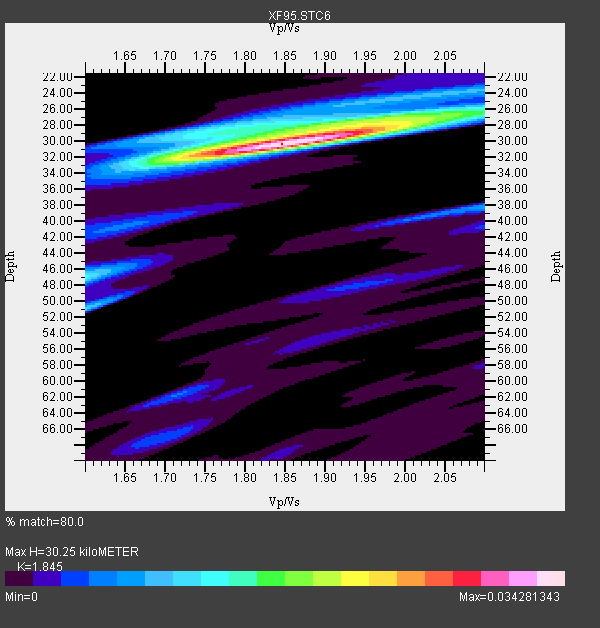
| Crust2 Type: | N3,highly extended crust, 1 km ice |
| Thickness Estimate: | 30 km |
| Thickness StdDev: | 1.5 km |
| Vp/Vs Estimate: | 1.85 |
| Vp/Vs StdDev: | 0.06 |
| Vs Estimate: | 3.27 km/s |
| Poisson's Ratio: | 0.29 |
| Peak Value: | 0.03 |
| Assumed Vp: | 6.032 km/s |
| Ps Weight: | 0.33333334 |
| PpPs Weight: | 0.33333334 |
| PsPs Weight: | 0.33333328 |
| Residual Complexity: | 0.497 |
| Nearby stations H: | +- |
| (2.0 deg) Vp/Vs: | +- |
4 with match > 90% ( 40.0 %) and 8 with match > 80% ( 80.0 %) out of 10.
Download stack as xyz text file.
Azimuth Distribution of Events:

Prior Results for this Station
| Study | Thickness | Vp/Vs | Vp | Vs | Poissons Ratio | Extra |
| EARS | 30 km | 1.85 | 6.032 km/s | 3.27 km/s | 0.29 | |
| Crust2.0 | 26 km | 1.78 | 6.032 km/s | 3.396 km/s | 0.27 | N3,highly extended crust, 1 km ice |
| Global Maxima | 30 km | 1.85 | 6.032 km/s | 3.27 km/s | 0.29 | amp=0.034281343 |
| Local Maxima 1 | 27 km | 2.00 | 6.032 km/s | 3.024 km/s | 0.33 | amp=0.016174808 |
| Local Maxima 2 | 28 km | 1.76 | 6.032 km/s | 3.418 km/s | 0.26 | amp=0.011065065 |
| Local Maxima 3 | 47 km | 1.60 | 6.032 km/s | 3.77 km/s | 0.18 | amp=0.010674472 |
| Local Maxima 4 | 51 km | 1.60 | 6.032 km/s | 3.77 km/s | 0.18 | amp=0.009104375 |
| Predicted Arrivals for vertical incidence (zero ray parameter) | |
| Ps | 4.24 SECOND |
| PpPs | 14.27 SECOND |
| PsPs/PpSs | 18.50 SECOND |
Events Processed for this Station
Download zip of receiver functions as SAC
Plot maxima for each earthquake.
Events Used in the Stack
(8 events)| Radial Match | Distance | Baz | FERegion | Time | Lat/Lon | Depth | Magnitude |
| 96.15734 | 92.5 deg | 256.281 deg | Minahassa Peninsula, Sulawesi | 1996/01/01 08:05:11 GMT | (0.7, 120.0) | 33 km | 6.2 MB, 7.7 MS, 7.8 UNKNOWN, 7.8 MW |
| 93.99334 | 83.8 deg | 264.397 deg | Banda Sea | 1995/12/25 04:43:24 GMT | (-6.9, 129.2) | 150 km | 6.2 MB, 7.1 UNKNOWN, 7.1 MW |
| 92.865036 | 63.9 deg | 319.67 deg | Tonga Islands | 1996/01/01 01:34:15 GMT | (-20.3, -174.4) | 33 km | 5.8 MS, 5.3 MB |
| 91.15223 | 62.9 deg | 319.119 deg | Tonga Islands | 1995/12/26 16:55:19 GMT | (-21.4, -174.8) | 33 km | 5.4 MB, 5.9 MS, 5.9 UNKNOWN, 5.7 MW |
| 89.76503 | 78.5 deg | 293.517 deg | Solomon Islands | 1996/01/11 03:51:34 GMT | (-8.4, 158.6) | 96 km | 5.5 MB, 5.6 UNKNOWN, 5.9 MW |
| 89.10468 | 62.5 deg | 303.93 deg | Southeast Of Loyalty Islands | 1996/01/12 02:17:34 GMT | (-23.2, 170.8) | 33 km | 5.8 MB, 5.5 MS, 5.5 UNKNOWN, 6.0 MW |
| 88.20611 | 56.4 deg | 316.115 deg | Kermadec Islands Region | 1995/12/25 03:06:34 GMT | (-28.2, -176.9) | 33 km | 5.4 MB, 6.0 MS |
| 85.5414 | 84.0 deg | 268.869 deg | Aru Islands Region, Indonesia | 1996/01/10 22:36:03 GMT | (-6.1, 133.6) | 37 km | 5.8 MB, 5.6 MS, 6.0 UNKNOWN, 5.9 MW |
Losers
(2 events)| Radial Match | Distance | Baz | FERegion | Time | Lat/Lon | Depth | Magnitude | Reason |
| 60.928246 | 82.6 deg | 286.737 deg | New Britain Region, P.N.G. | 1995/12/26 21:55:20 GMT | (-5.2, 151.4) | 33 km | 5.8 UNKNOWN, 5.4 MS, 5.4 MB | |
| 54.965565 | 65.8 deg | 316.626 deg | Fiji Islands Region | 1996/01/16 05:15:27 GMT | (-18.7, -177.5) | 334 km | 5.7 UNKNOWN, 5.4 MB |
