
Station XF UP2C - Up Stream 2 Center
Network: XF95 - Antarctic Microearthquake Project
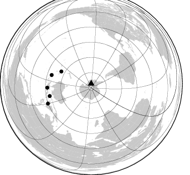
Nearby stations (2 deg radius)

| Station | Name | (Lat, Lon) | Start / End | Elevation |
| UP2C | Up Stream 2 Center | (-81.80, -124.99) | 1995-12-03 / 2499-01-01 | 779 m |
| Crust2 Type: | NC,highly extended crust, 2 km ice, 0.5km sediments |
| Thickness Estimate: | 33 km |
| Thickness StdDev: | 16 km |
| Vp/Vs Estimate: | 1.66 |
| Vp/Vs StdDev: | 0.13 |
| Vs Estimate: | 3.661 km/s |
| Poisson's Ratio: | 0.22 |
| Peak Value: | 0.08 |
| Assumed Vp: | 6.095 km/s |
| Ps Weight: | 0.33333334 |
| PpPs Weight: | 0.33333334 |
| PsPs Weight: | 0.33333328 |
| Residual Complexity: | 0.662 |
| Nearby stations H: | +- |
| (2.0 deg) Vp/Vs: | +- |
1 with match > 90% ( 12.5 %) and 5 with match > 80% ( 62.5 %) out of 8.
Download stack as xyz text file.
Azimuth Distribution of Events:
Prior Results for this Station
| Study | Thickness | Vp/Vs | Vp | Vs | Poissons Ratio | Extra |
| EARS | 33 km | 1.66 | 6.095 km/s | 3.661 km/s | 0.22 | |
| Crust2.0 | 26 km | 1.78 | 6.095 km/s | 3.416 km/s | 0.27 | NC,highly extended crust, 2 km ice, 0.5km sediments |
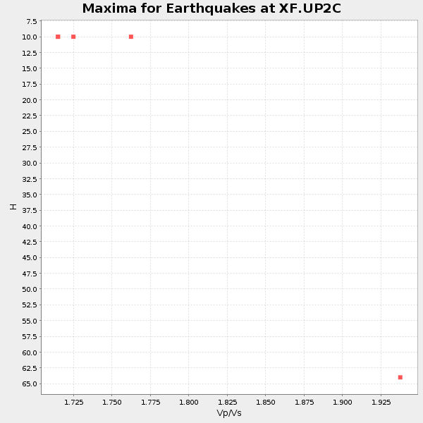
| Global Maxima | 33 km | 1.66 | 6.095 km/s | 3.661 km/s | 0.22 | amp=0.076512456 |
| Local Maxima 1 | 66 km | 1.90 | 6.095 km/s | 3.212 km/s | 0.31 | amp=0.069918945 |
| Local Maxima 2 | 69 km | 1.64 | 6.095 km/s | 3.722 km/s | 0.20 | amp=0.03927001 |
| Local Maxima 3 | 32 km | 1.86 | 6.095 km/s | 3.273 km/s | 0.30 | amp=0.029506627 |
| Local Maxima 4 | 65 km | 1.92 | 6.095 km/s | 3.17 km/s | 0.31 | amp=0.029250588 |
| Predicted Arrivals for vertical incidence (zero ray parameter) | |
| Ps | 3.63 SECOND |
| PpPs | 14.54 SECOND |
| PsPs/PpSs | 18.17 SECOND |
Events Processed for this Station
Download zip of receiver functions as SAC
Plot maxima for each earthquake.
Events Used in the Stack
(5 events)| Radial Match | Distance | Baz | FERegion | Time | Lat/Lon | Depth | Magnitude |
| 90.96295 | 87.0 deg | 264.779 deg | Irian Jaya, Indonesia | 1995/12/19 23:28:12 GMT | (-3.7, 140.3) | 71 km | 6.2 MB, 6.5 UNKNOWN |
| 86.58698 | 79.8 deg | 282.313 deg | Solomon Islands | 1996/01/11 03:51:34 GMT | (-8.4, 158.6) | 96 km | 5.5 MB, 5.6 UNKNOWN, 5.9 MW |
| 85.75883 | 85.4 deg | 253.369 deg | Banda Sea | 1995/12/25 04:43:24 GMT | (-6.9, 129.2) | 150 km | 6.2 MB, 7.1 UNKNOWN, 7.1 MW |
| 83.21718 | 94.2 deg | 245.29 deg | Minahassa Peninsula, Sulawesi | 1996/01/01 08:05:11 GMT | (0.7, 120.0) | 33 km | 6.2 MB, 7.7 MS, 7.8 UNKNOWN, 7.8 MW |
| 80.06531 | 63.6 deg | 292.278 deg | Southeast Of Loyalty Islands | 1996/01/12 02:17:34 GMT | (-23.2, 170.8) | 33 km | 5.8 MB, 5.5 MS, 5.5 UNKNOWN, 6.0 MW |
Losers
(3 events)| Radial Match | Distance | Baz | FERegion | Time | Lat/Lon | Depth | Magnitude | Reason |
| 82.12495 | 84.0 deg | 275.631 deg | New Britain Region, P.N.G. | 1995/12/26 21:55:20 GMT | (-5.2, 151.4) | 33 km | 5.8 UNKNOWN, 5.4 MS, 5.4 MB | |
| 75.21521 | 63.6 deg | 307.357 deg | Tonga Islands | 1995/12/26 16:55:19 GMT | (-21.4, -174.8) | 33 km | 5.4 MB, 5.9 MS, 5.9 UNKNOWN, 5.7 MW | |
| 62.131237 | 66.5 deg | 304.972 deg | Fiji Islands Region | 1996/01/16 05:15:27 GMT | (-18.7, -177.5) | 334 km | 5.7 UNKNOWN, 5.4 MB |
