
Station XG RUB02 - Rupal Valley Broadband 2
Network: XG95 - Nanga Parbat Pakistan
Nearby stations (2 deg radius)
| Station | Name | (Lat, Lon) | Start / End | Elevation |
| RUB02 | Rupal Valley Broadband 2 | (35.24, 74.73) | 1995-09-10 / 1996-12-31 | 2900 m |
| Crust2 Type: | R2,orogen/65km Bolivia, 0.5 km seds. |
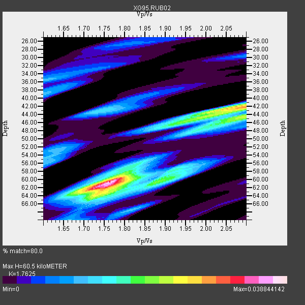
| Thickness Estimate: | 60 km |
| Thickness StdDev: | 6.9 km |
| Vp/Vs Estimate: | 1.76 |
| Vp/Vs StdDev: | 0.13 |
| Vs Estimate: | 3.677 km/s |
| Poisson's Ratio: | 0.26 |
| Peak Value: | 0.04 |
| Assumed Vp: | 6.481 km/s |
| Ps Weight: | 0.33333334 |
| PpPs Weight: | 0.33333334 |
| PsPs Weight: | 0.33333328 |
| Residual Complexity: | 0.749 |
| Nearby stations H: | +- |
| (2.0 deg) Vp/Vs: | +- |
1 with match > 90% ( 2.631579 %) and 8 with match > 80% ( 21.052631 %) out of 38.
Download stack as xyz text file.
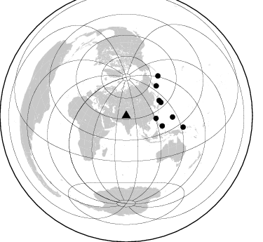
Azimuth Distribution of Events:
Prior Results for this Station
| Study | Thickness | Vp/Vs | Vp | Vs | Poissons Ratio | Extra |
| EARS | 60 km | 1.76 | 6.481 km/s | 3.677 km/s | 0.26 | |
| Crust2.0 | 65 km | 1.76 | 6.481 km/s | 3.685 km/s | 0.26 | R2,orogen/65km Bolivia, 0.5 km seds. |
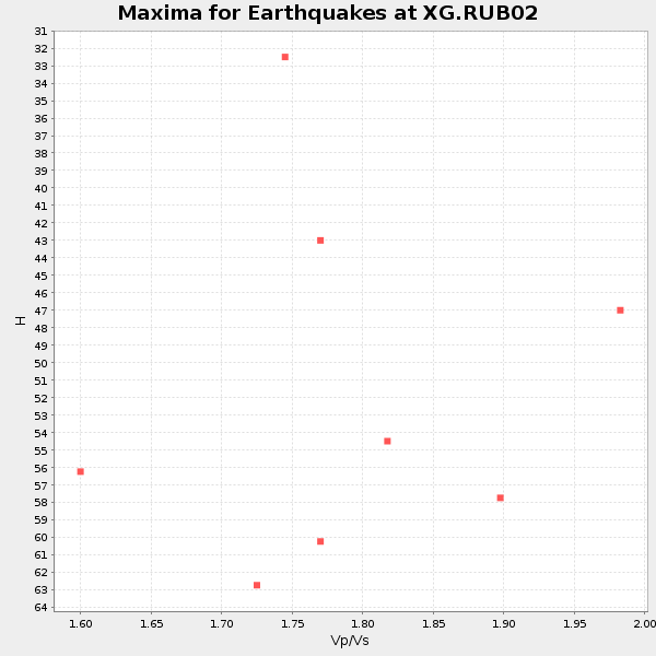
| Global Maxima | 60 km | 1.76 | 6.481 km/s | 3.677 km/s | 0.26 | amp=0.038844142 |
| Local Maxima 1 | 42 km | 2.10 | 6.481 km/s | 3.09 km/s | 0.35 | amp=0.027732458 |
| Local Maxima 2 | 60 km | 1.88 | 6.481 km/s | 3.447 km/s | 0.30 | amp=0.019770017 |
| Local Maxima 3 | 44 km | 2.10 | 6.481 km/s | 3.09 km/s | 0.35 | amp=0.019135078 |
| Local Maxima 4 | 46 km | 1.95 | 6.481 km/s | 3.319 km/s | 0.32 | amp=0.015700886 |
| Predicted Arrivals for vertical incidence (zero ray parameter) | |
| Ps | 7.12 SECOND |
| PpPs | 25.79 SECOND |
| PsPs/PpSs | 32.91 SECOND |
Events Processed for this Station
Download zip of receiver functions as SAC
Plot maxima for each earthquake.
Events Used in the Stack
(8 events)| Radial Match | Distance | Baz | FERegion | Time | Lat/Lon | Depth | Magnitude |
| 92.241356 | 51.6 deg | 65.234 deg | Eastern Honshu, Japan | 1996/08/10 18:12:17 GMT | (38.9, 140.5) | 10 km | 6.0 MB, 5.7 MS, 5.9 UNKNOWN, 5.9 MW |
| 89.67023 | 53.0 deg | 69.12 deg | Near East Coast Of Honshu, Japan | 1996/09/11 02:37:14 GMT | (35.5, 140.9) | 55 km | 6.1 MB, 5.7 MS, 6.2 UNKNOWN, 6.1 MW |
| 87.88177 | 42.8 deg | 95.227 deg | Taiwan Region | 1996/09/05 23:42:06 GMT | (21.9, 121.5) | 20 km | 6.4 MB, 6.6 MS, 6.8 UNKNOWN, 6.8 ME |
| 86.67544 | 66.0 deg | 91.689 deg | South Of Mariana Islands | 1996/09/02 20:41:52 GMT | (12.3, 143.8) | 33 km | 5.7 MB, 5.7 MS, 5.9 UNKNOWN, 5.8 MW |
| 85.89848 | 72.7 deg | 38.738 deg | Andreanof Islands, Aleutian Is. | 1996/06/08 23:19:15 GMT | (51.5, -178.1) | 33 km | 5.9 MB, 6.3 MS, 6.5 UNKNOWN, 6.1 MS |
| 82.19556 | 53.4 deg | 105.802 deg | Mindanao, Philippines | 1996/09/20 04:10:27 GMT | (9.5, 126.3) | 33 km | 5.8 MB, 6.4 MS, 6.6 UNKNOWN, 6.6 MW |
| 81.58999 | 60.4 deg | 45.437 deg | Off East Coast Of Kamchatka | 1996/06/30 11:32:35 GMT | (51.7, 159.8) | 33 km | 5.5 MB, 5.9 MS, 6.1 UNKNOWN, 6.0 MW |
| 81.18633 | 82.6 deg | 101.33 deg | New Britain Region, P.N.G. | 1996/08/10 11:20:19 GMT | (-4.9, 152.1) | 33 km | 5.6 MB, 6.0 MS, 6.2 UNKNOWN, 6.1 MW |
Losers
(30 events)| Radial Match | Distance | Baz | FERegion | Time | Lat/Lon | Depth | Magnitude | Reason |
| 88.82833 | 54.5 deg | 118.385 deg | Minahassa Peninsula, Sulawesi | 1996/07/22 14:19:35 GMT | (1.0, 120.4) | 33 km | 6.0 MB, 6.9 MS, 7.0 UNKNOWN, 6.9 MW | |
| 87.78922 | 60.3 deg | 45.78 deg | Off East Coast Of Kamchatka | 1996/07/18 22:55:03 GMT | (51.5, 159.4) | 33 km | 5.5 MB, 5.2 MS | |
| 87.40107 | 64.1 deg | 84.702 deg | Mariana Islands | 1996/07/15 16:51:22 GMT | (18.7, 145.6) | 177 km | 5.9 MB, 6.3 UNKNOWN, 6.3 MW | |
| 86.06681 | 52.8 deg | 60.931 deg | Hokkaido, Japan Region | 1995/09/26 07:14:37 GMT | (41.8, 143.4) | 36 km | 5.7 MB, 5.5 MS, 5.9 UNKNOWN, 5.8 MW | |
| 85.01818 | 49.1 deg | 140.042 deg | Southern Sumatra, Indonesia | 1995/09/23 16:05:50 GMT | (-5.7, 103.9) | 56 km | 5.8 MB, 6.2 UNKNOWN, 6.0 MW | |
| 84.69795 | 85.9 deg | 100.593 deg | Solomon Islands | 1995/09/16 01:03:38 GMT | (-6.3, 155.3) | 160 km | 5.8 MB, 6.1 UNKNOWN, 6.1 MW | |
| 84.536995 | 87.0 deg | 101.03 deg | Solomon Islands | 1996/09/06 17:03:46 GMT | (-7.3, 155.9) | 33 km | 5.6 MB, 6.1 MS, 6.3 UNKNOWN, 6.2 MW | |
| 84.48368 | 35.6 deg | 288.015 deg | Turkey | 1995/10/01 15:57:16 GMT | (38.1, 30.2) | 33 km | 5.7 MB, 6.1 MS, 6.3 UNKNOWN, 6.0 MW | |
| 81.485916 | 86.9 deg | 101.035 deg | Solomon Islands | 1996/09/06 12:39:41 GMT | (-7.3, 155.8) | 33 km | 5.5 MB, 5.8 MS, 5.9 UNKNOWN, 5.9 MW | |
| 79.50639 | 78.8 deg | 105.57 deg | Eastern New Guinea Reg., P.N.G. | 1995/09/22 05:39:29 GMT | (-6.0, 146.5) | 33 km | 5.7 MB, 6.0 MS, 6.2 UNKNOWN | |
| 79.267876 | 76.6 deg | 175.613 deg | Mid-Indian Ridge | 1996/08/19 06:24:11 GMT | (-41.5, 80.4) | 10 km | 5.4 MB, 5.9 MS, 6.0 UNKNOWN, 5.9 MW | |
| 79.129364 | 62.2 deg | 122.741 deg | Banda Sea | 1996/08/22 05:35:42 GMT | (-7.1, 123.3) | 596 km | 5.8 MB, 5.9 UNKNOWN, 5.8 MW | |
| 78.24889 | 59.3 deg | 47.019 deg | Kuril Islands | 1995/09/30 10:47:56 GMT | (50.8, 157.4) | 33 km | 5.7 MB, 5.5 MS | |
| 77.69123 | 53.3 deg | 105.663 deg | Mindanao, Philippines | 1996/09/20 00:03:18 GMT | (9.6, 126.3) | 33 km | 5.8 MB, 6.2 MS, 6.4 UNKNOWN, 6.4 MW | |
| 77.54188 | 53.8 deg | 77.07 deg | Southeast Of Honshu, Japan | 1995/10/01 17:06:03 GMT | (29.3, 139.0) | 427 km | 5.5 MB, 5.8 UNKNOWN, 6.1 MW | |
| 75.18973 | 51.5 deg | 103.709 deg | Samar, Philippines | 1996/08/08 23:12:35 GMT | (12.0, 125.7) | 33 km | 5.5 MS, 5.4 MB | |
| 75.17027 | 52.8 deg | 189.736 deg | Mauritius - Reunion Region | 1995/09/17 17:09:20 GMT | (-17.2, 66.6) | 10 km | 5.4 MB, 6.3 MS, 6.5 UNKNOWN, 6.3 MW | |
| 74.453415 | 78.9 deg | 105.549 deg | Eastern New Guinea Reg., P.N.G. | 1995/09/23 02:34:16 GMT | (-6.0, 146.6) | 60 km | 5.8 MB, 6.0 UNKNOWN, 5.8 MW | |
| 74.07519 | 54.3 deg | 118.538 deg | Minahassa Peninsula, Sulawesi | 1996/07/16 10:07:36 GMT | (1.0, 120.3) | 33 km | 6.0 MB, 6.4 MS, 6.6 UNKNOWN, 6.6 MW | |
| 73.33461 | 53.5 deg | 105.774 deg | Mindanao, Philippines | 1996/09/20 04:11:04 GMT | (9.5, 126.3) | 33 km | 5.9 MB | |
| 70.648705 | 66.0 deg | 118.237 deg | Banda Sea | 1995/09/18 06:56:31 GMT | (-6.9, 128.9) | 180 km | 5.5 MB | |
| 70.04243 | 54.3 deg | 118.597 deg | Minahassa Peninsula, Sulawesi | 1996/07/28 10:40:43 GMT | (1.0, 120.2) | 33 km | 5.5 MB, 5.5 MS, 6.0 UNKNOWN, 5.9 MW | |
| 69.179306 | 58.7 deg | 115.675 deg | Southern Molucca Sea | 1996/08/12 17:00:27 GMT | (-0.3, 125.1) | 42 km | 5.7 MB, 5.5 MS, 6.1 UNKNOWN, 6.0 MW | |
| 67.04012 | 55.3 deg | 46.583 deg | Sea Of Okhotsk | 1996/08/30 21:13:41 GMT | (52.3, 151.5) | 580 km | 5.5 UNKNOWN, 5.1 MB, 5.4 MW | |
| 66.22442 | 46.4 deg | 105.472 deg | Mindoro, Philippines | 1996/07/20 09:14:04 GMT | (13.9, 120.7) | 110 km | 5.5 MB, 5.9 UNKNOWN, 5.9 MW | |
| 65.791725 | 97.2 deg | 98.174 deg | Santa Cruz Islands | 1996/09/14 13:10:53 GMT | (-10.9, 166.0) | 73 km | 6.0 MB, 6.0 MS, 6.4 UNKNOWN, 6.4 MW | |
| 60.331387 | 57.0 deg | 117.193 deg | Minahassa Peninsula, Sulawesi | 1996/08/01 04:08:23 GMT | (-0.0, 122.9) | 149 km | 5.5 MB, 5.6 UNKNOWN, 5.5 MW | |
| 60.020996 | 45.5 deg | 105.299 deg | Luzon, Philippines | 1996/07/30 17:38:30 GMT | (14.5, 120.0) | 33 km | 6.1 MB, 5.7 MS, 6.1 UNKNOWN, 5.9 MW | |
| 59.60726 | 65.6 deg | 115.25 deg | Banda Sea | 1995/09/25 09:13:27 GMT | (-4.7, 130.5) | 33 km | 5.5 MB, 5.2 MS, 5.8 UNKNOWN, 5.8 MW | |
| 52.249535 | 56.8 deg | 117.301 deg | Minahassa Peninsula, Sulawesi | 1996/09/14 02:53:24 GMT | (-0.0, 122.8) | 181 km | 5.5 MB |
