
Station XG RUB03 - Eid Gah / Astor
Network: XG95 - Nanga Parbat Pakistan
Nearby stations (2 deg radius)
| Station | Name | (Lat, Lon) | Start / End | Elevation |
| RUB03 | Eid Gah / Astor | (35.34, 74.85) | 1996-05-30 / 1996-12-31 | 2365 m |
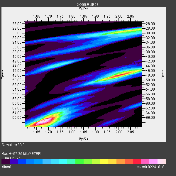
| Crust2 Type: | R2,orogen/65km Bolivia, 0.5 km seds. |
| Thickness Estimate: | 67 km |
| Thickness StdDev: | 16 km |
| Vp/Vs Estimate: | 1.68 |
| Vp/Vs StdDev: | 0.18 |
| Vs Estimate: | 3.852 km/s |
| Poisson's Ratio: | 0.23 |
| Peak Value: | 0.02 |
| Assumed Vp: | 6.481 km/s |
| Ps Weight: | 0.33333334 |
| PpPs Weight: | 0.33333334 |
| PsPs Weight: | 0.33333328 |
| Residual Complexity: | 0.784 |
| Nearby stations H: | +- |
| (2.0 deg) Vp/Vs: | +- |
2 with match > 90% ( 9.090909 %) and 13 with match > 80% ( 59.090908 %) out of 22.
Download stack as xyz text file.
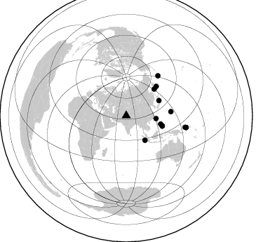
Azimuth Distribution of Events:
Prior Results for this Station
| Study | Thickness | Vp/Vs | Vp | Vs | Poissons Ratio | Extra |
| EARS | 67 km | 1.68 | 6.481 km/s | 3.852 km/s | 0.23 | |
| Crust2.0 | 65 km | 1.76 | 6.481 km/s | 3.685 km/s | 0.26 | R2,orogen/65km Bolivia, 0.5 km seds. |
| Global Maxima | 67 km | 1.68 | 6.481 km/s | 3.852 km/s | 0.23 | amp=0.02241818 |
| Local Maxima 1 | 48 km | 2.01 | 6.481 km/s | 3.22 km/s | 0.34 | amp=0.017948056 |
| Local Maxima 2 | 29 km | 2.06 | 6.481 km/s | 3.154 km/s | 0.34 | amp=0.015026265 |
| Local Maxima 3 | 68 km | 1.70 | 6.481 km/s | 3.818 km/s | 0.23 | amp=0.012392102 |
| Local Maxima 4 | 44 km | 1.74 | 6.481 km/s | 3.725 km/s | 0.25 | amp=0.009380124 |
| Predicted Arrivals for vertical incidence (zero ray parameter) | |
| Ps | 7.08 SECOND |
| PpPs | 27.84 SECOND |
| PsPs/PpSs | 34.92 SECOND |
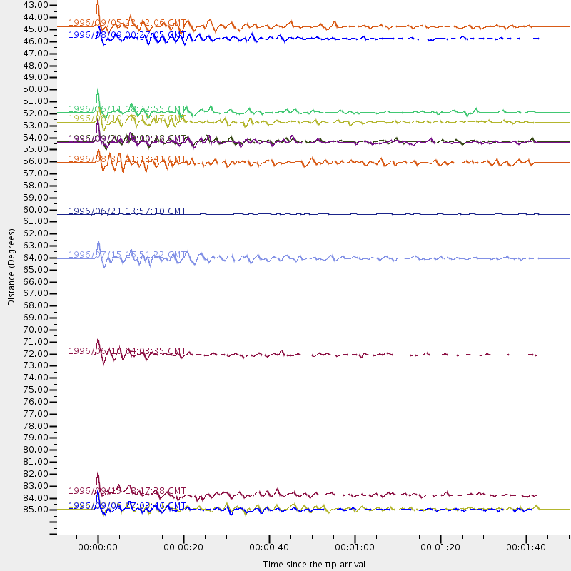
Events Processed for this Station
Download zip of receiver functions as SAC
Plot maxima for each earthquake.
Events Used in the Stack
(13 events)| Radial Match | Distance | Baz | FERegion | Time | Lat/Lon | Depth | Magnitude |
| 94.87595 | 72.8 deg | 38.554 deg | Andreanof Islands, Aleutian Is. | 1996/06/10 04:03:35 GMT | (51.6, -177.6) | 33 km | 6.6 MB, 7.6 MS, 7.9 UNKNOWN, 7.4 MS |
| 92.751076 | 86.9 deg | 101.106 deg | Solomon Islands | 1996/09/06 17:03:46 GMT | (-7.3, 155.9) | 33 km | 5.6 MB, 6.1 MS, 6.3 UNKNOWN, 6.2 MW |
| 85.67246 | 43.8 deg | 142.708 deg | Southern Sumatra, Indonesia | 1996/08/09 00:27:05 GMT | (-2.0, 99.7) | 33 km | 5.5 MS, 5.4 MB, 5.8 UNKNOWN, 5.7 MW |
| 85.48935 | 53.3 deg | 105.825 deg | Mindanao, Philippines | 1996/09/20 00:03:18 GMT | (9.6, 126.3) | 33 km | 5.8 MB, 6.2 MS, 6.4 UNKNOWN, 6.4 MW |
| 85.18748 | 53.4 deg | 105.964 deg | Mindanao, Philippines | 1996/09/20 04:10:27 GMT | (9.5, 126.3) | 33 km | 5.8 MB, 6.4 MS, 6.6 UNKNOWN, 6.6 MW |
| 84.46249 | 51.5 deg | 65.344 deg | Eastern Honshu, Japan | 1996/08/10 18:12:17 GMT | (38.9, 140.5) | 10 km | 6.0 MB, 5.7 MS, 5.9 UNKNOWN, 5.9 MW |
| 84.17861 | 64.0 deg | 84.816 deg | Mariana Islands | 1996/07/15 16:51:22 GMT | (18.7, 145.6) | 177 km | 5.9 MB, 6.3 UNKNOWN, 6.3 MW |
| 84.0624 | 85.6 deg | 101.082 deg | Solomon Islands | 1996/09/15 18:17:38 GMT | (-6.5, 154.8) | 50 km | 5.7 MB, 5.8 MS, 5.9 UNKNOWN, 5.9 MW |
| 81.19849 | 86.9 deg | 101.111 deg | Solomon Islands | 1996/09/06 12:39:41 GMT | (-7.3, 155.8) | 33 km | 5.5 MB, 5.8 MS, 5.9 UNKNOWN, 5.9 MW |
| 80.815834 | 59.9 deg | 45.851 deg | Off East Coast Of Kamchatka | 1996/06/21 13:57:10 GMT | (51.6, 159.1) | 20 km | 6.0 MB, 6.6 MS, 7.0 UNKNOWN, 6.5 MS |
| 80.685036 | 55.2 deg | 46.656 deg | Sea Of Okhotsk | 1996/08/30 21:13:41 GMT | (52.3, 151.5) | 580 km | 5.5 UNKNOWN, 5.1 MB, 5.4 MW |
| 80.59611 | 50.6 deg | 103.597 deg | Samar, Philippines | 1996/06/11 18:22:55 GMT | (12.6, 125.2) | 33 km | 6.0 MB, 7.0 MS, 7.2 UNKNOWN, 7.1 MW |
| 80.373436 | 42.7 deg | 95.415 deg | Taiwan Region | 1996/09/05 23:42:06 GMT | (21.9, 121.5) | 20 km | 6.4 MB, 6.6 MS, 6.8 UNKNOWN, 6.8 ME |
Losers
(9 events)| Radial Match | Distance | Baz | FERegion | Time | Lat/Lon | Depth | Magnitude | Reason |
| 78.51751 | 97.1 deg | 98.229 deg | Santa Cruz Islands | 1996/09/14 13:10:53 GMT | (-10.9, 166.0) | 73 km | 6.0 MB, 6.0 MS, 6.4 UNKNOWN, 6.4 MW | |
| 78.32402 | 54.3 deg | 118.706 deg | Minahassa Peninsula, Sulawesi | 1996/07/16 10:07:36 GMT | (1.0, 120.3) | 33 km | 6.0 MB, 6.4 MS, 6.6 UNKNOWN, 6.6 MW | |
| 78.05865 | 46.0 deg | 84.334 deg | Ryukyu Islands, Japan | 1996/06/02 09:37:46 GMT | (27.4, 128.5) | 42 km | 5.8 MB, 5.2 MS, 5.8 UNKNOWN, 5.8 MW | |
| 76.5145 | 53.4 deg | 105.936 deg | Mindanao, Philippines | 1996/09/20 04:11:04 GMT | (9.5, 126.3) | 33 km | 5.9 MB | |
| 74.0924 | 52.9 deg | 69.234 deg | Near East Coast Of Honshu, Japan | 1996/09/11 02:37:14 GMT | (35.5, 140.9) | 55 km | 6.1 MB, 5.7 MS, 6.2 UNKNOWN, 6.1 MW | |
| 69.212204 | 45.4 deg | 105.491 deg | Luzon, Philippines | 1996/07/30 17:38:30 GMT | (14.5, 120.0) | 33 km | 6.1 MB, 5.7 MS, 6.1 UNKNOWN, 5.9 MW | |
| 67.577034 | 56.8 deg | 117.459 deg | Minahassa Peninsula, Sulawesi | 1996/09/14 02:53:24 GMT | (-0.0, 122.8) | 181 km | 5.5 MB | |
| 65.09819 | 61.7 deg | 123.453 deg | Flores Sea | 1996/06/17 11:22:18 GMT | (-7.1, 122.6) | 587 km | 6.6 MB, 7.9 UNKNOWN, 7.8 MW | |
| 61.257103 | 53.6 deg | 105.592 deg | Mindanao, Philippines | 1996/09/20 19:24:57 GMT | (9.6, 126.6) | 33 km | 5.5 MB, 5.6 MS, 5.9 UNKNOWN, 5.8 MW |
