
Station XG RUB04 - Makial
Network: XG95 - Nanga Parbat Pakistan
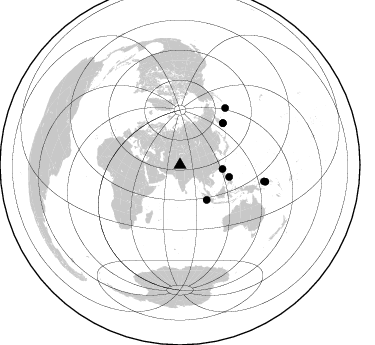
Nearby stations (2 deg radius)
| Station | Name | (Lat, Lon) | Start / End | Elevation |
| RUB04 | Makial | (35.26, 74.86) | 1996-05-31 / 1996-12-31 | 2454 m |
| Crust2 Type: | R2,orogen/65km Bolivia, 0.5 km seds. |
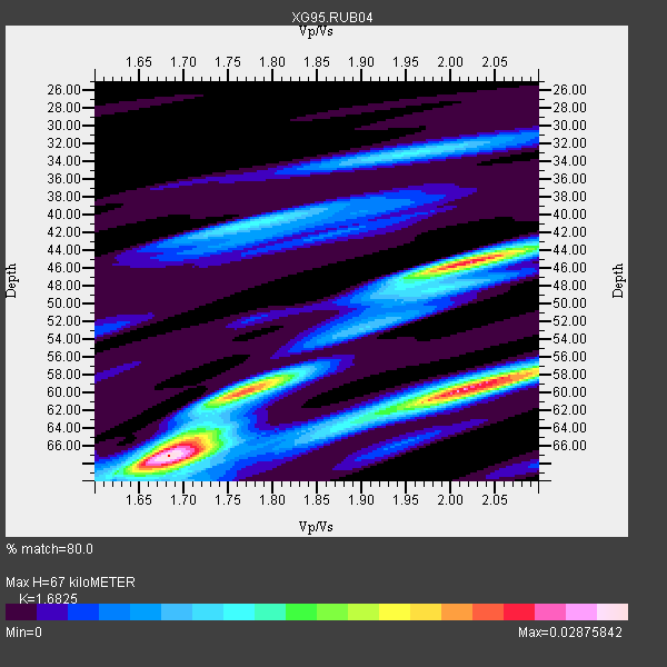
| Thickness Estimate: | 67 km |
| Thickness StdDev: | 8.8 km |
| Vp/Vs Estimate: | 1.68 |
| Vp/Vs StdDev: | 0.16 |
| Vs Estimate: | 3.852 km/s |
| Poisson's Ratio: | 0.23 |
| Peak Value: | 0.03 |
| Assumed Vp: | 6.481 km/s |
| Ps Weight: | 0.33333334 |
| PpPs Weight: | 0.33333334 |
| PsPs Weight: | 0.33333328 |
| Residual Complexity: | 0.742 |
| Nearby stations H: | +- |
| (2.0 deg) Vp/Vs: | +- |
1 with match > 90% ( 5.0 %) and 8 with match > 80% ( 40.0 %) out of 20.
Download stack as xyz text file.
Azimuth Distribution of Events:
Prior Results for this Station
| Study | Thickness | Vp/Vs | Vp | Vs | Poissons Ratio | Extra |
| EARS | 67 km | 1.68 | 6.481 km/s | 3.852 km/s | 0.23 | |
| Crust2.0 | 65 km | 1.76 | 6.481 km/s | 3.685 km/s | 0.26 | R2,orogen/65km Bolivia, 0.5 km seds. |
| Global Maxima | 67 km | 1.68 | 6.481 km/s | 3.852 km/s | 0.23 | amp=0.02875842 |
| Local Maxima 1 | 45 km | 2.02 | 6.481 km/s | 3.204 km/s | 0.34 | amp=0.023601871 |
| Local Maxima 2 | 59 km | 2.04 | 6.481 km/s | 3.177 km/s | 0.34 | amp=0.01938381 |
| Local Maxima 3 | 60 km | 1.76 | 6.481 km/s | 3.677 km/s | 0.26 | amp=0.01449931 |
| Local Maxima 4 | 41 km | 1.77 | 6.481 km/s | 3.651 km/s | 0.27 | amp=0.0108775655 |
| Predicted Arrivals for vertical incidence (zero ray parameter) | |
| Ps | 7.06 SECOND |
| PpPs | 27.73 SECOND |
| PsPs/PpSs | 34.79 SECOND |
Events Processed for this Station
Download zip of receiver functions as SAC
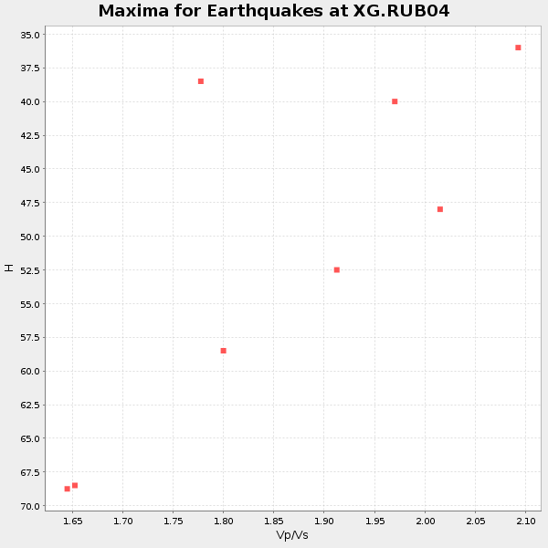
Plot maxima for each earthquake.
Events Used in the Stack
(8 events)| Radial Match | Distance | Baz | FERegion | Time | Lat/Lon | Depth | Magnitude |
| 93.02195 | 72.8 deg | 38.541 deg | Andreanof Islands, Aleutian Is. | 1996/06/10 04:03:35 GMT | (51.6, -177.6) | 33 km | 6.6 MB, 7.6 MS, 7.9 UNKNOWN, 7.4 MS |
| 88.301285 | 60.0 deg | 45.819 deg | Off East Coast Of Kamchatka | 1996/06/21 13:57:10 GMT | (51.6, 159.1) | 20 km | 6.0 MB, 6.6 MS, 7.0 UNKNOWN, 6.5 MS |
| 88.24058 | 86.9 deg | 101.107 deg | Solomon Islands | 1996/09/06 17:03:46 GMT | (-7.3, 155.9) | 33 km | 5.6 MB, 6.1 MS, 6.3 UNKNOWN, 6.2 MW |
| 87.007996 | 60.1 deg | 45.974 deg | Off East Coast Of Kamchatka | 1996/06/22 14:50:07 GMT | (51.4, 159.2) | 33 km | 5.6 MB, 6.0 MS, 6.2 UNKNOWN, 6.2 MW |
| 84.71407 | 50.6 deg | 103.538 deg | Samar, Philippines | 1996/06/11 18:22:55 GMT | (12.6, 125.2) | 33 km | 6.0 MB, 7.0 MS, 7.2 UNKNOWN, 7.1 MW |
| 84.57445 | 42.7 deg | 95.332 deg | Taiwan Region | 1996/09/05 23:42:06 GMT | (21.9, 121.5) | 20 km | 6.4 MB, 6.6 MS, 6.8 UNKNOWN, 6.8 ME |
| 84.17 | 43.8 deg | 142.668 deg | Southern Sumatra, Indonesia | 1996/08/09 00:27:05 GMT | (-2.0, 99.7) | 33 km | 5.5 MS, 5.4 MB, 5.8 UNKNOWN, 5.7 MW |
| 80.93679 | 85.6 deg | 101.082 deg | Solomon Islands | 1996/09/15 18:17:38 GMT | (-6.5, 154.8) | 50 km | 5.7 MB, 5.8 MS, 5.9 UNKNOWN, 5.9 MW |
Losers
(12 events)| Radial Match | Distance | Baz | FERegion | Time | Lat/Lon | Depth | Magnitude | Reason |
| 79.558945 | 46.0 deg | 84.26 deg | Ryukyu Islands, Japan | 1996/06/02 09:37:46 GMT | (27.4, 128.5) | 42 km | 5.8 MB, 5.2 MS, 5.8 UNKNOWN, 5.8 MW | |
| 78.67048 | 86.8 deg | 101.112 deg | Solomon Islands | 1996/09/06 12:39:41 GMT | (-7.3, 155.8) | 33 km | 5.5 MB, 5.8 MS, 5.9 UNKNOWN, 5.9 MW | |
| 78.596825 | 53.2 deg | 105.773 deg | Mindanao, Philippines | 1996/09/20 00:03:18 GMT | (9.6, 126.3) | 33 km | 5.8 MB, 6.2 MS, 6.4 UNKNOWN, 6.4 MW | |
| 76.76081 | 52.9 deg | 69.18 deg | Near East Coast Of Honshu, Japan | 1996/09/11 02:37:14 GMT | (35.5, 140.9) | 55 km | 6.1 MB, 5.7 MS, 6.2 UNKNOWN, 6.1 MW | |
| 75.39007 | 53.4 deg | 105.884 deg | Mindanao, Philippines | 1996/09/20 04:11:04 GMT | (9.5, 126.3) | 33 km | 5.9 MB | |
| 70.58562 | 54.2 deg | 118.662 deg | Minahassa Peninsula, Sulawesi | 1996/07/16 10:07:36 GMT | (1.0, 120.3) | 33 km | 6.0 MB, 6.4 MS, 6.6 UNKNOWN, 6.6 MW | |
| 69.937386 | 97.1 deg | 98.245 deg | Santa Cruz Islands | 1996/09/14 13:10:53 GMT | (-10.9, 166.0) | 73 km | 6.0 MB, 6.0 MS, 6.4 UNKNOWN, 6.4 MW | |
| 69.43911 | 56.8 deg | 117.419 deg | Minahassa Peninsula, Sulawesi | 1996/09/14 02:53:24 GMT | (-0.0, 122.8) | 181 km | 5.5 MB | |
| 69.085655 | 62.1 deg | 122.855 deg | Banda Sea | 1996/08/22 05:35:42 GMT | (-7.1, 123.3) | 596 km | 5.8 MB, 5.9 UNKNOWN, 5.8 MW | |
| 68.483 | 45.4 deg | 105.42 deg | Luzon, Philippines | 1996/07/30 17:38:30 GMT | (14.5, 120.0) | 33 km | 6.1 MB, 5.7 MS, 6.1 UNKNOWN, 5.9 MW | |
| 66.12207 | 55.3 deg | 46.616 deg | Sea Of Okhotsk | 1996/08/30 21:13:41 GMT | (52.3, 151.5) | 580 km | 5.5 UNKNOWN, 5.1 MB, 5.4 MW | |
| 56.40825 | 53.5 deg | 105.541 deg | Mindanao, Philippines | 1996/09/20 19:24:57 GMT | (9.6, 126.6) | 33 km | 5.5 MB, 5.6 MS, 5.9 UNKNOWN, 5.8 MW |
