
Station XG TTB02 - Tato tea house
Network: XG95 - Nanga Parbat Pakistan
Nearby stations (2 deg radius)
| Station | Name | (Lat, Lon) | Start / End | Elevation |
| TTB02 | Tato tea house | (35.41, 74.59) | 1996-06-06 / 1996-12-31 | 2601 m |
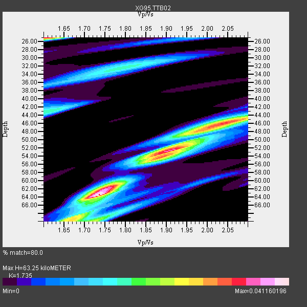
| Crust2 Type: | R2,orogen/65km Bolivia, 0.5 km seds. |
| Thickness Estimate: | 63 km |
| Thickness StdDev: | 7.7 km |
| Vp/Vs Estimate: | 1.74 |
| Vp/Vs StdDev: | 0.13 |
| Vs Estimate: | 3.735 km/s |
| Poisson's Ratio: | 0.25 |
| Peak Value: | 0.04 |
| Assumed Vp: | 6.481 km/s |
| Ps Weight: | 0.33333334 |
| PpPs Weight: | 0.33333334 |
| PsPs Weight: | 0.33333328 |
| Residual Complexity: | 0.808 |
| Nearby stations H: | +- |
| (2.0 deg) Vp/Vs: | +- |
1 with match > 90% ( 7.142857 %) and 6 with match > 80% ( 42.857143 %) out of 14.
Download stack as xyz text file.
Azimuth Distribution of Events:

Prior Results for this Station
| Study | Thickness | Vp/Vs | Vp | Vs | Poissons Ratio | Extra |
| EARS | 63 km | 1.74 | 6.481 km/s | 3.735 km/s | 0.25 | |
| Crust2.0 | 65 km | 1.76 | 6.481 km/s | 3.685 km/s | 0.26 | R2,orogen/65km Bolivia, 0.5 km seds. |
| Global Maxima | 63 km | 1.74 | 6.481 km/s | 3.735 km/s | 0.25 | amp=0.041160196 |
| Local Maxima 1 | 25 km | 1.60 | 6.481 km/s | 4.05 km/s | 0.18 | amp=0.034970425 |
| Local Maxima 2 | 52 km | 1.91 | 6.481 km/s | 3.393 km/s | 0.31 | amp=0.032732576 |
| Local Maxima 3 | 46 km | 2.06 | 6.481 km/s | 3.146 km/s | 0.35 | amp=0.027296064 |
| Local Maxima 4 | 70 km | 1.73 | 6.481 km/s | 3.757 km/s | 0.25 | amp=0.023131926 |
| Predicted Arrivals for vertical incidence (zero ray parameter) | |
| Ps | 7.17 SECOND |
| PpPs | 26.69 SECOND |
| PsPs/PpSs | 33.87 SECOND |
Events Processed for this Station
Download zip of receiver functions as SAC
Plot maxima for each earthquake.
Events Used in the Stack
(6 events)| Radial Match | Distance | Baz | FERegion | Time | Lat/Lon | Depth | Magnitude |
| 90.6374 | 72.8 deg | 38.467 deg | Andreanof Islands, Aleutian Is. | 1996/06/10 04:03:35 GMT | (51.6, -177.6) | 33 km | 6.6 MB, 7.6 MS, 7.9 UNKNOWN, 7.4 MS |
| 88.41405 | 50.8 deg | 103.46 deg | Samar, Philippines | 1996/06/11 18:22:55 GMT | (12.6, 125.2) | 33 km | 6.0 MB, 7.0 MS, 7.2 UNKNOWN, 7.1 MW |
| 85.85668 | 53.6 deg | 105.818 deg | Mindanao, Philippines | 1996/09/20 04:10:27 GMT | (9.5, 126.3) | 33 km | 5.8 MB, 6.4 MS, 6.6 UNKNOWN, 6.6 MW |
| 85.74114 | 60.0 deg | 45.815 deg | Off East Coast Of Kamchatka | 1996/06/21 13:57:10 GMT | (51.6, 159.1) | 20 km | 6.0 MB, 6.6 MS, 7.0 UNKNOWN, 6.5 MS |
| 80.69038 | 53.5 deg | 105.68 deg | Mindanao, Philippines | 1996/09/20 00:03:18 GMT | (9.6, 126.3) | 33 km | 5.8 MB, 6.2 MS, 6.4 UNKNOWN, 6.4 MW |
| 80.09454 | 53.6 deg | 105.79 deg | Mindanao, Philippines | 1996/09/20 04:11:04 GMT | (9.5, 126.3) | 33 km | 5.9 MB |
Losers
(8 events)| Radial Match | Distance | Baz | FERegion | Time | Lat/Lon | Depth | Magnitude | Reason |
| 83.23205 | 76.6 deg | 175.298 deg | Mid-Indian Ridge | 1996/06/06 17:35:38 GMT | (-41.3, 80.7) | 20 km | 5.5 MB, 5.9 MS, 6.3 UNKNOWN, 6.2 MW | |
| 77.00527 | 64.7 deg | 86.01 deg | Mariana Islands | 1996/06/09 01:12:16 GMT | (17.4, 145.5) | 149 km | 6.0 MB, 5.9 MS, 6.5 UNKNOWN, 6.5 MW | |
| 76.35204 | 72.5 deg | 38.842 deg | Andreanof Islands, Aleutian Is. | 1996/08/19 04:19:16 GMT | (51.5, -178.4) | 33 km | 5.7 MB, 5.6 MS, 6.0 UNKNOWN, 5.7 ML | |
| 70.57204 | 55.3 deg | 46.642 deg | Sea Of Okhotsk | 1996/08/30 21:13:41 GMT | (52.3, 151.5) | 580 km | 5.5 UNKNOWN, 5.1 MB, 5.4 MW | |
| 68.77373 | 51.6 deg | 103.737 deg | Samar, Philippines | 1996/08/08 23:12:35 GMT | (12.0, 125.7) | 33 km | 5.5 MS, 5.4 MB | |
| 64.9281 | 62.3 deg | 122.702 deg | Banda Sea | 1996/08/22 05:35:42 GMT | (-7.1, 123.3) | 596 km | 5.8 MB, 5.9 UNKNOWN, 5.8 MW | |
| 64.627594 | 45.6 deg | 105.349 deg | Luzon, Philippines | 1996/07/30 17:38:30 GMT | (14.5, 120.0) | 33 km | 6.1 MB, 5.7 MS, 6.1 UNKNOWN, 5.9 MW | |
| 53.731064 | 53.8 deg | 105.448 deg | Mindanao, Philippines | 1996/09/20 19:24:57 GMT | (9.6, 126.6) | 33 km | 5.5 MB, 5.6 MS, 5.9 UNKNOWN, 5.8 MW |
