
Station XG TTB03 - Lichar
Network: XG95 - Nanga Parbat Pakistan
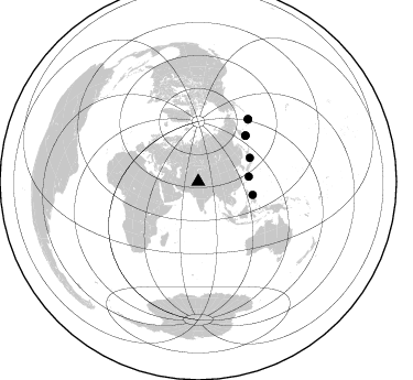
Nearby stations (2 deg radius)
| Station | Name | (Lat, Lon) | Start / End | Elevation |
| TTB03 | Lichar | (35.51, 74.63) | 1996-05-28 / 1996-12-31 | 1371 m |
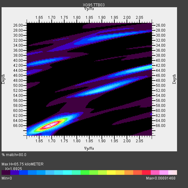
| Crust2 Type: | R2,orogen/65km Bolivia, 0.5 km seds. |
| Thickness Estimate: | 66 km |
| Thickness StdDev: | 0.6 km |
| Vp/Vs Estimate: | 1.69 |
| Vp/Vs StdDev: | 0.01 |
| Vs Estimate: | 3.829 km/s |
| Poisson's Ratio: | 0.23 |
| Peak Value: | 0.07 |
| Assumed Vp: | 6.481 km/s |
| Ps Weight: | 0.33333334 |
| PpPs Weight: | 0.33333334 |
| PsPs Weight: | 0.33333328 |
| Residual Complexity: | 0.521 |
| Nearby stations H: | +- |
| (2.0 deg) Vp/Vs: | +- |
1 with match > 90% ( 7.6923075 %) and 7 with match > 80% ( 53.846153 %) out of 13.
Download stack as xyz text file.
Azimuth Distribution of Events:
Prior Results for this Station
| Study | Thickness | Vp/Vs | Vp | Vs | Poissons Ratio | Extra |
| EARS | 66 km | 1.69 | 6.481 km/s | 3.829 km/s | 0.23 | |
| Crust2.0 | 65 km | 1.76 | 6.481 km/s | 3.685 km/s | 0.26 | R2,orogen/65km Bolivia, 0.5 km seds. |
| Global Maxima | 66 km | 1.69 | 6.481 km/s | 3.829 km/s | 0.23 | amp=0.06691468 |
| Local Maxima 1 | 42 km | 2.09 | 6.481 km/s | 3.108 km/s | 0.35 | amp=0.027987177 |
| Local Maxima 2 | 64 km | 1.73 | 6.481 km/s | 3.752 km/s | 0.25 | amp=0.020945352 |
| Local Maxima 3 | 67 km | 1.68 | 6.481 km/s | 3.863 km/s | 0.22 | amp=0.016527656 |
| Local Maxima 4 | 30 km | 1.95 | 6.481 km/s | 3.332 km/s | 0.32 | amp=0.015470287 |
| Predicted Arrivals for vertical incidence (zero ray parameter) | |
| Ps | 7.03 SECOND |
| PpPs | 27.32 SECOND |
| PsPs/PpSs | 34.34 SECOND |
Events Processed for this Station
Download zip of receiver functions as SAC
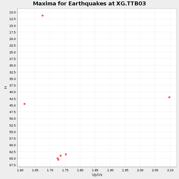
Plot maxima for each earthquake.
Events Used in the Stack
(7 events)| Radial Match | Distance | Baz | FERegion | Time | Lat/Lon | Depth | Magnitude |
| 90.92024 | 72.7 deg | 38.504 deg | Andreanof Islands, Aleutian Is. | 1996/06/10 04:03:35 GMT | (51.6, -177.6) | 33 km | 6.6 MB, 7.6 MS, 7.9 UNKNOWN, 7.4 MS |
| 89.40395 | 60.0 deg | 45.867 deg | Off East Coast Of Kamchatka | 1996/06/21 13:57:10 GMT | (51.6, 159.1) | 20 km | 6.0 MB, 6.6 MS, 7.0 UNKNOWN, 6.5 MS |
| 88.759995 | 51.6 deg | 65.398 deg | Eastern Honshu, Japan | 1996/08/10 18:12:17 GMT | (38.9, 140.5) | 10 km | 6.0 MB, 5.7 MS, 5.9 UNKNOWN, 5.9 MW |
| 82.847496 | 72.5 deg | 38.754 deg | Andreanof Islands, Aleutian Is. | 1996/06/08 23:19:15 GMT | (51.5, -178.1) | 33 km | 5.9 MB, 6.3 MS, 6.5 UNKNOWN, 6.1 MS |
| 82.78514 | 60.1 deg | 46.021 deg | Off East Coast Of Kamchatka | 1996/06/22 14:50:07 GMT | (51.4, 159.2) | 33 km | 5.6 MB, 6.0 MS, 6.2 UNKNOWN, 6.2 MW |
| 81.98539 | 50.8 deg | 103.571 deg | Samar, Philippines | 1996/06/11 18:22:55 GMT | (12.6, 125.2) | 33 km | 6.0 MB, 7.0 MS, 7.2 UNKNOWN, 7.1 MW |
| 80.91069 | 46.2 deg | 84.386 deg | Ryukyu Islands, Japan | 1996/06/02 09:37:46 GMT | (27.4, 128.5) | 42 km | 5.8 MB, 5.2 MS, 5.8 UNKNOWN, 5.8 MW |
Losers
(6 events)| Radial Match | Distance | Baz | FERegion | Time | Lat/Lon | Depth | Magnitude | Reason |
| 87.20762 | 76.7 deg | 175.335 deg | Mid-Indian Ridge | 1996/06/06 17:35:38 GMT | (-41.3, 80.7) | 20 km | 5.5 MB, 5.9 MS, 6.3 UNKNOWN, 6.2 MW | |
| 74.63886 | 76.8 deg | 175.544 deg | Mid-Indian Ridge | 1996/08/19 06:24:11 GMT | (-41.5, 80.4) | 10 km | 5.4 MB, 5.9 MS, 6.0 UNKNOWN, 5.9 MW | |
| 73.97283 | 62.4 deg | 122.782 deg | Banda Sea | 1996/08/22 05:35:42 GMT | (-7.1, 123.3) | 596 km | 5.8 MB, 5.9 UNKNOWN, 5.8 MW | |
| 72.35792 | 44.1 deg | 142.542 deg | Southern Sumatra, Indonesia | 1996/08/09 00:27:05 GMT | (-2.0, 99.7) | 33 km | 5.5 MS, 5.4 MB, 5.8 UNKNOWN, 5.7 MW | |
| 72.288536 | 45.6 deg | 105.477 deg | Luzon, Philippines | 1996/07/30 17:38:30 GMT | (14.5, 120.0) | 33 km | 6.1 MB, 5.7 MS, 6.1 UNKNOWN, 5.9 MW | |
| 61.875153 | 55.2 deg | 46.7 deg | Sea Of Okhotsk | 1996/08/30 21:13:41 GMT | (52.3, 151.5) | 580 km | 5.5 UNKNOWN, 5.1 MB, 5.4 MW |
