
Station XH RS12 - Ross Ice Shelf - RS12
Network: XH14 - Dynamic Response of the Ross Ice Shelf to Ocean Waves and Structure and Dynamics
Nearby stations (2 deg radius)
| Station | Name | (Lat, Lon) | Start / End | Elevation |
| RS12 | Ross Ice Shelf - RS12 | (-79.02, -147.63) | 2014-11-21 / 2017-02-05 | 3.0 m |
| Crust2 Type: | N1,highly extended crust, 1 km ice, 0.5 km seds |
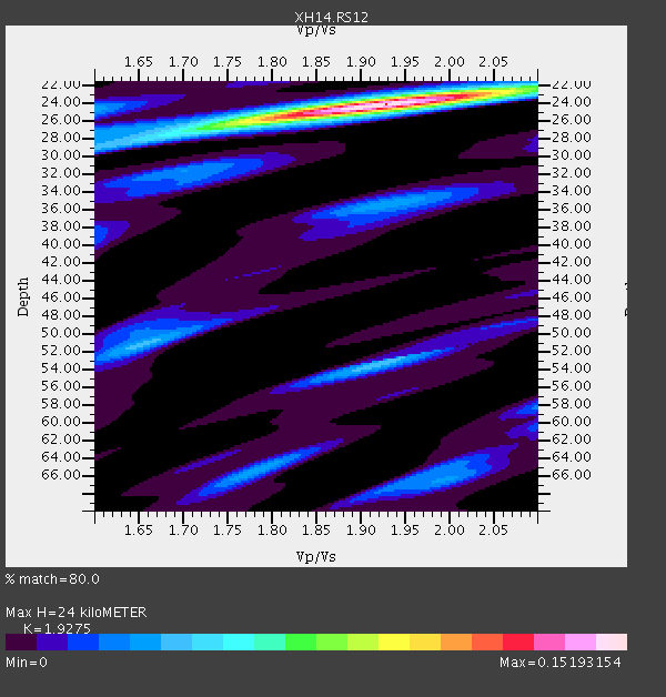
| Thickness Estimate: | 24 km |
| Thickness StdDev: | 0.2 km |
| Vp/Vs Estimate: | 1.93 |
| Vp/Vs StdDev: | 0.02 |
| Vs Estimate: | 3.207 km/s |
| Poisson's Ratio: | 0.32 |
| Peak Value: | 0.15 |
| Assumed Vp: | 6.182 km/s |
| Ps Weight: | 0.33333334 |
| PpPs Weight: | 0.33333334 |
| PsPs Weight: | 0.33333328 |
| Residual Complexity: | 0.405 |
| Nearby stations H: | +- |
| (2.0 deg) Vp/Vs: | +- |
2 with match > 90% ( 33.333332 %) and 2 with match > 80% ( 33.333332 %) out of 6.
Download stack as xyz text file.
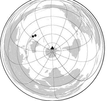
Azimuth Distribution of Events:
Prior Results for this Station
| Study | Thickness | Vp/Vs | Vp | Vs | Poissons Ratio | Extra |
| EARS | 24 km | 1.93 | 6.182 km/s | 3.207 km/s | 0.32 | |
| Crust2.0 | 26 km | 1.78 | 6.182 km/s | 3.475 km/s | 0.27 | N1,highly extended crust, 1 km ice, 0.5 km seds |
| Global Maxima | 24 km | 1.93 | 6.182 km/s | 3.207 km/s | 0.32 | amp=0.15193154 |
| Local Maxima 1 | 53 km | 1.92 | 6.182 km/s | 3.22 km/s | 0.31 | amp=0.04191604 |
| Local Maxima 2 | 51 km | 1.65 | 6.182 km/s | 3.735 km/s | 0.21 | amp=0.04096711 |
| Local Maxima 3 | 27 km | 1.73 | 6.182 km/s | 3.583 km/s | 0.25 | amp=0.039473552 |
| Local Maxima 4 | 35 km | 1.93 | 6.182 km/s | 3.207 km/s | 0.32 | amp=0.035879273 |
| Predicted Arrivals for vertical incidence (zero ray parameter) | |
| Ps | 3.60 SECOND |
| PpPs | 11.37 SECOND |
| PsPs/PpSs | 14.97 SECOND |
Events Processed for this Station
Download zip of receiver functions as SAC
Plot maxima for each earthquake.
Events Used in the Stack
(2 events)| Radial Match | Distance | Baz | FERegion | Time | Lat/Lon | Depth | Magnitude |
| 96.77294 | 78.0 deg | 301.247 deg | Solomon Islands | 2017/01/22 04:30:23 GMT | (-6.2, 155.1) | 136 km | 7.9 mww |
| 95.66223 | 72.9 deg | 306.78 deg | Solomon Islands | 2017/01/19 23:04:20 GMT | (-10.4, 161.3) | 34 km | 6.8 mwp |
Losers
(4 events)| Radial Match | Distance | Baz | FERegion | Time | Lat/Lon | Depth | Magnitude | Reason |
| 85.626434 | 67.7 deg | 312.094 deg | Vanuatu Islands | 2017/01/30 23:35:23 GMT | (-14.8, 167.2) | 78 km | 5.8 Mwp | |
| 77.05804 | 50.7 deg | 326.102 deg | Kermadec Islands, New Zealand | 2017/01/29 14:59:51 GMT | (-30.1, -177.5) | 14 km | 5.7 Mwb | |
| 76.346985 | 64.9 deg | 332.858 deg | Samoa Islands Region | 2017/01/28 22:32:51 GMT | (-15.3, -173.0) | 10 km | 5.7 mb | |
| 71.567055 | 77.7 deg | 299.605 deg | New Britain Region, P.N.G. | 2017/01/22 04:44:52 GMT | (-6.7, 153.6) | 10 km | 5.6 mb |

