
Station XH NWC - Newcastle, Utah
Network: XH94 - Colorado Plateau-Great Basin Network
Nearby stations (2 deg radius)
| Station | Name | (Lat, Lon) | Start / End | Elevation |
| NWC | Newcastle, Utah | (37.63, -113.56) | 1994-11-13 / 1995-12-31 | 1750 m |
| Crust2 Type: | MD,thin extended crust, 1.5 km seds. |
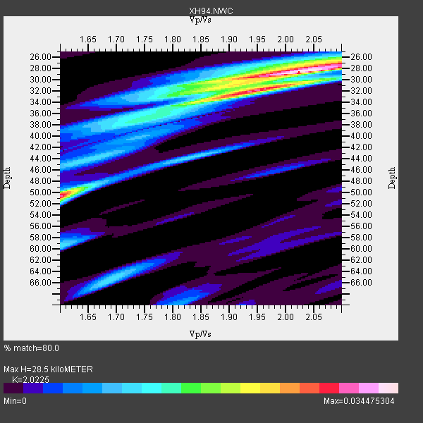
| Thickness Estimate: | 28 km |
| Thickness StdDev: | 12 km |
| Vp/Vs Estimate: | 2.02 |
| Vp/Vs StdDev: | 0.17 |
| Vs Estimate: | 3.063 km/s |
| Poisson's Ratio: | 0.34 |
| Peak Value: | 0.03 |
| Assumed Vp: | 6.194 km/s |
| Ps Weight: | 0.33333334 |
| PpPs Weight: | 0.33333334 |
| PsPs Weight: | 0.33333328 |
| Residual Complexity: | 0.640 |
| Nearby stations H: | +- |
| (2.0 deg) Vp/Vs: | +- |
2 with match > 90% ( 20.0 %) and 3 with match > 80% ( 30.0 %) out of 10.
Download stack as xyz text file.
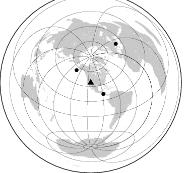
Azimuth Distribution of Events:
Prior Results for this Station
| Study | Thickness | Vp/Vs | Vp | Vs | Poissons Ratio | Extra |
| EARS | 28 km | 2.02 | 6.194 km/s | 3.063 km/s | 0.34 | |
| Crust2.0 | 34 km | 1.78 | 6.194 km/s | 3.483 km/s | 0.27 | MD,thin extended crust, 1.5 km seds. |
| Global Maxima | 28 km | 2.02 | 6.194 km/s | 3.063 km/s | 0.34 | amp=0.034475304 |
| Local Maxima 1 | 50 km | 1.60 | 6.194 km/s | 3.871 km/s | 0.18 | amp=0.02809495 |
| Local Maxima 2 | 32 km | 1.93 | 6.194 km/s | 3.201 km/s | 0.32 | amp=0.0181086 |
| Local Maxima 3 | 32 km | 1.86 | 6.194 km/s | 3.339 km/s | 0.30 | amp=0.013327198 |
| Local Maxima 4 | 66 km | 1.69 | 6.194 km/s | 3.676 km/s | 0.23 | amp=0.011691152 |
| Predicted Arrivals for vertical incidence (zero ray parameter) | |
| Ps | 4.70 SECOND |
| PpPs | 13.91 SECOND |
| PsPs/PpSs | 18.61 SECOND |
Events Processed for this Station
Download zip of receiver functions as SAC
Plot maxima for each earthquake.
Events Used in the Stack
(3 events)| Radial Match | Distance | Baz | FERegion | Time | Lat/Lon | Depth | Magnitude |
| 92.41386 | 37.6 deg | 311.62 deg | Unimak Island Region, Alaska | 1995/07/08 17:15:28 GMT | (53.6, -163.5) | 33 km | 5.8 MB, 5.7 MS, 5.5 UNKNOWN, 6.0 MW |
| 91.46778 | 33.9 deg | 131.708 deg | Off Coast Of Central America | 1995/06/14 11:11:49 GMT | (12.2, -88.3) | 39 km | 5.6 MB, 6.0 MS, 6.6 UNKNOWN |
| 83.02118 | 92.4 deg | 32.699 deg | Greece | 1995/05/13 08:47:12 GMT | (40.1, 21.7) | 13 km | 6.2 MB, 6.5 MS, 6.6 UNKNOWN, 6.5 MD |
Losers
(7 events)| Radial Match | Distance | Baz | FERegion | Time | Lat/Lon | Depth | Magnitude | Reason |
| 84.0101 | 93.7 deg | 243.765 deg | Southeast Of Loyalty Islands | 1995/05/16 20:31:14 GMT | (-23.1, 170.1) | 33 km | 5.8 MB | |
| 82.24151 | 82.6 deg | 147.948 deg | Near Coast Of Central Chile | 1995/03/22 20:05:55 GMT | (-36.3, -72.9) | 40 km | 5.2 MB, 5.5 MS | |
| 78.908134 | 33.5 deg | 115.136 deg | Caribbean Sea | 1995/06/27 10:09:58 GMT | (18.8, -81.7) | 10 km | 5.7 MB, 5.6 MS, 6.2 UNKNOWN, 6.1 MW | |
| 75.64352 | 44.8 deg | 137.189 deg | Off Coast Of Ecuador | 1995/04/27 12:44:38 GMT | (1.2, -84.9) | 10 km | 5.3 MB, 6.0 MS, 6.2 UNKNOWN, 6.2 MW | |
| 70.98538 | 94.1 deg | 33.292 deg | Greece | 1995/06/15 00:15:48 GMT | (38.4, 22.3) | 14 km | 6.0 MB, 6.5 MS, 6.5 UNKNOWN, 5.7 ML | |
| 68.87033 | 51.7 deg | 98.655 deg | Leeward Islands | 1995/03/08 03:45:59 GMT | (16.6, -59.6) | 15 km | 6.3 MB, 6.2 MS, 6.4 UNKNOWN, 6.1 MD | |
| 65.9746 | 59.5 deg | 69.054 deg | Northern Mid-Atlantic Ridge | 1995/04/17 07:14:35 GMT | (33.8, -38.6) | 10 km | 5.8 MB, 5.8 MS, 5.9 UNKNOWN, 6.1 MW |
