
Station XH PHR - Pahroc, Nevada
Network: XH94 - Colorado Plateau-Great Basin Network
Nearby stations (2 deg radius)
| Station | Name | (Lat, Lon) | Start / End | Elevation |
| PHR | Pahroc, Nevada | (37.65, -114.99) | 1994-10-18 / 1995-03-13 | 1585 m |
| Crust2 Type: | M5,extended crust, 0.5 km seds. |
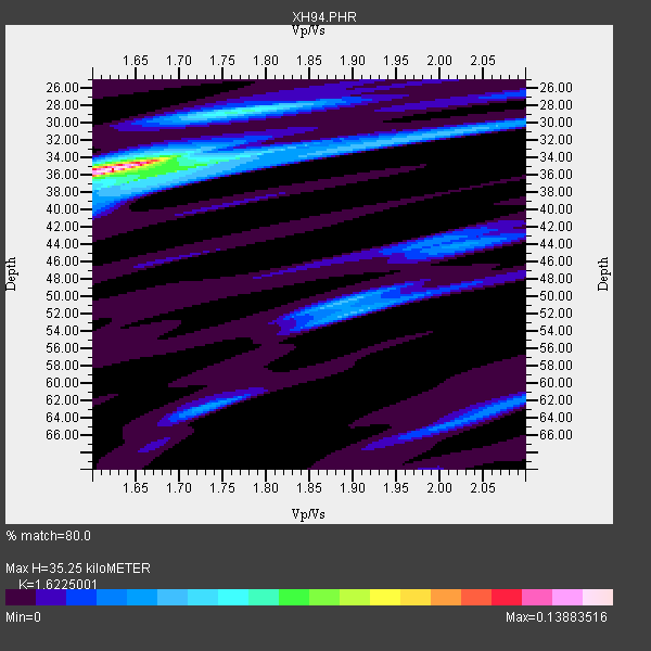
| Thickness Estimate: | 35 km |
| Thickness StdDev: | 2.6 km |
| Vp/Vs Estimate: | 1.62 |
| Vp/Vs StdDev: | 0.05 |
| Vs Estimate: | 3.868 km/s |
| Poisson's Ratio: | 0.19 |
| Peak Value: | 0.14 |
| Assumed Vp: | 6.276 km/s |
| Ps Weight: | 0.33333334 |
| PpPs Weight: | 0.33333334 |
| PsPs Weight: | 0.33333328 |
| Residual Complexity: | 0.552 |
| Nearby stations H: | +- |
| (2.0 deg) Vp/Vs: | +- |
1 with match > 90% ( 7.6923075 %) and 3 with match > 80% ( 23.076923 %) out of 13.
Download stack as xyz text file.
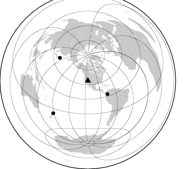
Azimuth Distribution of Events:
Prior Results for this Station
| Study | Thickness | Vp/Vs | Vp | Vs | Poissons Ratio | Extra |
| EARS | 35 km | 1.62 | 6.276 km/s | 3.868 km/s | 0.19 | |
| Crust2.0 | 31 km | 1.78 | 6.276 km/s | 3.529 km/s | 0.27 | M5,extended crust, 0.5 km seds. |
| Global Maxima | 35 km | 1.62 | 6.276 km/s | 3.868 km/s | 0.19 | amp=0.13883516 |
| Local Maxima 1 | 28 km | 1.78 | 6.276 km/s | 3.526 km/s | 0.27 | amp=0.054425385 |
| Local Maxima 2 | 36 km | 1.70 | 6.276 km/s | 3.703 km/s | 0.23 | amp=0.048813097 |
| Local Maxima 3 | 50 km | 1.89 | 6.276 km/s | 3.321 km/s | 0.31 | amp=0.03966664 |
| Local Maxima 4 | 52 km | 1.90 | 6.276 km/s | 3.303 km/s | 0.31 | amp=0.028270334 |
| Predicted Arrivals for vertical incidence (zero ray parameter) | |
| Ps | 3.50 SECOND |
| PpPs | 14.73 SECOND |
| PsPs/PpSs | 18.23 SECOND |
Events Processed for this Station
Download zip of receiver functions as SAC
Plot maxima for each earthquake.
Events Used in the Stack
(3 events)| Radial Match | Distance | Baz | FERegion | Time | Lat/Lon | Depth | Magnitude |
| 93.74501 | 74.2 deg | 309.008 deg | Off East Coast Of Honshu, Japan | 1994/12/28 12:19:23 GMT | (40.5, 143.5) | 33 km | 6.4 MB, 7.5 MS, 7.2 UNKNOWN, 7.7 MW |
| 87.754036 | 96.7 deg | 226.959 deg | Off E. Coast Of N. Island, N.Z. | 1995/02/05 22:51:10 GMT | (-37.7, 178.8) | 59 km | 6.4 MB, 7.1 UNKNOWN, 7.1 MW |
| 82.97031 | 48.3 deg | 124.076 deg | Colombia | 1995/02/08 18:40:25 GMT | (4.2, -76.6) | 69 km | 6.3 MB, 6.4 UNKNOWN, 6.0 MD |
Losers
(10 events)| Radial Match | Distance | Baz | FERegion | Time | Lat/Lon | Depth | Magnitude | Reason |
| 77.04273 | 88.2 deg | 235.269 deg | South Of Fiji Islands | 1994/10/27 22:20:31 GMT | (-25.8, 179.3) | 549 km | 5.9 MB, 6.8 UNKNOWN, 6.7 MW | |
| 75.29264 | 66.3 deg | 134.746 deg | Southern Peru | 1994/11/11 08:48:30 GMT | (-15.6, -72.6) | 121 km | 5.6 MB, 6.2 UNKNOWN, 5.9 MW | |
| 73.607185 | 74.1 deg | 308.97 deg | Off East Coast Of Honshu, Japan | 1994/12/28 12:29:21 GMT | (40.5, 143.6) | 33 km | 5.6 MB | |
| 73.02505 | 62.1 deg | 129.505 deg | Peru-Brazil Border Region | 1994/11/04 01:13:20 GMT | (-9.3, -71.3) | 598 km | 5.8 MB, 5.9 UNKNOWN, 6.2 MW | |
| 62.10886 | 62.0 deg | 129.5 deg | Peru-Brazil Border Region | 1994/11/05 12:05:28 GMT | (-9.3, -71.3) | 597 km | 5.6 MB, 5.8 UNKNOWN, 5.6 MW | |
| 59.93567 | 86.2 deg | 231.859 deg | South Of Fiji Islands | 1995/01/23 10:16:18 GMT | (-26.8, -176.4) | 33 km | 5.3 MB, 5.7 MS, 6.0 UNKNOWN, 5.8 MW | |
| 56.3879 | 42.4 deg | 128.113 deg | South Of Panama | 1995/02/05 20:37:10 GMT | (6.8, -82.7) | 10 km | 5.8 MB, 5.4 MS, 6.1 UNKNOWN, 5.3 MD | |
| 55.93611 | 74.0 deg | 309.119 deg | Off East Coast Of Honshu, Japan | 1995/01/01 06:59:54 GMT | (40.6, 143.6) | 10 km | 5.7 MB, 6.2 MS, 5.9 UNKNOWN, 6.4 MW | |
| 54.056015 | 71.9 deg | 134.108 deg | Chile-Bolivia Border Region | 1995/02/10 20:27:03 GMT | (-19.8, -68.5) | 164 km | 5.7 UNKNOWN, 5.4 MB, 5.7 MW | |
| 50.94538 | 87.9 deg | 254.59 deg | Santa Cruz Islands | 1994/11/03 03:07:22 GMT | (-10.9, 166.2) | 165 km | 5.6 UNKNOWN, 5.3 MB |
