
Station XH LCOL - Laguna Colorado
Network: XH96 - Bolivian Experiment
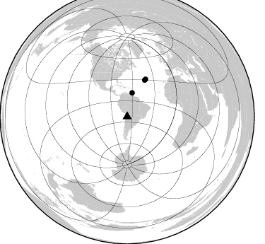
Nearby stations (2 deg radius)

| Station | Name | (Lat, Lon) | Start / End | Elevation |
| LCOL | Laguna Colorado | (-22.28, -67.65) | 1996-11-05 / 1997-12-31 | 4630 m |
| Crust2 Type: | R2,orogen/65km Bolivia, 0.5 km seds. |
| Thickness Estimate: | 30 km |
| Thickness StdDev: | 6.7 km |
| Vp/Vs Estimate: | 1.74 |
| Vp/Vs StdDev: | 0.03 |
| Vs Estimate: | 3.719 km/s |
| Poisson's Ratio: | 0.25 |
| Peak Value: | 0.24 |
| Assumed Vp: | 6.481 km/s |
| Ps Weight: | 0.33333334 |
| PpPs Weight: | 0.33333334 |
| PsPs Weight: | 0.33333328 |
| Residual Complexity: | 0.539 |
| Nearby stations H: | +- |
| (2.0 deg) Vp/Vs: | +- |
1 with match > 90% ( 9.090909 %) and 3 with match > 80% ( 27.272728 %) out of 11.
Download stack as xyz text file.
Azimuth Distribution of Events:
Prior Results for this Station
| Study | Thickness | Vp/Vs | Vp | Vs | Poissons Ratio | Extra |
| EARS | 30 km | 1.74 | 6.481 km/s | 3.719 km/s | 0.25 | |
| Crust2.0 | 65 km | 1.76 | 6.481 km/s | 3.685 km/s | 0.26 | R2,orogen/65km Bolivia, 0.5 km seds. |
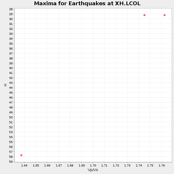
| Global Maxima | 30 km | 1.74 | 6.481 km/s | 3.719 km/s | 0.25 | amp=0.2367495 |
| Local Maxima 1 | 59 km | 1.62 | 6.481 km/s | 4.007 km/s | 0.19 | amp=0.10887596 |
| Local Maxima 2 | 54 km | 1.69 | 6.481 km/s | 3.846 km/s | 0.23 | amp=0.097231776 |
| Local Maxima 3 | 58 km | 1.60 | 6.481 km/s | 4.05 km/s | 0.18 | amp=0.0661 |
| Local Maxima 4 | 28 km | 1.82 | 6.481 km/s | 3.566 km/s | 0.28 | amp=0.058027007 |
| Predicted Arrivals for vertical incidence (zero ray parameter) | |
| Ps | 3.38 SECOND |
| PpPs | 12.48 SECOND |
| PsPs/PpSs | 15.86 SECOND |
Events Processed for this Station
Download zip of receiver functions as SAC
Plot maxima for each earthquake.
Events Used in the Stack
(3 events)| Radial Match | Distance | Baz | FERegion | Time | Lat/Lon | Depth | Magnitude |
| 94.63747 | 57.1 deg | 25.731 deg | Northern Mid-Atlantic Ridge | 1996/12/09 11:28:48 GMT | (29.9, -42.9) | 10 km | 5.9 MB, 6.1 MS, 6.0 UNKNOWN, 5.9 MW |
| 87.71493 | 58.6 deg | 26.286 deg | Northern Mid-Atlantic Ridge | 1997/03/23 20:48:48 GMT | (31.0, -41.5) | 10 km | 5.9 MS, 5.4 MB, 5.9 UNKNOWN, 5.9 MW |
| 86.084114 | 34.1 deg | 11.78 deg | Windward Islands | 1997/04/02 06:14:31 GMT | (11.4, -60.9) | 45 km | 5.8 MB, 5.5 MS, 6.2 UNKNOWN, 5.6 MD |
Losers
(8 events)| Radial Match | Distance | Baz | FERegion | Time | Lat/Lon | Depth | Magnitude | Reason |
| 95.85455 | 48.7 deg | 319.442 deg | Near Coast Of Guerrero, Mexico | 1997/07/19 14:22:08 GMT | (16.3, -98.2) | 33 km | 5.7 MB, 6.3 MS, 6.8 UNKNOWN, 6.0 ME | |
| 92.621635 | 56.5 deg | 313.525 deg | Off Coast Of Jalisco, Mexico | 1997/05/01 11:37:36 GMT | (19.0, -107.3) | 33 km | 6.1 MB, 6.8 MS, 7.1 UNKNOWN, 7.1 ME | |
| 89.5126 | 52.5 deg | 318.16 deg | Guerrero, Mexico | 1997/05/22 07:50:53 GMT | (18.7, -101.6) | 70 km | 5.9 MB, 6.0 MS, 6.6 UNKNOWN, 6.5 MW | |
| 74.97636 | 43.3 deg | 62.879 deg | Central Mid-Atlantic Ridge | 1996/12/10 08:36:18 GMT | (0.9, -30.0) | 10 km | 6.0 MB, 6.2 MS, 6.6 UNKNOWN, 6.6 MW | |
| 74.60437 | 33.2 deg | 332.549 deg | South Of Panama | 1997/04/01 15:11:49 GMT | (7.8, -82.4) | 33 km | 5.7 MB, 5.4 MS, 6.1 UNKNOWN, 5.3 MD | |
| 69.19853 | 46.7 deg | 150.363 deg | South Sandwich Islands Region | 1997/06/02 21:24:38 GMT | (-57.8, -25.5) | 33 km | 5.9 MB, 5.8 MS, 6.1 UNKNOWN, 6.1 MW | |
| 62.53559 | 49.9 deg | 133.903 deg | Southern Mid-Atlantic Ridge | 1997/01/17 23:24:09 GMT | (-47.4, -13.5) | 10 km | 5.7 MS, 5.4 MB, 5.8 UNKNOWN, 5.6 MW | |
| 49.32942 | 97.2 deg | 242.385 deg | Tonga Islands Region | 1997/03/07 03:04:00 GMT | (-22.4, -175.9) | 33 km | 5.7 MS, 5.1 MB, 6.0 UNKNOWN, 5.8 MW |
