
Station XH OLLA - Ollague
Network: XH96 - Bolivian Experiment
Nearby stations (2 deg radius)
| Station | Name | (Lat, Lon) | Start / End | Elevation |
| OLLA | Ollague | (-21.32, -68.04) | 1996-10-30 / 1997-12-31 | 4180 m |
| Crust2 Type: | R3,orogen/70km Chile, 1 km seds. |
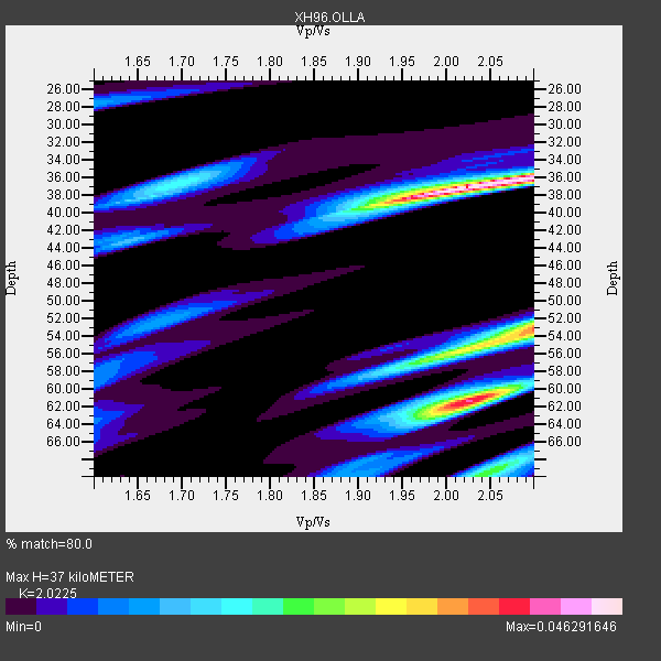
| Thickness Estimate: | 37 km |
| Thickness StdDev: | 11 km |
| Vp/Vs Estimate: | 2.02 |
| Vp/Vs StdDev: | 0.11 |
| Vs Estimate: | 3.201 km/s |
| Poisson's Ratio: | 0.34 |
| Peak Value: | 0.05 |
| Assumed Vp: | 6.475 km/s |
| Ps Weight: | 0.33333334 |
| PpPs Weight: | 0.33333334 |
| PsPs Weight: | 0.33333328 |
| Residual Complexity: | 0.760 |
| Nearby stations H: | +- |
| (2.0 deg) Vp/Vs: | +- |
2 with match > 90% ( 20.0 %) and 5 with match > 80% ( 50.0 %) out of 10.
Download stack as xyz text file.
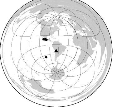
Azimuth Distribution of Events:
Prior Results for this Station
| Study | Thickness | Vp/Vs | Vp | Vs | Poissons Ratio | Extra |
| EARS | 37 km | 2.02 | 6.475 km/s | 3.201 km/s | 0.34 | |
| Crust2.0 | 70 km | 1.76 | 6.475 km/s | 3.679 km/s | 0.26 | R3,orogen/70km Chile, 1 km seds. |
| Global Maxima | 37 km | 2.02 | 6.475 km/s | 3.201 km/s | 0.34 | amp=0.046291646 |
| Local Maxima 1 | 61 km | 2.03 | 6.475 km/s | 3.198 km/s | 0.34 | amp=0.039682124 |
| Local Maxima 2 | 53 km | 2.10 | 6.475 km/s | 3.087 km/s | 0.35 | amp=0.034988012 |
| Local Maxima 3 | 69 km | 2.05 | 6.475 km/s | 3.159 km/s | 0.34 | amp=0.022646703 |
| Local Maxima 4 | 56 km | 2.00 | 6.475 km/s | 3.233 km/s | 0.33 | amp=0.021135632 |
| Predicted Arrivals for vertical incidence (zero ray parameter) | |
| Ps | 5.84 SECOND |
| PpPs | 17.27 SECOND |
| PsPs/PpSs | 23.11 SECOND |
Events Processed for this Station
Download zip of receiver functions as SAC
Plot maxima for each earthquake.
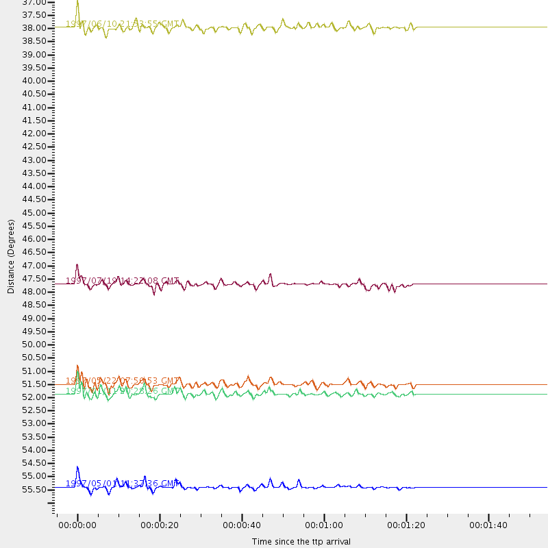
Events Used in the Stack
(5 events)| Radial Match | Distance | Baz | FERegion | Time | Lat/Lon | Depth | Magnitude |
| 92.08829 | 47.7 deg | 319.275 deg | Near Coast Of Guerrero, Mexico | 1997/07/19 14:22:08 GMT | (16.3, -98.2) | 33 km | 5.7 MB, 6.3 MS, 6.8 UNKNOWN, 6.0 ME |
| 90.65941 | 55.5 deg | 313.369 deg | Off Coast Of Jalisco, Mexico | 1997/05/01 11:37:36 GMT | (19.0, -107.3) | 33 km | 6.1 MB, 6.8 MS, 7.1 UNKNOWN, 7.1 ME |
| 89.41961 | 52.0 deg | 316.587 deg | Michoacan, Mexico | 1997/01/11 20:28:26 GMT | (18.2, -102.8) | 33 km | 6.5 MB, 6.9 MS, 7.1 UNKNOWN, 7.0 ME |
| 86.83683 | 51.6 deg | 318.017 deg | Guerrero, Mexico | 1997/05/22 07:50:53 GMT | (18.7, -101.6) | 70 km | 5.9 MB, 6.0 MS, 6.6 UNKNOWN, 6.5 MW |
| 83.93447 | 37.8 deg | 238.686 deg | Southern East Pacific Rise | 1997/06/10 21:53:55 GMT | (-35.8, -108.1) | 10 km | 5.8 MB, 6.1 MS, 6.5 UNKNOWN, 5.8 MS |
Losers
(5 events)| Radial Match | Distance | Baz | FERegion | Time | Lat/Lon | Depth | Magnitude | Reason |
| 82.875984 | 97.3 deg | 242.659 deg | Tonga Islands Region | 1997/03/07 03:04:00 GMT | (-22.4, -175.9) | 33 km | 5.7 MS, 5.1 MB, 6.0 UNKNOWN, 5.8 MW | |
| 76.31872 | 33.3 deg | 12.76 deg | Windward Islands | 1997/04/02 06:14:31 GMT | (11.4, -60.9) | 45 km | 5.8 MB, 5.5 MS, 6.2 UNKNOWN, 5.6 MD | |
| 67.05128 | 43.2 deg | 64.105 deg | Central Mid-Atlantic Ridge | 1996/12/10 08:36:18 GMT | (0.9, -30.0) | 10 km | 6.0 MB, 6.2 MS, 6.6 UNKNOWN, 6.6 MW | |
| 59.23575 | 96.8 deg | 232.983 deg | Kermadec Islands Region | 1997/03/21 12:07:17 GMT | (-31.2, 179.6) | 449 km | 5.6 MB, 6.3 UNKNOWN, 6.2 MW | |
| 55.529114 | 47.7 deg | 150.651 deg | South Sandwich Islands Region | 1997/06/02 21:24:38 GMT | (-57.8, -25.5) | 33 km | 5.9 MB, 5.8 MS, 6.1 UNKNOWN, 6.1 MW |
