
Station XH UYUN - Uyuni
Network: XH96 - Bolivian Experiment
Nearby stations (2 deg radius)
| Station | Name | (Lat, Lon) | Start / End | Elevation |
| UYUN | Uyuni | (-20.46, -66.75) | 1996-10-27 / 1997-12-31 | 3870 m |
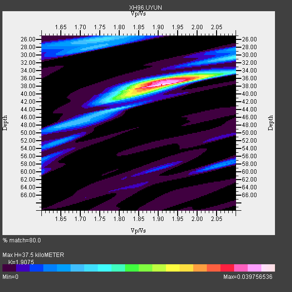
| Crust2 Type: | RC,orogen/65km Tibet, 4.5 km seds. |
| Thickness Estimate: | 38 km |
| Thickness StdDev: | 5.8 km |
| Vp/Vs Estimate: | 1.91 |
| Vp/Vs StdDev: | 0.07 |
| Vs Estimate: | 3.313 km/s |
| Poisson's Ratio: | 0.31 |
| Peak Value: | 0.04 |
| Assumed Vp: | 6.319 km/s |
| Ps Weight: | 0.33333334 |
| PpPs Weight: | 0.33333334 |
| PsPs Weight: | 0.33333328 |
| Residual Complexity: | 0.507 |
| Nearby stations H: | +- |
| (2.0 deg) Vp/Vs: | +- |
0 with match > 90% ( 0.0 %) and 4 with match > 80% ( 50.0 %) out of 8.
Download stack as xyz text file.
Azimuth Distribution of Events:

Prior Results for this Station
| Study | Thickness | Vp/Vs | Vp | Vs | Poissons Ratio | Extra |
| EARS | 38 km | 1.91 | 6.319 km/s | 3.313 km/s | 0.31 | |
| Crust2.0 | 65 km | 1.76 | 6.319 km/s | 3.593 km/s | 0.26 | RC,orogen/65km Tibet, 4.5 km seds. |
| Global Maxima | 38 km | 1.91 | 6.319 km/s | 3.313 km/s | 0.31 | amp=0.039756536 |
| Local Maxima 1 | 36 km | 1.92 | 6.319 km/s | 3.296 km/s | 0.31 | amp=0.020939019 |
| Local Maxima 2 | 40 km | 1.81 | 6.319 km/s | 3.491 km/s | 0.28 | amp=0.013193515 |
| Local Maxima 3 | 26 km | 1.75 | 6.319 km/s | 3.621 km/s | 0.26 | amp=0.012674227 |
| Local Maxima 4 | 58 km | 2.06 | 6.319 km/s | 3.071 km/s | 0.35 | amp=0.008931377 |
| Predicted Arrivals for vertical incidence (zero ray parameter) | |
| Ps | 5.39 SECOND |
| PpPs | 17.25 SECOND |
| PsPs/PpSs | 22.64 SECOND |
Events Processed for this Station
Download zip of receiver functions as SAC
Plot maxima for each earthquake.
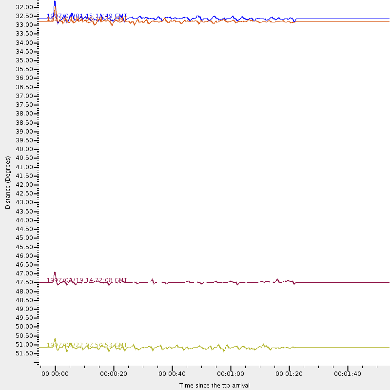
Events Used in the Stack
(4 events)| Radial Match | Distance | Baz | FERegion | Time | Lat/Lon | Depth | Magnitude |
| 84.916985 | 47.9 deg | 317.484 deg | Near Coast Of Guerrero, Mexico | 1997/07/19 14:22:08 GMT | (16.3, -98.2) | 33 km | 5.7 MB, 6.3 MS, 6.8 UNKNOWN, 6.0 ME |
| 83.554 | 51.8 deg | 316.401 deg | Guerrero, Mexico | 1997/05/22 07:50:53 GMT | (18.7, -101.6) | 70 km | 5.9 MB, 6.0 MS, 6.6 UNKNOWN, 6.5 MW |
| 81.91978 | 32.2 deg | 10.736 deg | Windward Islands | 1997/04/02 06:14:31 GMT | (11.4, -60.9) | 45 km | 5.8 MB, 5.5 MS, 6.2 UNKNOWN, 5.6 MD |
| 81.59637 | 32.0 deg | 329.705 deg | South Of Panama | 1997/04/01 15:11:49 GMT | (7.8, -82.4) | 33 km | 5.7 MB, 5.4 MS, 6.1 UNKNOWN, 5.3 MD |
Losers
(4 events)| Radial Match | Distance | Baz | FERegion | Time | Lat/Lon | Depth | Magnitude | Reason |
| 81.51951 | 52.2 deg | 314.991 deg | Michoacan, Mexico | 1997/01/11 20:28:26 GMT | (18.2, -102.8) | 33 km | 6.5 MB, 6.9 MS, 7.1 UNKNOWN, 7.0 ME | |
| 77.6514 | 96.6 deg | 231.876 deg | South Of Kermadec Islands | 1996/11/11 00:47:21 GMT | (-32.5, -179.0) | 33 km | 5.9 MB, 5.9 MS, 6.1 UNKNOWN, 6.0 MW | |
| 63.239925 | 47.9 deg | 151.527 deg | South Sandwich Islands Region | 1997/06/02 21:24:38 GMT | (-57.8, -25.5) | 33 km | 5.9 MB, 5.8 MS, 6.1 UNKNOWN, 6.1 MW | |
| 61.68689 | 41.7 deg | 63.91 deg | Central Mid-Atlantic Ridge | 1996/12/10 08:36:18 GMT | (0.9, -30.0) | 10 km | 6.0 MB, 6.2 MS, 6.6 UNKNOWN, 6.6 MW |
