
Station XI AAUS - Addis Ababa University
Network: XI00 - Ethiopia/Kenya Broadband Seismic Experiment
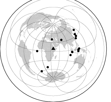
Nearby stations (2 deg radius)
| Station | Name | (Lat, Lon) | Start / End | Elevation |
| AAUS | Addis Ababa University | (9.03, 38.77) | 2000-01-21 / 2002-12-31 | 2245 m |
| Crust2 Type: | G9,thin custal Archean 0.1 km seds., South American |
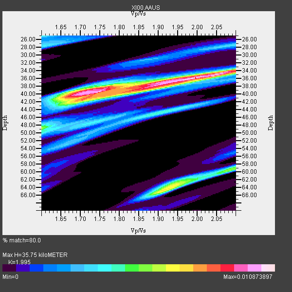
| Thickness Estimate: | 36 km |
| Thickness StdDev: | 10 km |
| Vp/Vs Estimate: | 2.00 |
| Vp/Vs StdDev: | 0.15 |
| Vs Estimate: | 3.24 km/s |
| Poisson's Ratio: | 0.33 |
| Peak Value: | 0.01 |
| Assumed Vp: | 6.464 km/s |
| Ps Weight: | 0.33333334 |
| PpPs Weight: | 0.33333334 |
| PsPs Weight: | 0.33333328 |
| Residual Complexity: | 0.746 |
| Nearby stations H: | +- |
| (2.0 deg) Vp/Vs: | +- |
4 with match > 90% ( 25.0 %) and 16 with match > 80% ( 100.0 %) out of 16.
Download stack as xyz text file.
Azimuth Distribution of Events:
Prior Results for this Station
| Study | Thickness | Vp/Vs | Vp | Vs | Poissons Ratio | Extra |
| EARS | 36 km | 2.00 | 6.464 km/s | 3.24 km/s | 0.33 | |
| Crust2.0 | 31 km | 1.76 | 6.464 km/s | 3.663 km/s | 0.26 | G9,thin custal Archean 0.1 km seds., South American |
| Global Maxima | 36 km | 2.00 | 6.464 km/s | 3.24 km/s | 0.33 | amp=0.010873897 |
| Local Maxima 1 | 40 km | 1.74 | 6.464 km/s | 3.709 km/s | 0.25 | amp=0.008646095 |
| Local Maxima 2 | 64 km | 1.92 | 6.464 km/s | 3.371 km/s | 0.31 | amp=0.007289747 |
| Local Maxima 3 | 59 km | 2.10 | 6.464 km/s | 3.082 km/s | 0.35 | amp=0.0056599397 |
| Local Maxima 4 | 39 km | 1.84 | 6.464 km/s | 3.513 km/s | 0.29 | amp=0.005551357 |
| Predicted Arrivals for vertical incidence (zero ray parameter) | |
| Ps | 5.50 SECOND |
| PpPs | 16.57 SECOND |
| PsPs/PpSs | 22.07 SECOND |
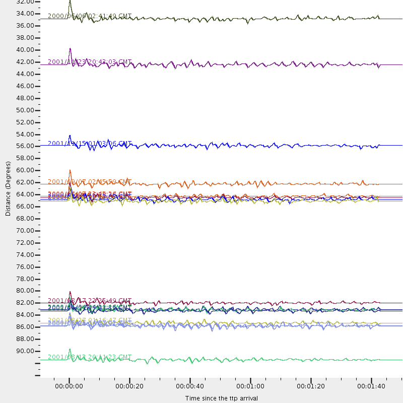
Events Processed for this Station
Download zip of receiver functions as SAC
Plot maxima for each earthquake.
Events Used in the Stack
(16 events)| Radial Match | Distance | Baz | FERegion | Time | Lat/Lon | Depth | Magnitude |
| 96.277115 | 64.6 deg | 99.597 deg | Southern Sumatra, Indonesia | 2000/06/04 16:28:26 GMT | (-4.7, 102.1) | 33 km | 6.8 MB, 8.0 MS, 7.9 MW, 7.7 MW |
| 95.25637 | 64.4 deg | 99.522 deg | Southern Sumatra, Indonesia | 2000/06/07 23:45:26 GMT | (-4.6, 101.9) | 33 km | 6.1 MB, 6.7 MS, 6.7 MW, 6.5 MW |
| 92.743515 | 85.0 deg | 91.901 deg | Sulawesi, Indonesia | 2000/05/04 04:21:16 GMT | (-1.1, 123.6) | 26 km | 6.7 MB, 7.5 MS, 7.6 MW, 7.5 ME |
| 90.67902 | 85.3 deg | 207.28 deg | South Sandwich Islands Region | 2001/04/13 15:33:53 GMT | (-59.7, -25.6) | 26 km | 5.3 MB, 6.0 MS, 6.2 MW, 6.2 MW |
| 89.69234 | 62.2 deg | 110.031 deg | South Indian Ocean | 2001/09/07 02:45:59 GMT | (-13.2, 97.3) | 10 km | 6.2 MB, 5.8 MS, 6.0 MW, 5.9 MW |
| 88.94429 | 31.9 deg | 351.685 deg | Turkey | 2000/06/06 02:41:49 GMT | (40.7, 33.0) | 10 km | 5.5 MB, 6.1 MS, 6.1 MW, 6.0 MW |
| 88.94091 | 87.5 deg | 89.304 deg | Northern Molucca Sea | 2001/08/27 01:16:47 GMT | (1.1, 126.4) | 33 km | 5.8 MB, 5.9 MS, 6.1 MW, 5.9 MW |
| 88.2974 | 85.1 deg | 95.107 deg | Banda Sea | 2000/05/14 20:08:34 GMT | (-4.3, 123.2) | 33 km | 5.9 MB, 5.9 MS, 6.3 MW, 6.2 MW |
| 86.28739 | 88.1 deg | 55.959 deg | Western Honshu, Japan | 2001/03/24 06:27:53 GMT | (34.1, 132.5) | 50 km | 6.4 MB, 6.5 MS, 6.8 MW, 6.4 ME |
| 85.1772 | 40.3 deg | 42.417 deg | Afghanistan-Tajikistan Bord Reg. | 2001/11/23 20:43:03 GMT | (36.4, 71.5) | 106 km | 5.9 MB, 6.1 MW, 6.0 MW |
| 84.50433 | 65.3 deg | 99.852 deg | Southern Sumatra, Indonesia | 2000/06/06 09:58:06 GMT | (-5.1, 102.7) | 33 km | 5.8 MB, 6.1 MS, 6.2 MW, 6.1 MW |
| 84.4556 | 64.9 deg | 196.73 deg | Southwest Of Africa | 2000/04/18 00:12:05 GMT | (-52.5, 13.5) | 10 km | 5.4 MB, 5.3 MS, 5.8 MW, 5.7 MW |
| 84.04067 | 87.9 deg | 60.698 deg | Southeast Of Ryukyu Islands | 2000/06/06 14:57:02 GMT | (29.4, 131.4) | 33 km | 5.8 MB, 6.0 MS, 6.4 MW, 6.4 MW |
| 83.266396 | 83.8 deg | 64.983 deg | Ryukyu Islands, Japan | 2001/08/17 22:25:49 GMT | (25.7, 126.2) | 33 km | 5.6 MB, 5.6 MS, 5.9 MW, 5.9 MW |
| 83.06258 | 94.2 deg | 47.502 deg | Hokkaido, Japan Region | 2001/08/13 20:11:23 GMT | (41.0, 142.3) | 38 km | 6.0 MB, 6.3 MS, 6.4 MW, 6.3 ME |
| 80.35244 | 55.2 deg | 261.729 deg | North Of Ascension Island | 2001/11/15 01:03:06 GMT | (-1.6, -15.6) | 10 km | 5.5 MB, 6.0 MS, 6.3 MW, 6.3 MW |
Losers
(0 events)| Radial Match | Distance | Baz | FERegion | Time | Lat/Lon | Depth | Magnitude | Reason |
