
Station XI BDAR - Bahir Dar #2
Network: XI00 - Ethiopia/Kenya Broadband Seismic Experiment
Nearby stations (2 deg radius)
| Station | Name | (Lat, Lon) | Start / End | Elevation |
| BDAR | Bahir Dar #2 | (9.67, 39.53) | 2001-05-23 / 2002-12-31 | 2802 m |
| Crust2 Type: | G9,thin custal Archean 0.1 km seds., South American |
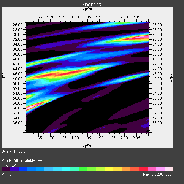
| Thickness Estimate: | 60 km |
| Thickness StdDev: | 11 km |
| Vp/Vs Estimate: | 1.61 |
| Vp/Vs StdDev: | 0.20 |
| Vs Estimate: | 4.015 km/s |
| Poisson's Ratio: | 0.19 |
| Peak Value: | 0.02 |
| Assumed Vp: | 6.464 km/s |
| Ps Weight: | 0.33333334 |
| PpPs Weight: | 0.33333334 |
| PsPs Weight: | 0.33333328 |
| Residual Complexity: | 0.910 |
| Nearby stations H: | 52 km +- 11 km |
| (2.0 deg) Vp/Vs: | 1.71 +- 0.14 |
4 with match > 90% ( 33.333332 %) and 12 with match > 80% ( 100.0 %) out of 12.
Download stack as xyz text file.
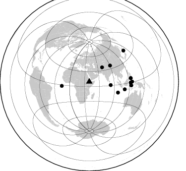
Azimuth Distribution of Events:
Prior Results for this Station
| Study | Thickness | Vp/Vs | Vp | Vs | Poissons Ratio | Extra |
| EARS | 60 km | 1.61 | 6.464 km/s | 4.015 km/s | 0.19 | |
| Crust2.0 | 31 km | 1.76 | 6.464 km/s | 3.663 km/s | 0.26 | G9,thin custal Archean 0.1 km seds., South American |
| Global Maxima | 60 km | 1.61 | 6.464 km/s | 4.015 km/s | 0.19 | amp=0.02001503 |
| Local Maxima 1 | 31 km | 2.07 | 6.464 km/s | 3.119 km/s | 0.35 | amp=0.01843306 |
| Local Maxima 2 | 45 km | 1.79 | 6.464 km/s | 3.616 km/s | 0.27 | amp=0.016214209 |
| Local Maxima 3 | 46 km | 1.68 | 6.464 km/s | 3.859 km/s | 0.22 | amp=0.0127807325 |
| Local Maxima 4 | 42 km | 1.62 | 6.464 km/s | 3.978 km/s | 0.20 | amp=0.011723771 |
| Predicted Arrivals for vertical incidence (zero ray parameter) | |
| Ps | 5.64 SECOND |
| PpPs | 24.13 SECOND |
| PsPs/PpSs | 29.77 SECOND |
Events Processed for this Station
Download zip of receiver functions as SAC
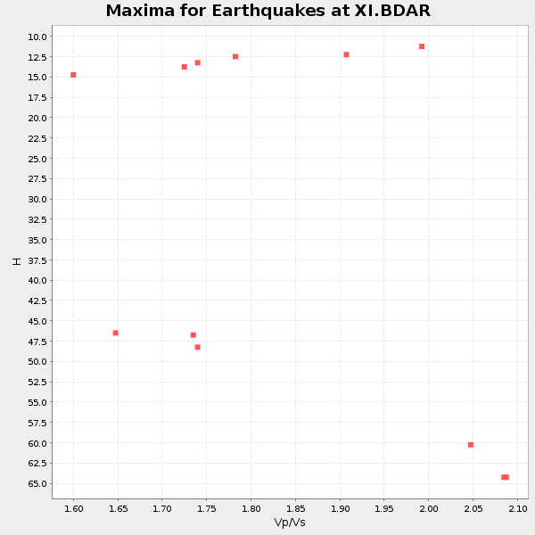
Plot maxima for each earthquake.
Events Used in the Stack
(12 events)| Radial Match | Distance | Baz | FERegion | Time | Lat/Lon | Depth | Magnitude |
| 95.654175 | 85.2 deg | 94.972 deg | Banda Sea | 2001/10/19 03:28:44 GMT | (-4.1, 123.9) | 33 km | 6.3 MB, 7.3 MS, 7.5 MW, 7.4 MW |
| 93.94429 | 83.8 deg | 84.941 deg | Mindanao, Philippines | 2002/03/05 21:16:09 GMT | (6.0, 124.2) | 31 km | 6.3 MB, 7.2 MS, 7.5 MW, 7.2 MW |
| 91.992256 | 53.1 deg | 52.099 deg | Qinghai, China | 2001/11/14 09:26:10 GMT | (35.9, 90.5) | 10 km | 6.1 MB, 8.0 MS, 7.8 MW, 7.7 MW |
| 91.98426 | 61.7 deg | 110.609 deg | South Indian Ocean | 2001/09/07 02:45:59 GMT | (-13.2, 97.3) | 10 km | 6.2 MB, 5.8 MS, 6.0 MW, 5.9 MW |
| 89.90998 | 83.9 deg | 85.097 deg | Mindanao, Philippines | 2002/03/08 18:27:53 GMT | (5.9, 124.3) | 23 km | 5.6 MB, 5.7 MS, 6.0 MW, 5.8 MW |
| 89.8469 | 56.0 deg | 261.497 deg | North Of Ascension Island | 2001/11/15 01:03:06 GMT | (-1.6, -15.6) | 10 km | 5.5 MB, 6.0 MS, 6.3 MW, 6.3 MW |
| 89.73804 | 86.4 deg | 89.769 deg | Northern Molucca Sea | 2001/10/13 16:27:00 GMT | (0.8, 126.0) | 33 km | 5.6 MB, 5.7 MS, 6.0 MW, 5.8 MW |
| 86.521164 | 73.1 deg | 102.059 deg | Java, Indonesia | 2001/10/14 01:10:45 GMT | (-8.6, 110.6) | 67 km | 5.6 MB, 5.3 MS, 5.9 MW, 5.8 MW |
| 84.241684 | 93.2 deg | 47.627 deg | Hokkaido, Japan Region | 2001/08/13 20:11:23 GMT | (41.0, 142.3) | 38 km | 6.0 MB, 6.3 MS, 6.4 MW, 6.3 ME |
| 83.99331 | 83.4 deg | 91.118 deg | Minahassa Peninsula, Sulawesi | 2001/12/09 18:15:02 GMT | (-0.0, 122.9) | 156 km | 5.7 MB, 6.2 MW, 6.0 MW |
| 83.505714 | 43.6 deg | 98.914 deg | North Indian Ocean | 2001/09/02 02:25:54 GMT | (0.9, 82.5) | 10 km | 5.6 MB, 5.8 MS, 6.1 MW, 6.1 MW |
| 81.657135 | 38.7 deg | 41.552 deg | Hindu Kush Region, Afghanistan | 2002/03/03 12:08:07 GMT | (36.4, 70.4) | 209 km | 6.3 MB |
Losers
(0 events)| Radial Match | Distance | Baz | FERegion | Time | Lat/Lon | Depth | Magnitude | Reason |
