
Station XI CHEF - YIRGA CHEFE
Network: XI00 - Ethiopia/Kenya Broadband Seismic Experiment
Nearby stations (2 deg radius)
| Station | Name | (Lat, Lon) | Start / End | Elevation |
| CHEF | YIRGA CHEFE | (6.16, 38.21) | 2001-03-05 / 2002-12-31 | 1701 m |
| Crust2 Type: | G9,thin custal Archean 0.1 km seds., South American |
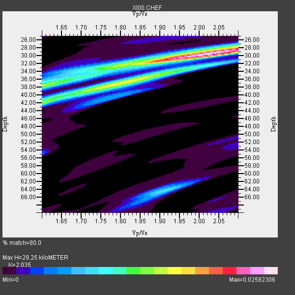
| Thickness Estimate: | 29 km |
| Thickness StdDev: | 2.8 km |
| Vp/Vs Estimate: | 2.04 |
| Vp/Vs StdDev: | 0.12 |
| Vs Estimate: | 3.176 km/s |
| Poisson's Ratio: | 0.34 |
| Peak Value: | 0.03 |
| Assumed Vp: | 6.464 km/s |
| Ps Weight: | 0.33333334 |
| PpPs Weight: | 0.33333334 |
| PsPs Weight: | 0.33333328 |
| Residual Complexity: | 0.605 |
| Nearby stations H: | +- |
| (2.0 deg) Vp/Vs: | +- |
3 with match > 90% ( 33.333332 %) and 9 with match > 80% ( 100.0 %) out of 9.
Download stack as xyz text file.
Azimuth Distribution of Events:

Prior Results for this Station
| Study | Thickness | Vp/Vs | Vp | Vs | Poissons Ratio | Extra |
| EARS | 29 km | 2.04 | 6.464 km/s | 3.176 km/s | 0.34 | |
| Crust2.0 | 31 km | 1.76 | 6.464 km/s | 3.663 km/s | 0.26 | G9,thin custal Archean 0.1 km seds., South American |
| Global Maxima | 29 km | 2.04 | 6.464 km/s | 3.176 km/s | 0.34 | amp=0.02582306 |
| Local Maxima 1 | 42 km | 1.60 | 6.464 km/s | 4.04 km/s | 0.18 | amp=0.0145916585 |
| Local Maxima 2 | 38 km | 1.60 | 6.464 km/s | 4.04 km/s | 0.18 | amp=0.013416826 |
| Local Maxima 3 | 38 km | 1.77 | 6.464 km/s | 3.657 km/s | 0.26 | amp=0.012735238 |
| Local Maxima 4 | 32 km | 1.77 | 6.464 km/s | 3.641 km/s | 0.27 | amp=0.01037992 |
| Predicted Arrivals for vertical incidence (zero ray parameter) | |
| Ps | 4.68 SECOND |
| PpPs | 13.73 SECOND |
| PsPs/PpSs | 18.42 SECOND |
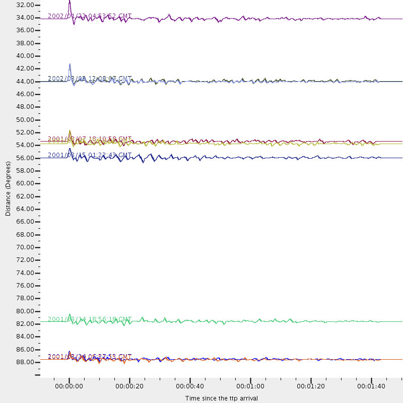
Events Processed for this Station
Download zip of receiver functions as SAC
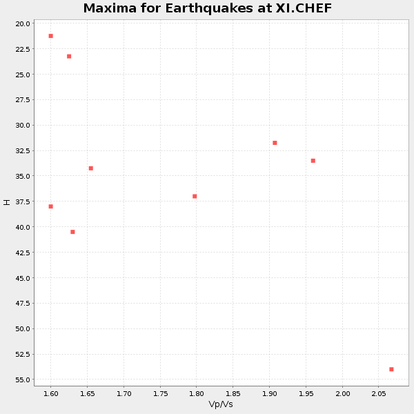
Plot maxima for each earthquake.
Events Used in the Stack
(9 events)| Radial Match | Distance | Baz | FERegion | Time | Lat/Lon | Depth | Magnitude |
| 94.173645 | 31.4 deg | 341.699 deg | Crete, Greece | 2002/01/22 04:53:52 GMT | (35.8, 26.6) | 88 km | 6.2 MB, 6.3 MW, 6.2 MW |
| 91.8769 | 90.2 deg | 55.855 deg | Western Honshu, Japan | 2001/03/24 06:27:53 GMT | (34.1, 132.5) | 50 km | 6.4 MB, 6.5 MS, 6.8 MW, 6.4 ME |
| 91.43234 | 90.2 deg | 94.0 deg | Banda Sea | 2001/03/19 05:52:15 GMT | (-4.0, 128.0) | 33 km | 6.0 MB, 6.5 MS, 6.5 MW, 6.5 MW |
| 89.46032 | 42.2 deg | 39.806 deg | Hindu Kush Region, Afghanistan | 2002/03/03 12:08:19 GMT | (36.5, 70.5) | 226 km | 6.6 MB, 7.4 MW, 7.3 MW |
| 89.4333 | 42.2 deg | 39.859 deg | Hindu Kush Region, Afghanistan | 2002/03/03 12:08:07 GMT | (36.4, 70.4) | 209 km | 6.3 MB |
| 88.00064 | 55.4 deg | 83.76 deg | Nicobar Islands, India Region | 2001/03/15 01:22:43 GMT | (8.7, 94.0) | 33 km | 5.6 MB, 5.9 MS, 6.0 MW, 6.0 MW |
| 85.64272 | 52.9 deg | 51.148 deg | Xizang | 2001/03/05 15:50:06 GMT | (34.4, 86.9) | 33 km | 5.4 MB, 5.8 MS, 5.9 MW, 5.7 MW |
| 85.3126 | 83.7 deg | 90.228 deg | Minahassa Peninsula, Sulawesi | 2001/03/14 18:56:18 GMT | (0.5, 121.9) | 109 km | 5.9 MB, 6.0 MW, 5.9 MW |
| 84.052605 | 52.6 deg | 256.641 deg | Ascension Island Region | 2001/03/07 18:10:58 GMT | (-6.8, -12.9) | 10 km | 5.3 MB, 5.6 MS, 6.0 MW, 6.0 MW |
Losers
(0 events)| Radial Match | Distance | Baz | FERegion | Time | Lat/Lon | Depth | Magnitude | Reason |
