
Station XI DELE - BEDELE
Network: XI00 - Ethiopia/Kenya Broadband Seismic Experiment
Nearby stations (2 deg radius)
| Station | Name | (Lat, Lon) | Start / End | Elevation |
| DELE | BEDELE | (8.44, 36.33) | 2001-03-04 / 2002-12-31 | 1969 m |
| Crust2 Type: | GH,thin Archean 0.5 km seds. |
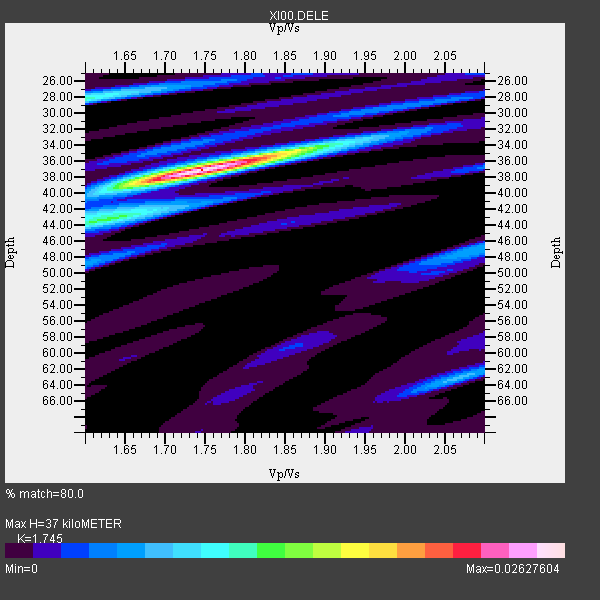
| Thickness Estimate: | 37 km |
| Thickness StdDev: | 4.6 km |
| Vp/Vs Estimate: | 1.75 |
| Vp/Vs StdDev: | 0.07 |
| Vs Estimate: | 3.67 km/s |
| Poisson's Ratio: | 0.26 |
| Peak Value: | 0.03 |
| Assumed Vp: | 6.404 km/s |
| Ps Weight: | 0.33333334 |
| PpPs Weight: | 0.33333334 |
| PsPs Weight: | 0.33333328 |
| Residual Complexity: | 0.437 |
| Nearby stations H: | +- |
| (2.0 deg) Vp/Vs: | +- |
5 with match > 90% ( 38.46154 %) and 13 with match > 80% ( 100.0 %) out of 13.
Download stack as xyz text file.
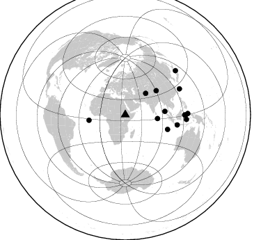
Azimuth Distribution of Events:
Prior Results for this Station
| Study | Thickness | Vp/Vs | Vp | Vs | Poissons Ratio | Extra |
| EARS | 37 km | 1.75 | 6.404 km/s | 3.67 km/s | 0.26 | |
| Crust2.0 | 35 km | 1.76 | 6.404 km/s | 3.629 km/s | 0.26 | GH,thin Archean 0.5 km seds. |
| Global Maxima | 37 km | 1.75 | 6.404 km/s | 3.67 km/s | 0.26 | amp=0.02627604 |
| Local Maxima 1 | 28 km | 1.60 | 6.404 km/s | 4.003 km/s | 0.18 | amp=0.011245831 |
| Local Maxima 2 | 44 km | 1.61 | 6.404 km/s | 3.99 km/s | 0.18 | amp=0.009507353 |
| Local Maxima 3 | 34 km | 1.88 | 6.404 km/s | 3.407 km/s | 0.30 | amp=0.007556734 |
| Local Maxima 4 | 63 km | 2.07 | 6.404 km/s | 3.101 km/s | 0.35 | amp=0.006681974 |
| Predicted Arrivals for vertical incidence (zero ray parameter) | |
| Ps | 4.30 SECOND |
| PpPs | 15.86 SECOND |
| PsPs/PpSs | 20.16 SECOND |
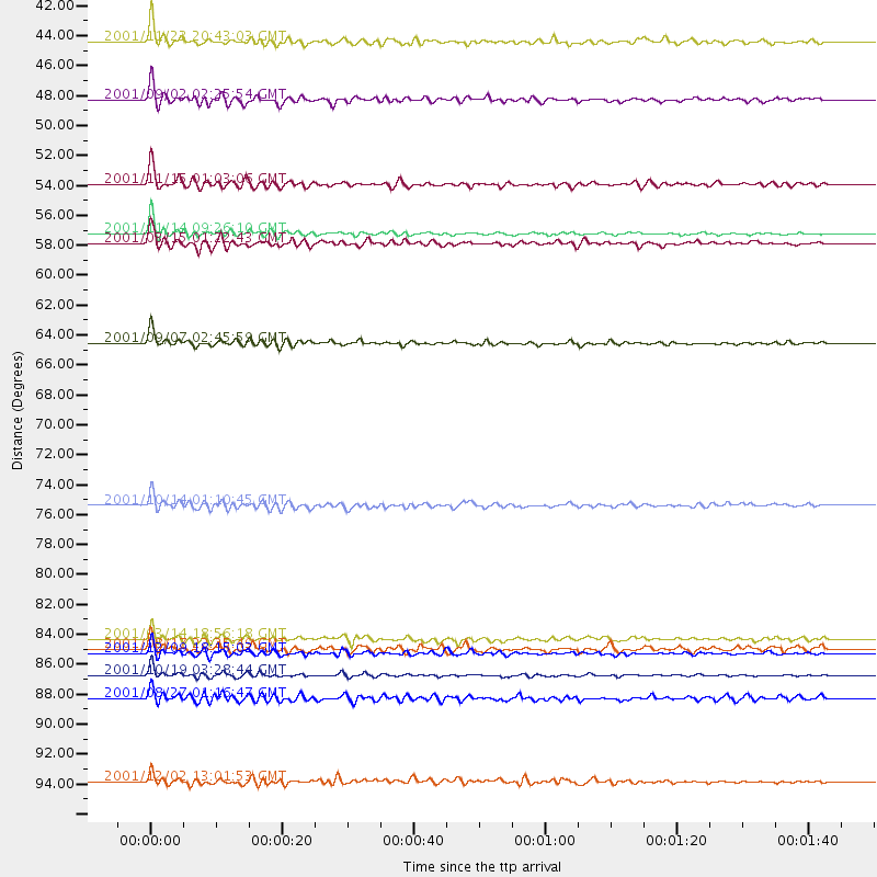
Events Processed for this Station
Download zip of receiver functions as SAC
Plot maxima for each earthquake.
Events Used in the Stack
(13 events)| Radial Match | Distance | Baz | FERegion | Time | Lat/Lon | Depth | Magnitude |
| 96.49173 | 52.7 deg | 261.531 deg | North Of Ascension Island | 2001/11/15 01:03:06 GMT | (-1.6, -15.6) | 10 km | 5.5 MB, 6.0 MS, 6.3 MW, 6.3 MW |
| 95.8115 | 56.3 deg | 52.286 deg | Qinghai, China | 2001/11/14 09:26:10 GMT | (35.9, 90.5) | 10 km | 6.1 MB, 8.0 MS, 7.8 MW, 7.7 MW |
| 94.65934 | 88.2 deg | 94.386 deg | Banda Sea | 2001/10/19 03:28:44 GMT | (-4.1, 123.9) | 33 km | 6.3 MB, 7.3 MS, 7.5 MW, 7.4 MW |
| 93.22213 | 64.2 deg | 108.974 deg | South Indian Ocean | 2001/09/07 02:45:59 GMT | (-13.2, 97.3) | 10 km | 6.2 MB, 5.8 MS, 6.0 MW, 5.9 MW |
| 92.1703 | 57.0 deg | 85.153 deg | Nicobar Islands, India Region | 2001/03/15 01:22:43 GMT | (8.7, 94.0) | 33 km | 5.6 MB, 5.9 MS, 6.0 MW, 6.0 MW |
| 89.66909 | 42.4 deg | 43.595 deg | Afghanistan-Tajikistan Bord Reg. | 2001/11/23 20:43:03 GMT | (36.4, 71.5) | 106 km | 5.9 MB, 6.1 MW, 6.0 MW |
| 88.87196 | 46.6 deg | 96.775 deg | North Indian Ocean | 2001/09/02 02:25:54 GMT | (0.9, 82.5) | 10 km | 5.6 MB, 5.8 MS, 6.1 MW, 6.1 MW |
| 88.20316 | 75.9 deg | 101.051 deg | Java, Indonesia | 2001/10/14 01:10:45 GMT | (-8.6, 110.6) | 67 km | 5.6 MB, 5.3 MS, 5.9 MW, 5.8 MW |
| 84.54924 | 89.9 deg | 88.923 deg | Northern Molucca Sea | 2001/08/27 01:16:47 GMT | (1.1, 126.4) | 33 km | 5.8 MB, 5.9 MS, 6.1 MW, 5.9 MW |
| 83.77677 | 85.5 deg | 90.203 deg | Minahassa Peninsula, Sulawesi | 2001/03/14 18:56:18 GMT | (0.5, 121.9) | 109 km | 5.9 MB, 6.0 MW, 5.9 MW |
| 81.99726 | 95.9 deg | 48.872 deg | Eastern Honshu, Japan | 2001/12/02 13:01:53 GMT | (39.4, 141.1) | 124 km | 6.1 MB, 6.5 MW, 6.5 MW |
| 81.42061 | 86.3 deg | 64.657 deg | Ryukyu Islands, Japan | 2001/08/17 22:25:49 GMT | (25.7, 126.2) | 33 km | 5.6 MB, 5.6 MS, 5.9 MW, 5.9 MW |
| 80.85542 | 86.6 deg | 90.506 deg | Minahassa Peninsula, Sulawesi | 2001/12/09 18:15:02 GMT | (-0.0, 122.9) | 156 km | 5.7 MB, 6.2 MW, 6.0 MW |
Losers
(0 events)| Radial Match | Distance | Baz | FERegion | Time | Lat/Lon | Depth | Magnitude | Reason |
