
Station XI GUDE - GUDER
Network: XI00 - Ethiopia/Kenya Broadband Seismic Experiment
Nearby stations (2 deg radius)
| Station | Name | (Lat, Lon) | Start / End | Elevation |
| GUDE | GUDER | (8.97, 37.77) | 2001-03-13 / 2002-12-31 | 2018 m |
| Crust2 Type: | GH,thin Archean 0.5 km seds. |
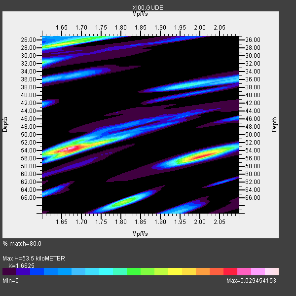
| Thickness Estimate: | 54 km |
| Thickness StdDev: | 12 km |
| Vp/Vs Estimate: | 1.66 |
| Vp/Vs StdDev: | 0.14 |
| Vs Estimate: | 3.852 km/s |
| Poisson's Ratio: | 0.22 |
| Peak Value: | 0.03 |
| Assumed Vp: | 6.404 km/s |
| Ps Weight: | 0.33333334 |
| PpPs Weight: | 0.33333334 |
| PsPs Weight: | 0.33333328 |
| Residual Complexity: | 0.780 |
| Nearby stations H: | +- |
| (2.0 deg) Vp/Vs: | +- |
8 with match > 90% ( 66.666664 %) and 12 with match > 80% ( 100.0 %) out of 12.
Download stack as xyz text file.
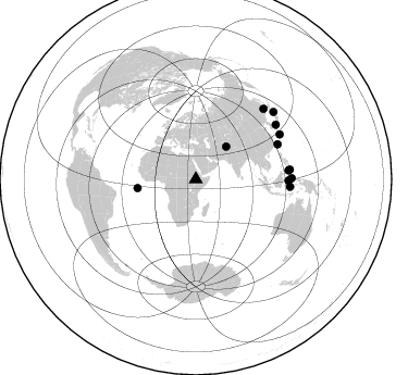
Azimuth Distribution of Events:
Prior Results for this Station
| Study | Thickness | Vp/Vs | Vp | Vs | Poissons Ratio | Extra |
| EARS | 54 km | 1.66 | 6.404 km/s | 3.852 km/s | 0.22 | |
| Crust2.0 | 35 km | 1.76 | 6.404 km/s | 3.629 km/s | 0.26 | GH,thin Archean 0.5 km seds. |
| Global Maxima | 54 km | 1.66 | 6.404 km/s | 3.852 km/s | 0.22 | amp=0.029454153 |
| Local Maxima 1 | 56 km | 2.00 | 6.404 km/s | 3.198 km/s | 0.33 | amp=0.024992753 |
| Local Maxima 2 | 27 km | 1.64 | 6.404 km/s | 3.899 km/s | 0.21 | amp=0.018640984 |
| Local Maxima 3 | 67 km | 1.80 | 6.404 km/s | 3.558 km/s | 0.28 | amp=0.015185102 |
| Local Maxima 4 | 32 km | 1.60 | 6.404 km/s | 4.003 km/s | 0.18 | amp=0.014407047 |
| Predicted Arrivals for vertical incidence (zero ray parameter) | |
| Ps | 5.53 SECOND |
| PpPs | 22.24 SECOND |
| PsPs/PpSs | 27.78 SECOND |
Events Processed for this Station
Download zip of receiver functions as SAC
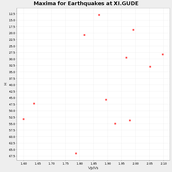
Plot maxima for each earthquake.
Events Used in the Stack
(12 events)| Radial Match | Distance | Baz | FERegion | Time | Lat/Lon | Depth | Magnitude |
| 98.068 | 81.8 deg | 67.022 deg | Taiwan Region | 2001/12/18 04:02:58 GMT | (24.0, 122.7) | 14 km | 6.3 MB, 7.3 MS, 6.9 MW, 6.8 MW |
| 95.5556 | 86.8 deg | 94.63 deg | Banda Sea | 2001/10/19 03:28:44 GMT | (-4.1, 123.9) | 33 km | 6.3 MB, 7.3 MS, 7.5 MW, 7.4 MW |
| 95.09791 | 85.6 deg | 84.608 deg | Mindanao, Philippines | 2002/03/05 21:16:09 GMT | (6.0, 124.2) | 31 km | 6.3 MB, 7.2 MS, 7.5 MW, 7.2 MW |
| 94.36202 | 54.2 deg | 261.518 deg | North Of Ascension Island | 2001/11/15 01:03:06 GMT | (-1.6, -15.6) | 10 km | 5.5 MB, 6.0 MS, 6.3 MW, 6.3 MW |
| 92.013885 | 87.4 deg | 61.966 deg | Ryukyu Islands, Japan | 2001/12/08 20:29:34 GMT | (28.3, 129.6) | 33 km | 5.7 MB, 5.7 MS, 6.2 MW, 6.1 MW |
| 91.941795 | 89.0 deg | 55.817 deg | Western Honshu, Japan | 2001/03/24 06:27:53 GMT | (34.1, 132.5) | 50 km | 6.4 MB, 6.5 MS, 6.8 MW, 6.4 ME |
| 90.944336 | 88.1 deg | 89.453 deg | Northern Molucca Sea | 2001/10/13 16:27:00 GMT | (0.8, 126.0) | 33 km | 5.6 MB, 5.7 MS, 6.0 MW, 5.8 MW |
| 90.15457 | 41.0 deg | 43.053 deg | Afghanistan-Tajikistan Bord Reg. | 2001/11/23 20:43:03 GMT | (36.4, 71.5) | 106 km | 5.9 MB, 6.1 MW, 6.0 MW |
| 89.27038 | 94.5 deg | 49.137 deg | Eastern Honshu, Japan | 2001/12/02 13:01:53 GMT | (39.4, 141.1) | 124 km | 6.1 MB, 6.5 MW, 6.5 MW |
| 85.90809 | 85.2 deg | 90.762 deg | Minahassa Peninsula, Sulawesi | 2001/12/09 18:15:02 GMT | (-0.0, 122.9) | 156 km | 5.7 MB, 6.2 MW, 6.0 MW |
| 81.189926 | 89.9 deg | 44.041 deg | Primor'ye, Russia | 2002/02/01 21:55:20 GMT | (45.5, 136.7) | 356 km | 6.2 MB, 6.0 MW, 5.9 MW |
| 80.236595 | 87.0 deg | 84.134 deg | Mindanao, Philippines | 2002/01/01 11:29:22 GMT | (6.3, 125.7) | 138 km | 5.9 MB, 6.3 MW, 6.3 MW |
Losers
(0 events)| Radial Match | Distance | Baz | FERegion | Time | Lat/Lon | Depth | Magnitude | Reason |
