
Station XI HERO - HIRARO
Network: XI00 - Ethiopia/Kenya Broadband Seismic Experiment
Nearby stations (2 deg radius)
| Station | Name | (Lat, Lon) | Start / End | Elevation |
| HERO | HIRARO | (7.03, 39.28) | 2001-03-02 / 2002-12-31 | 2374 m |
| Crust2 Type: | G9,thin custal Archean 0.1 km seds., South American |
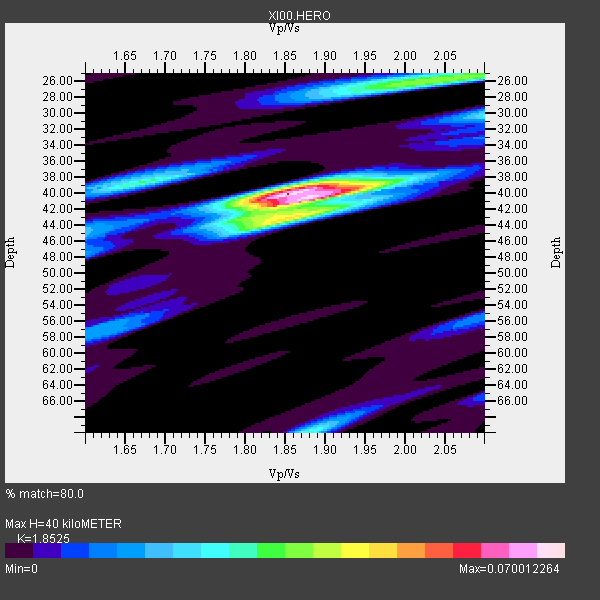
| Thickness Estimate: | 40 km |
| Thickness StdDev: | 1.9 km |
| Vp/Vs Estimate: | 1.85 |
| Vp/Vs StdDev: | 0.03 |
| Vs Estimate: | 3.489 km/s |
| Poisson's Ratio: | 0.29 |
| Peak Value: | 0.07 |
| Assumed Vp: | 6.464 km/s |
| Ps Weight: | 0.33333334 |
| PpPs Weight: | 0.33333334 |
| PsPs Weight: | 0.33333328 |
| Residual Complexity: | 0.639 |
| Nearby stations H: | +- |
| (2.0 deg) Vp/Vs: | +- |
3 with match > 90% ( 50.0 %) and 6 with match > 80% ( 100.0 %) out of 6.
Download stack as xyz text file.
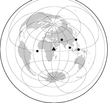
Azimuth Distribution of Events:
Prior Results for this Station
| Study | Thickness | Vp/Vs | Vp | Vs | Poissons Ratio | Extra |
| EARS | 40 km | 1.85 | 6.464 km/s | 3.489 km/s | 0.29 | |
| Crust2.0 | 31 km | 1.76 | 6.464 km/s | 3.663 km/s | 0.26 | G9,thin custal Archean 0.1 km seds., South American |
| Global Maxima | 40 km | 1.85 | 6.464 km/s | 3.489 km/s | 0.29 | amp=0.070012264 |
| Local Maxima 1 | 41 km | 1.88 | 6.464 km/s | 3.447 km/s | 0.30 | amp=0.043500923 |
| Local Maxima 2 | 26 km | 2.04 | 6.464 km/s | 3.168 km/s | 0.34 | amp=0.038501438 |
| Local Maxima 3 | 43 km | 1.87 | 6.464 km/s | 3.456 km/s | 0.30 | amp=0.033646114 |
| Local Maxima 4 | 38 km | 1.67 | 6.464 km/s | 3.87 km/s | 0.22 | amp=0.031503584 |
| Predicted Arrivals for vertical incidence (zero ray parameter) | |
| Ps | 5.28 SECOND |
| PpPs | 17.65 SECOND |
| PsPs/PpSs | 22.93 SECOND |
Events Processed for this Station
Download zip of receiver functions as SAC
Plot maxima for each earthquake.
Events Used in the Stack
(6 events)| Radial Match | Distance | Baz | FERegion | Time | Lat/Lon | Depth | Magnitude |
| 96.84123 | 81.2 deg | 66.88 deg | Taiwan Region | 2001/12/18 04:02:58 GMT | (24.0, 122.7) | 14 km | 6.3 MB, 7.3 MS, 6.9 MW, 6.8 MW |
| 90.89469 | 55.4 deg | 263.216 deg | North Of Ascension Island | 2001/11/15 01:03:06 GMT | (-1.6, -15.6) | 10 km | 5.5 MB, 6.0 MS, 6.3 MW, 6.3 MW |
| 90.40469 | 41.5 deg | 40.524 deg | Afghanistan-Tajikistan Bord Reg. | 2001/11/23 20:43:03 GMT | (36.4, 71.5) | 106 km | 5.9 MB, 6.1 MW, 6.0 MW |
| 88.18532 | 82.6 deg | 90.454 deg | Minahassa Peninsula, Sulawesi | 2001/03/14 18:56:18 GMT | (0.5, 121.9) | 109 km | 5.9 MB, 6.0 MW, 5.9 MW |
| 85.699356 | 83.6 deg | 90.784 deg | Minahassa Peninsula, Sulawesi | 2001/12/09 18:15:02 GMT | (-0.0, 122.9) | 156 km | 5.7 MB, 6.2 MW, 6.0 MW |
| 85.09255 | 54.2 deg | 84.408 deg | Nicobar Islands, India Region | 2001/03/15 01:22:43 GMT | (8.7, 94.0) | 33 km | 5.6 MB, 5.9 MS, 6.0 MW, 6.0 MW |
Losers
(0 events)| Radial Match | Distance | Baz | FERegion | Time | Lat/Lon | Depth | Magnitude | Reason |
