
Station XI HIRN - HIRNA
Network: XI00 - Ethiopia/Kenya Broadband Seismic Experiment
Nearby stations (2 deg radius)
| Station | Name | (Lat, Lon) | Start / End | Elevation |
| HIRN | HIRNA | (9.22, 41.11) | 2001-03-09 / 2002-12-31 | 1816 m |
| Crust2 Type: | IG,very thin late Proter., no seds. |
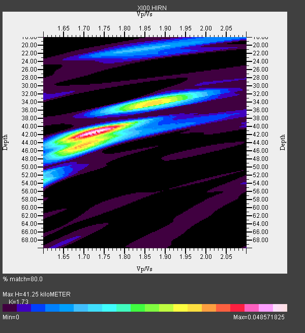
| Thickness Estimate: | 41 km |
| Thickness StdDev: | 5.2 km |
| Vp/Vs Estimate: | 1.73 |
| Vp/Vs StdDev: | 0.05 |
| Vs Estimate: | 3.84 km/s |
| Poisson's Ratio: | 0.25 |
| Peak Value: | 0.05 |
| Assumed Vp: | 6.643 km/s |
| Ps Weight: | 0.33333334 |
| PpPs Weight: | 0.33333334 |
| PsPs Weight: | 0.33333328 |
| Residual Complexity: | 0.623 |
| Nearby stations H: | +- |
| (2.0 deg) Vp/Vs: | +- |
4 with match > 90% ( 66.666664 %) and 6 with match > 80% ( 100.0 %) out of 6.
Download stack as xyz text file.
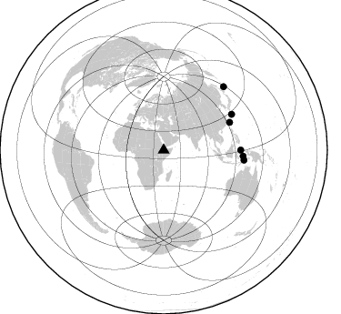
Azimuth Distribution of Events:
Prior Results for this Station
| Study | Thickness | Vp/Vs | Vp | Vs | Poissons Ratio | Extra |
| EARS | 41 km | 1.73 | 6.643 km/s | 3.84 km/s | 0.25 | |
| Crust2.0 | 23 km | 1.77 | 6.643 km/s | 3.757 km/s | 0.26 | IG,very thin late Proter., no seds. |
| Global Maxima | 41 km | 1.73 | 6.643 km/s | 3.84 km/s | 0.25 | amp=0.048571825 |
| Local Maxima 1 | 34 km | 1.88 | 6.643 km/s | 3.543 km/s | 0.30 | amp=0.030886492 |
| Local Maxima 2 | 44 km | 1.71 | 6.643 km/s | 3.896 km/s | 0.24 | amp=0.024826858 |
| Local Maxima 3 | 53 km | 1.60 | 6.643 km/s | 4.152 km/s | 0.18 | amp=0.01559802 |
| Local Maxima 4 | 21 km | 1.82 | 6.643 km/s | 3.66 km/s | 0.28 | amp=0.013584901 |
| Predicted Arrivals for vertical incidence (zero ray parameter) | |
| Ps | 4.53 SECOND |
| PpPs | 16.95 SECOND |
| PsPs/PpSs | 21.48 SECOND |
Events Processed for this Station
Download zip of receiver functions as SAC
Plot maxima for each earthquake.
Events Used in the Stack
(6 events)| Radial Match | Distance | Baz | FERegion | Time | Lat/Lon | Depth | Magnitude |
| 97.86381 | 78.7 deg | 67.368 deg | Taiwan Region | 2001/12/18 04:02:58 GMT | (24.0, 122.7) | 14 km | 6.3 MB, 7.3 MS, 6.9 MW, 6.8 MW |
| 95.27829 | 87.6 deg | 94.446 deg | Banda Sea | 2001/03/19 05:52:15 GMT | (-4.0, 128.0) | 33 km | 6.0 MB, 6.5 MS, 6.5 MW, 6.5 MW |
| 94.67557 | 84.4 deg | 62.396 deg | Ryukyu Islands, Japan | 2001/12/08 20:29:34 GMT | (28.3, 129.6) | 33 km | 5.7 MB, 5.7 MS, 6.2 MW, 6.1 MW |
| 93.10243 | 95.7 deg | 43.585 deg | Kuril Islands | 2001/05/25 00:40:50 GMT | (44.3, 148.4) | 33 km | 6.1 MB, 6.7 MS, 6.7 MW, 6.6 MW |
| 85.332886 | 88.9 deg | 97.096 deg | Banda Sea | 2001/11/20 21:08:18 GMT | (-6.9, 128.9) | 33 km | 5.7 MB, 6.0 MS, 6.3 MW, 6.2 MW |
| 84.0936 | 84.8 deg | 89.992 deg | Northern Molucca Sea | 2001/10/13 16:27:00 GMT | (0.8, 126.0) | 33 km | 5.6 MB, 5.7 MS, 6.0 MW, 5.8 MW |
Losers
(0 events)| Radial Match | Distance | Baz | FERegion | Time | Lat/Lon | Depth | Magnitude | Reason |
