
Station XI TERC - TERCHA
Network: XI00 - Ethiopia/Kenya Broadband Seismic Experiment
Nearby stations (2 deg radius)
| Station | Name | (Lat, Lon) | Start / End | Elevation |
| TERC | TERCHA | (7.14, 37.17) | 2001-03-02 / 2002-12-31 | 1390 m |
| Crust2 Type: | X2,Rift, Rio Grande, Baikal, 0.5km sediments |
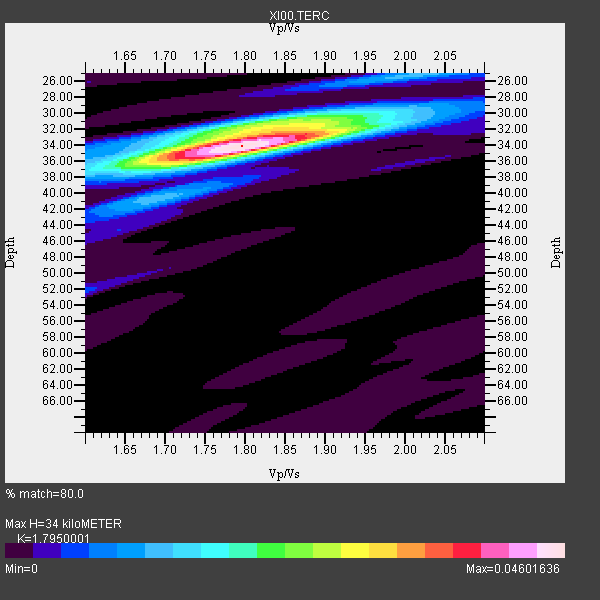
| Thickness Estimate: | 34 km |
| Thickness StdDev: | 0.4 km |
| Vp/Vs Estimate: | 1.80 |
| Vp/Vs StdDev: | 0.02 |
| Vs Estimate: | 3.622 km/s |
| Poisson's Ratio: | 0.27 |
| Peak Value: | 0.05 |
| Assumed Vp: | 6.502 km/s |
| Ps Weight: | 0.33333334 |
| PpPs Weight: | 0.33333334 |
| PsPs Weight: | 0.33333328 |
| Residual Complexity: | 0.467 |
| Nearby stations H: | +- |
| (2.0 deg) Vp/Vs: | +- |
7 with match > 90% ( 36.842106 %) and 19 with match > 80% ( 100.0 %) out of 19.
Download stack as xyz text file.
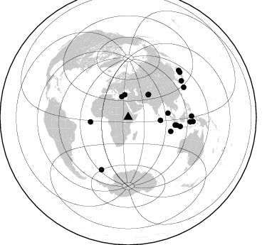
Azimuth Distribution of Events:
Prior Results for this Station
| Study | Thickness | Vp/Vs | Vp | Vs | Poissons Ratio | Extra |
| EARS | 34 km | 1.80 | 6.502 km/s | 3.622 km/s | 0.27 | |
| Crust2.0 | 33 km | 1.77 | 6.502 km/s | 3.68 km/s | 0.26 | X2,Rift, Rio Grande, Baikal, 0.5km sediments |
| Global Maxima | 34 km | 1.80 | 6.502 km/s | 3.622 km/s | 0.27 | amp=0.04601636 |
| Local Maxima 1 | 32 km | 1.84 | 6.502 km/s | 3.529 km/s | 0.29 | amp=0.021486584 |
| Local Maxima 2 | 25 km | 2.02 | 6.502 km/s | 3.215 km/s | 0.34 | amp=0.0117168445 |
| Local Maxima 3 | 36 km | 1.66 | 6.502 km/s | 3.911 km/s | 0.22 | amp=0.010716732 |
| Local Maxima 4 | 32 km | 1.76 | 6.502 km/s | 3.694 km/s | 0.26 | amp=0.009366187 |
| Predicted Arrivals for vertical incidence (zero ray parameter) | |
| Ps | 4.16 SECOND |
| PpPs | 14.62 SECOND |
| PsPs/PpSs | 18.77 SECOND |
Events Processed for this Station
Download zip of receiver functions as SAC
Plot maxima for each earthquake.
Events Used in the Stack
(19 events)| Radial Match | Distance | Baz | FERegion | Time | Lat/Lon | Depth | Magnitude |
| 93.967514 | 53.3 deg | 262.692 deg | North Of Ascension Island | 2001/11/15 01:03:06 GMT | (-1.6, -15.6) | 10 km | 5.5 MB, 6.0 MS, 6.3 MW, 6.3 MW |
| 93.20528 | 87.3 deg | 94.452 deg | Banda Sea | 2001/10/19 03:28:44 GMT | (-4.1, 123.9) | 33 km | 6.3 MB, 7.3 MS, 7.5 MW, 7.4 MW |
| 92.90485 | 90.5 deg | 55.728 deg | Western Honshu, Japan | 2001/03/24 06:27:53 GMT | (34.1, 132.5) | 50 km | 6.4 MB, 6.5 MS, 6.8 MW, 6.4 ME |
| 92.81414 | 42.0 deg | 41.895 deg | Hindu Kush Region, Afghanistan | 2002/01/03 07:05:27 GMT | (36.1, 70.7) | 129 km | 5.8 MB, 6.2 MW, 6.1 MW |
| 92.74903 | 91.3 deg | 93.868 deg | Banda Sea | 2001/03/19 05:52:15 GMT | (-4.0, 128.0) | 33 km | 6.0 MB, 6.5 MS, 6.5 MW, 6.5 MW |
| 91.43657 | 42.8 deg | 42.086 deg | Afghanistan-Tajikistan Bord Reg. | 2001/11/23 20:43:03 GMT | (36.4, 71.5) | 106 km | 5.9 MB, 6.1 MW, 6.0 MW |
| 90.398056 | 69.2 deg | 99.506 deg | Sunda Strait, Indonesia | 2002/01/15 07:12:58 GMT | (-6.3, 105.2) | 10 km | 5.8 MB, 6.3 MS, 6.2 MW, 6.1 MW |
| 88.905014 | 89.1 deg | 89.025 deg | Northern Molucca Sea | 2001/08/27 01:16:47 GMT | (1.1, 126.4) | 33 km | 5.8 MB, 5.9 MS, 6.1 MW, 5.9 MW |
| 88.84144 | 30.1 deg | 342.725 deg | Crete, Greece | 2002/01/22 04:53:52 GMT | (35.8, 26.6) | 88 km | 6.2 MB, 6.3 MW, 6.2 MW |
| 88.471245 | 56.3 deg | 84.373 deg | Nicobar Islands, India Region | 2001/03/15 01:22:43 GMT | (8.7, 94.0) | 33 km | 5.6 MB, 5.9 MS, 6.0 MW, 6.0 MW |
| 87.9044 | 82.9 deg | 207.001 deg | South Sandwich Islands Region | 2001/04/13 15:33:53 GMT | (-59.7, -25.6) | 26 km | 5.3 MB, 6.0 MS, 6.2 MW, 6.2 MW |
| 87.518 | 66.8 deg | 99.632 deg | Southwest Of Sumatra, Indonesia | 2001/12/29 14:32:22 GMT | (-6.0, 102.8) | 33 km | 5.6 MB, 5.7 MS, 5.8 MW, 5.6 MW |
| 87.18672 | 74.3 deg | 100.216 deg | Java, Indonesia | 2001/05/25 05:06:10 GMT | (-7.9, 110.2) | 143 km | 5.8 MB, 6.3 MW, 6.3 MW |
| 86.52316 | 63.0 deg | 108.619 deg | South Indian Ocean | 2001/09/07 02:45:59 GMT | (-13.2, 97.3) | 10 km | 6.2 MB, 5.8 MS, 6.0 MW, 5.9 MW |
| 84.919945 | 31.7 deg | 351.184 deg | Turkey | 2002/02/03 07:11:28 GMT | (38.6, 31.3) | 5.0 km | 5.7 MB, 6.4 MS, 6.5 MW, 6.2 MW |
| 84.481255 | 96.6 deg | 47.309 deg | Hokkaido, Japan Region | 2001/08/13 20:11:23 GMT | (41.0, 142.3) | 38 km | 6.0 MB, 6.3 MS, 6.4 MW, 6.3 ME |
| 83.495094 | 96.1 deg | 49.147 deg | Eastern Honshu, Japan | 2001/12/02 13:01:53 GMT | (39.4, 141.1) | 124 km | 6.1 MB, 6.5 MW, 6.5 MW |
| 83.11728 | 45.6 deg | 95.747 deg | North Indian Ocean | 2001/09/02 02:25:54 GMT | (0.9, 82.5) | 10 km | 5.6 MB, 5.8 MS, 6.1 MW, 6.1 MW |
| 82.27013 | 88.8 deg | 61.84 deg | Ryukyu Islands, Japan | 2001/12/08 20:29:34 GMT | (28.3, 129.6) | 33 km | 5.7 MB, 5.7 MS, 6.2 MW, 6.1 MW |
Losers
(0 events)| Radial Match | Distance | Baz | FERegion | Time | Lat/Lon | Depth | Magnitude | Reason |
