
Station XJ CIC - Crystal Ice Cave
Network: XJ00 - Eastern Snake River Plain Experiment
Nearby stations (2 deg radius)
| Station | Name | (Lat, Lon) | Start / End | Elevation |
| CIC | Crystal Ice Cave | (42.95, -113.21) | 2000-07-16 / 2001-12-31 | 1494 m |
| Crust2 Type: | M7,medium thick extended crust, 0.5 km seds. |
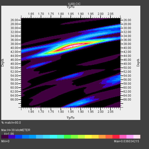
| Thickness Estimate: | 39 km |
| Thickness StdDev: | 3.0 km |
| Vp/Vs Estimate: | 1.86 |
| Vp/Vs StdDev: | 0.02 |
| Vs Estimate: | 3.376 km/s |
| Poisson's Ratio: | 0.30 |
| Peak Value: | 0.04 |
| Assumed Vp: | 6.279 km/s |
| Ps Weight: | 0.33333334 |
| PpPs Weight: | 0.33333334 |
| PsPs Weight: | 0.33333328 |
| Residual Complexity: | 0.463 |
| Nearby stations H: | +- |
| (2.0 deg) Vp/Vs: | +- |
4 with match > 90% ( 26.666666 %) and 15 with match > 80% ( 100.0 %) out of 15.
Download stack as xyz text file.
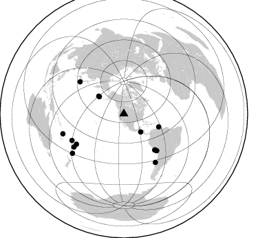
Azimuth Distribution of Events:
Prior Results for this Station
| Study | Thickness | Vp/Vs | Vp | Vs | Poissons Ratio | Extra |
| EARS | 39 km | 1.86 | 6.279 km/s | 3.376 km/s | 0.30 | |
| Crust2.0 | 35 km | 1.78 | 6.279 km/s | 3.533 km/s | 0.27 | M7,medium thick extended crust, 0.5 km seds. |
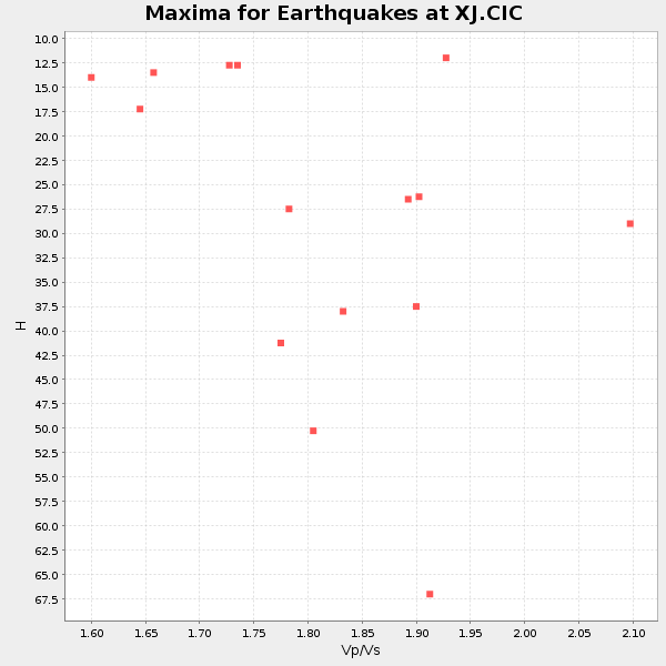
| Global Maxima | 39 km | 1.86 | 6.279 km/s | 3.376 km/s | 0.30 | amp=0.036034215 |
| Local Maxima 1 | 42 km | 1.78 | 6.279 km/s | 3.527 km/s | 0.27 | amp=0.020011038 |
| Local Maxima 2 | 38 km | 1.88 | 6.279 km/s | 3.331 km/s | 0.30 | amp=0.011484657 |
| Local Maxima 3 | 29 km | 2.07 | 6.279 km/s | 3.029 km/s | 0.35 | amp=0.009556442 |
| Local Maxima 4 | 68 km | 1.90 | 6.279 km/s | 3.309 km/s | 0.31 | amp=0.009552872 |
| Predicted Arrivals for vertical incidence (zero ray parameter) | |
| Ps | 5.34 SECOND |
| PpPs | 17.77 SECOND |
| PsPs/PpSs | 23.11 SECOND |
Events Processed for this Station
Download zip of receiver functions as SAC
Plot maxima for each earthquake.
Events Used in the Stack
(15 events)| Radial Match | Distance | Baz | FERegion | Time | Lat/Lon | Depth | Magnitude |
| 96.85689 | 71.1 deg | 138.435 deg | Near Coast Of Peru | 2001/07/07 09:38:43 GMT | (-17.5, -72.1) | 33 km | 6.6 MB, 7.3 MS, 7.6 MW, 7.5 ME |
| 96.01325 | 69.2 deg | 139.125 deg | Near Coast Of Peru | 2001/06/23 20:33:14 GMT | (-16.3, -73.6) | 33 km | 6.7 MB, 8.2 MS, 8.4 MW, 7.8 ME |
| 93.75663 | 71.5 deg | 138.173 deg | Near Coast Of Peru | 2001/06/26 04:18:31 GMT | (-17.7, -71.6) | 24 km | 6.2 MB, 6.7 MS, 6.8 MW, 6.7 ME |
| 91.905556 | 81.7 deg | 237.411 deg | Tonga Islands | 2000/09/26 06:17:52 GMT | (-17.2, -173.9) | 56 km | 6.1 MB, 6.1 MS, 6.4 MW, 6.1 ME |
| 89.9868 | 83.7 deg | 146.866 deg | Off Coast Of Central Chile | 2001/04/09 09:00:57 GMT | (-32.7, -73.1) | 11 km | 6.1 MB, 6.3 MS, 6.7 MW, 6.3 ME |
| 89.833626 | 68.9 deg | 139.339 deg | Near Coast Of Peru | 2001/07/05 13:53:48 GMT | (-16.1, -74.0) | 62 km | 6.2 MB, 6.6 MW, 6.5 ME |
| 86.831795 | 54.1 deg | 110.361 deg | Windward Islands | 2000/10/04 14:37:44 GMT | (11.1, -62.6) | 110 km | 5.6 MB, 5.4 MS, 6.1 MW, 5.9 MD |
| 86.431885 | 93.1 deg | 251.966 deg | Vanuatu Islands | 2000/10/04 16:58:44 GMT | (-15.4, 166.9) | 23 km | 6.1 MB, 6.9 MS, 6.8 MW, 6.5 ME |
| 85.5923 | 86.9 deg | 236.442 deg | Fiji Islands Region | 2001/07/04 07:06:31 GMT | (-21.7, -176.7) | 185 km | 5.9 MB, 5.8 MS, 6.5 MW, 6.5 MW |
| 84.80578 | 78.8 deg | 306.0 deg | Southeast Of Honshu, Japan | 2000/07/30 12:25:45 GMT | (33.9, 139.4) | 10 km | 6.0 MB, 6.5 MS, 6.5 MW, 6.5 MW |
| 83.48685 | 35.9 deg | 137.038 deg | El Salvador | 2001/02/13 14:22:05 GMT | (13.7, -88.9) | 10 km | 5.5 MB, 6.5 MS, 6.6 MW, 6.1 MD |
| 83.244125 | 84.6 deg | 242.9 deg | Fiji Islands | 2000/09/14 14:59:57 GMT | (-15.7, 179.8) | 33 km | 5.7 MB, 6.2 MS, 6.3 MW, 6.2 MW |
| 82.99467 | 93.9 deg | 232.499 deg | Kermadec Islands, New Zealand | 2001/06/03 02:41:57 GMT | (-29.7, -178.6) | 178 km | 6.8 MB, 7.2 MW, 7.1 MW |
| 82.840614 | 44.7 deg | 304.734 deg | Andreanof Islands, Aleutian Is. | 2001/06/14 19:48:47 GMT | (51.2, -179.8) | 18 km | 6.0 MB, 6.3 MS, 6.5 MW, 6.1 ML |
| 82.561554 | 43.4 deg | 304.616 deg | Andreanof Islands, Aleutian Is. | 2001/02/01 18:19:30 GMT | (51.4, -177.8) | 33 km | 5.6 MB, 5.6 MS, 6.0 MW, 5.9 MW |
Losers
(0 events)| Radial Match | Distance | Baz | FERegion | Time | Lat/Lon | Depth | Magnitude | Reason |
