
Station XJ LN45 - Noondotu PS
Network: XJ13 - CRAFTI
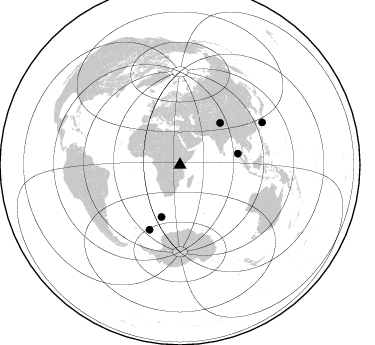
Nearby stations (2 deg radius)
| Station | Name | (Lat, Lon) | Start / End | Elevation |
| LN45 | Noondotu PS | (-2.99, 36.29) | 2013-01-20 / 2014-12-04 | 1063 m |
| Crust2 Type: | X5,thick Rift 0.25 km sediments |
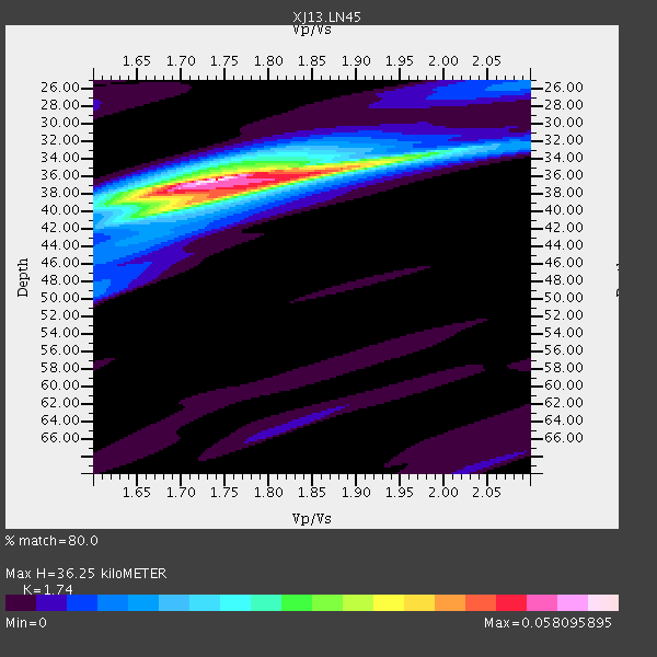
| Thickness Estimate: | 36 km |
| Thickness StdDev: | 0.7 km |
| Vp/Vs Estimate: | 1.74 |
| Vp/Vs StdDev: | 0.04 |
| Vs Estimate: | 3.793 km/s |
| Poisson's Ratio: | 0.25 |
| Peak Value: | 0.06 |
| Assumed Vp: | 6.601 km/s |
| Ps Weight: | 0.33333334 |
| PpPs Weight: | 0.33333334 |
| PsPs Weight: | 0.33333328 |
| Residual Complexity: | 0.496 |
| Nearby stations H: | +- |
| (2.0 deg) Vp/Vs: | +- |
3 with match > 90% ( 10.344828 %) and 5 with match > 80% ( 17.241379 %) out of 29.
Download stack as xyz text file.
Azimuth Distribution of Events:
Prior Results for this Station
| Study | Thickness | Vp/Vs | Vp | Vs | Poissons Ratio | Extra |
| EARS | 36 km | 1.74 | 6.601 km/s | 3.793 km/s | 0.25 | |
| Crust2.0 | 38 km | 1.77 | 6.601 km/s | 3.729 km/s | 0.27 | X5,thick Rift 0.25 km sediments |
| Global Maxima | 36 km | 1.74 | 6.601 km/s | 3.793 km/s | 0.25 | amp=0.058095895 |
| Local Maxima 1 | 37 km | 1.80 | 6.601 km/s | 3.662 km/s | 0.28 | amp=0.0363605 |
| Local Maxima 2 | 40 km | 1.68 | 6.601 km/s | 3.935 km/s | 0.22 | amp=0.0153359 |
| Local Maxima 3 | 34 km | 1.75 | 6.601 km/s | 3.761 km/s | 0.26 | amp=0.011135345 |
| Local Maxima 4 | 49 km | 1.60 | 6.601 km/s | 4.125 km/s | 0.18 | amp=0.009071967 |
| Predicted Arrivals for vertical incidence (zero ray parameter) | |
| Ps | 4.06 SECOND |
| PpPs | 15.05 SECOND |
| PsPs/PpSs | 19.11 SECOND |
Events Processed for this Station
Download zip of receiver functions as SAC
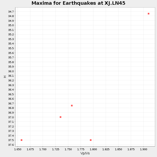
Plot maxima for each earthquake.
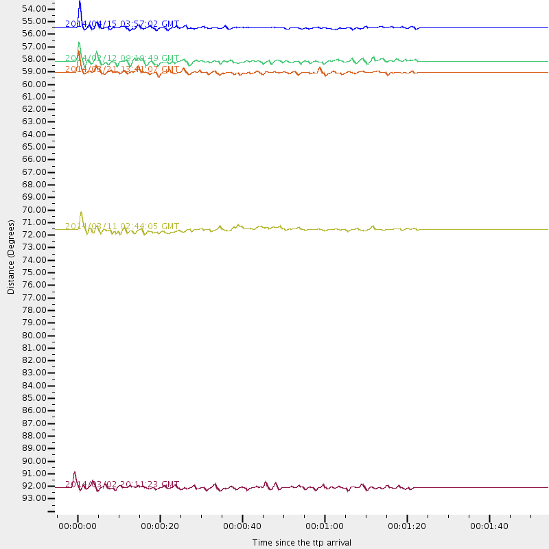
Events Used in the Stack
(5 events)| Radial Match | Distance | Baz | FERegion | Time | Lat/Lon | Depth | Magnitude |
| 96.01891 | 55.2 deg | 199.665 deg | Bouvet Island Region | 2014/04/15 03:57:02 GMT | (-53.5, 8.7) | 12 km | 6.9 MWP, 6.8 MI, 6.9 MI |
| 92.99348 | 58.0 deg | 43.792 deg | Xizang | 2014/02/12 09:19:49 GMT | (35.9, 82.6) | 10 km | 6.9 MWW, 6.9 MWB, 6.9 MWC |
| 92.10085 | 58.9 deg | 79.138 deg | Nicobar Islands, India Region | 2014/03/21 13:41:07 GMT | (7.8, 94.3) | 10 km | 6.5 MWB, 6.4 MWC, 6.4 MWB, 6.4 MWW |
| 87.842896 | 71.5 deg | 205.41 deg | East Of South Sandwich Islands | 2014/03/11 02:44:05 GMT | (-60.9, -20.0) | 10 km | 6.4 MWW, 6.4 MWB, 6.4 MWC, 6.8 MI |
| 83.73579 | 92.3 deg | 62.797 deg | Ryukyu Islands, Japan | 2014/03/02 20:11:23 GMT | (27.4, 127.4) | 119 km | 6.5 MWW, 6.4 MWB, 6.5 MWC, 6.6 MI, 6.7 MI |
Losers
(24 events)| Radial Match | Distance | Baz | FERegion | Time | Lat/Lon | Depth | Magnitude | Reason |
| 94.07831 | 43.6 deg | 341.777 deg | Greece | 2014/02/03 03:08:46 GMT | (38.3, 20.4) | 5.0 km | 6.0 MWW, 6.0 MWB, 6.1 MWC | |
| 77.638824 | 58.7 deg | 79.47 deg | Nicobar Islands, India Region | 2014/03/21 14:25:10 GMT | (7.5, 94.2) | 17 km | 5.5 MW | |
| 65.10375 | 89.0 deg | 78.797 deg | Leyte, Philippines | 2014/01/26 02:41:40 GMT | (11.2, 124.6) | 13 km | 5.0 MW | |
| 62.60115 | 93.4 deg | 93.221 deg | Seram, Indonesia | 2014/03/14 03:22:33 GMT | (-3.1, 129.8) | 25 km | 5.2 MW | |
| 61.7863 | 96.3 deg | 56.606 deg | Kyushu, Japan | 2014/03/13 17:06:50 GMT | (33.7, 131.8) | 79 km | 6.3 MWW, 6.3 MWB, 6.3 MWC | |
| 59.92358 | 59.6 deg | 215.569 deg | Southern Mid-Atlantic Ridge | 2014/04/01 23:13:05 GMT | (-46.8, -10.6) | 10 km | 5.6 MW | |
| 59.678867 | 87.5 deg | 65.858 deg | Taiwan Region | 2014/03/19 12:19:24 GMT | (24.1, 122.3) | 10 km | 5.6 MWB, 5.8 MWW, 5.8 MWC | |
| 56.282772 | 73.8 deg | 206.754 deg | South Sandwich Islands Region | 2014/03/19 20:17:43 GMT | (-60.7, -25.3) | 10 km | 5.5 MWW, 5.4 MWB, 5.5 MWC | |
| 55.33991 | 71.2 deg | 205.297 deg | East Of South Sandwich Islands | 2014/03/08 18:29:08 GMT | (-60.8, -19.3) | 10 km | 5.4 MW | |
| 55.327877 | 73.3 deg | 212.388 deg | South Sandwich Islands Region | 2014/04/17 23:13:04 GMT | (-55.5, -28.2) | 26 km | 5.2 MW | |
| 50.386017 | 91.3 deg | 88.289 deg | Halmahera, Indonesia | 2014/03/26 20:47:51 GMT | (1.8, 127.5) | 151 km | 5.5 MB, 5.4 MWW, 5.5 MWC | |
| 49.19416 | 58.6 deg | 50.312 deg | Xizang | 2014/03/30 17:10:14 GMT | (31.3, 86.5) | 13 km | 5.3 MW | |
| 48.795406 | 92.5 deg | 96.748 deg | Banda Sea | 2014/02/06 20:29:08 GMT | (-6.6, 129.1) | 210 km | 5.0 MW | |
| 48.73282 | 87.0 deg | 85.356 deg | Celebes Sea | 2014/04/17 04:38:17 GMT | (4.5, 123.0) | 567 km | 5.5 MWP | |
| 48.407467 | 71.6 deg | 59.192 deg | Sichuan, China | 2014/04/04 22:40:34 GMT | (28.1, 103.6) | 19 km | 4.9 MW | |
| 48.155125 | 91.7 deg | 97.491 deg | Banda Sea | 2014/02/04 01:05:34 GMT | (-7.4, 128.4) | 35 km | 5.1 MW | |
| 45.944263 | 91.6 deg | 97.282 deg | Banda Sea | 2014/02/04 00:27:09 GMT | (-7.2, 128.3) | 35 km | 5.0 mb | |
| 44.44274 | 91.6 deg | 97.294 deg | Banda Sea | 2014/02/03 20:37:18 GMT | (-7.2, 128.2) | 35 km | 5.0 MW | |
| 43.734005 | 57.9 deg | 43.695 deg | Xizang | 2014/02/11 02:14:56 GMT | (35.9, 82.4) | 8.1 km | 5.3 MW | |
| 43.65329 | 93.8 deg | 97.095 deg | Banda Sea | 2014/01/18 09:34:21 GMT | (-6.9, 130.4) | 150 km | 4.7 mb | |
| 43.59848 | 85.4 deg | 71.247 deg | Luzon, Philippines | 2014/02/17 05:55:59 GMT | (18.5, 120.4) | 20 km | 5.5 MWW, 5.5 MWB, 5.6 MWC | |
| 42.652435 | 54.7 deg | 199.443 deg | Southwest Of Africa | 2014/03/08 07:14:09 GMT | (-53.2, 9.5) | 10 km | 5.4 MW | |
| 40.25222 | 86.4 deg | 76.358 deg | Mindoro, Philippines | 2014/01/26 17:57:45 GMT | (13.5, 121.9) | 30 km | 5.1 MW | |
| 32.54464 | 64.0 deg | 92.977 deg | Southwest Of Sumatra, Indonesia | 2014/03/15 09:37:28 GMT | (-4.0, 100.4) | 25 km | 5.5 MW |

