
Station XJ KEEN - Keene Valley, NY
Network: XJ95 - Adirondack Broadband Array
Nearby stations (2 deg radius)
| Station | Name | (Lat, Lon) | Start / End | Elevation |
| KEEN | Keene Valley, NY | (44.26, -73.82) | 1995-05-09 / 1996-12-31 | 485 m |
| Crust2 Type: | Q2,orogen/39km no ice, Appalachians, North Andes, 0.5 km seds. |
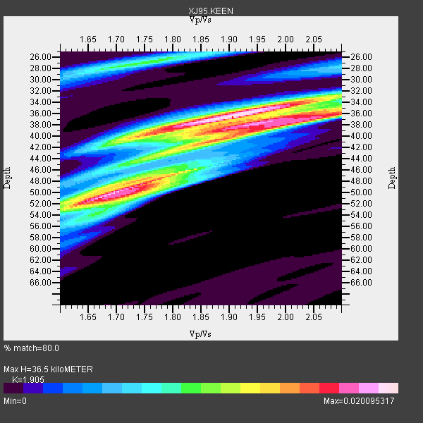
| Thickness Estimate: | 36 km |
| Thickness StdDev: | 6.5 km |
| Vp/Vs Estimate: | 1.90 |
| Vp/Vs StdDev: | 0.13 |
| Vs Estimate: | 3.37 km/s |
| Poisson's Ratio: | 0.31 |
| Peak Value: | 0.02 |
| Assumed Vp: | 6.419 km/s |
| Ps Weight: | 0.33333334 |
| PpPs Weight: | 0.33333334 |
| PsPs Weight: | 0.33333328 |
| Residual Complexity: | 0.799 |
| Nearby stations H: | +- |
| (2.0 deg) Vp/Vs: | +- |
6 with match > 90% ( 23.076923 %) and 12 with match > 80% ( 46.153847 %) out of 26.
Download stack as xyz text file.
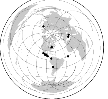
Azimuth Distribution of Events:
Prior Results for this Station
| Study | Thickness | Vp/Vs | Vp | Vs | Poissons Ratio | Extra |
| EARS | 36 km | 1.90 | 6.419 km/s | 3.37 km/s | 0.31 | |
| Crust2.0 | 39 km | 1.75 | 6.419 km/s | 3.659 km/s | 0.26 | Q2,orogen/39km no ice, Appalachians, North Andes, 0.5 km seds. |
| Global Maxima | 36 km | 1.90 | 6.419 km/s | 3.37 km/s | 0.31 | amp=0.020095317 |
| Local Maxima 1 | 50 km | 1.70 | 6.419 km/s | 3.787 km/s | 0.23 | amp=0.019277714 |
| Local Maxima 2 | 37 km | 2.02 | 6.419 km/s | 3.182 km/s | 0.34 | amp=0.017515937 |
| Local Maxima 3 | 40 km | 1.75 | 6.419 km/s | 3.663 km/s | 0.26 | amp=0.011300245 |
| Local Maxima 4 | 47 km | 1.77 | 6.419 km/s | 3.632 km/s | 0.26 | amp=0.010392013 |
| Predicted Arrivals for vertical incidence (zero ray parameter) | |
| Ps | 5.15 SECOND |
| PpPs | 16.52 SECOND |
| PsPs/PpSs | 21.66 SECOND |
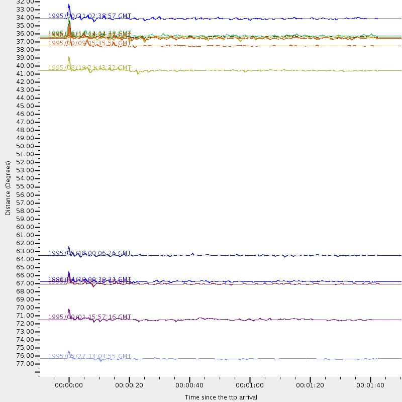
Events Processed for this Station
Download zip of receiver functions as SAC
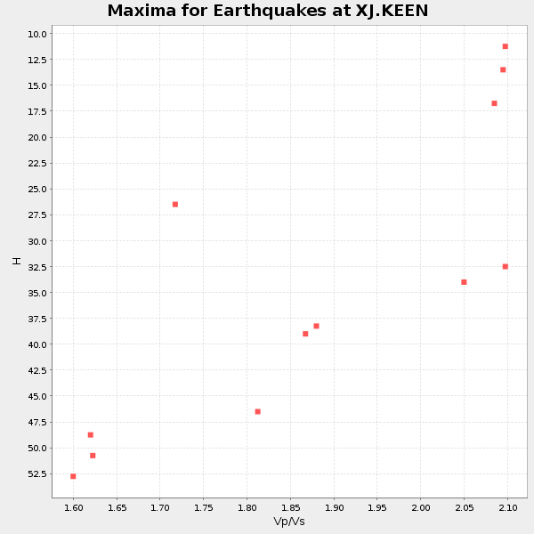
Plot maxima for each earthquake.
Events Used in the Stack
(12 events)| Radial Match | Distance | Baz | FERegion | Time | Lat/Lon | Depth | Magnitude |
| 97.63927 | 68.3 deg | 57.255 deg | Greece | 1995/06/15 00:15:48 GMT | (38.4, 22.3) | 14 km | 6.0 MB, 6.5 MS, 6.5 UNKNOWN, 5.7 ML |
| 97.23082 | 34.4 deg | 225.248 deg | Near Coast Of Guerrero, Mexico | 1995/09/14 14:04:31 GMT | (16.8, -98.6) | 21 km | 6.4 MB, 7.2 MS, 7.2 UNKNOWN, 7.5 MW |
| 95.30016 | 78.5 deg | 338.179 deg | Sakhalin, Russia | 1995/05/27 13:03:55 GMT | (52.6, 142.8) | 33 km | 6.6 MB, 7.6 MS, 7.0 UNKNOWN, 7.0 MW |
| 94.69999 | 35.6 deg | 235.163 deg | Near Coast Of Jalisco, Mexico | 1995/10/09 15:35:55 GMT | (19.1, -104.2) | 49 km | 6.5 MB, 7.3 MS, 7.3 UNKNOWN, 7.9 MW |
| 94.07099 | 31.9 deg | 217.458 deg | Chiapas, Mexico | 1995/10/21 02:38:57 GMT | (16.9, -93.5) | 161 km | 6.2 MB, 7.3 UNKNOWN, 7.3 MW |
| 90.01737 | 68.0 deg | 176.319 deg | Near Coast Of Northern Chile | 1996/04/19 00:19:31 GMT | (-23.9, -70.1) | 50 km | 6.0 MB, 6.1 MS, 6.6 UNKNOWN, 6.5 ME |
| 88.9704 | 34.3 deg | 205.795 deg | Off Coast Of Central America | 1995/06/14 11:11:49 GMT | (12.2, -88.3) | 39 km | 5.6 MB, 6.0 MS, 6.6 UNKNOWN |
| 86.643776 | 64.4 deg | 119.322 deg | Central Mid-Atlantic Ridge | 1995/05/18 00:06:26 GMT | (-0.9, -22.0) | 10 km | 6.2 MB, 6.1 MS, 6.8 UNKNOWN, 6.7 MW |
| 85.14567 | 39.0 deg | 182.955 deg | Colombia | 1995/08/19 21:43:32 GMT | (5.1, -75.7) | 125 km | 6.1 MB, 6.6 UNKNOWN, 6.5 MW |
| 83.26343 | 34.6 deg | 222.47 deg | Near Coast Of Oaxaca, Mexico | 1996/03/19 17:12:43 GMT | (15.9, -97.3) | 33 km | 5.8 MB, 5.2 MS |
| 82.077354 | 34.6 deg | 204.88 deg | Near Coast Of Nicaragua | 1996/03/27 20:52:06 GMT | (11.8, -87.9) | 33 km | 5.5 MB, 5.5 MS, 5.9 UNKNOWN, 5.4 MS |
| 80.00228 | 73.1 deg | 53.128 deg | Turkey | 1995/10/01 15:57:16 GMT | (38.1, 30.2) | 33 km | 5.7 MB, 6.1 MS, 6.3 UNKNOWN, 6.0 MW |
Losers
(14 events)| Radial Match | Distance | Baz | FERegion | Time | Lat/Lon | Depth | Magnitude | Reason |
| 75.74166 | 66.8 deg | 56.11 deg | Greece | 1995/05/13 08:47:12 GMT | (40.1, 21.7) | 13 km | 6.2 MB, 6.5 MS, 6.6 UNKNOWN, 6.5 MD | |
| 75.1884 | 82.7 deg | 330.55 deg | Kuril Islands | 1996/02/07 21:36:45 GMT | (45.3, 149.9) | 33 km | 6.3 MB, 7.0 MS, 7.2 UNKNOWN, 7.1 MW | |
| 74.85129 | 35.8 deg | 234.566 deg | Near Coast Of Jalisco, Mexico | 1995/10/12 16:52:54 GMT | (18.8, -104.0) | 25 km | 5.5 MB, 5.5 MS, 5.2 UNKNOWN, 6.0 MW | |
| 73.94632 | 78.1 deg | 329.705 deg | Kuril Islands | 1995/06/29 07:45:09 GMT | (48.8, 154.5) | 62 km | 5.9 MB, 6.0 UNKNOWN, 6.0 MW | |
| 68.13754 | 59.3 deg | 314.528 deg | Fox Islands, Aleutian Islands | 1996/03/30 13:05:17 GMT | (52.2, -168.7) | 33 km | 5.9 MB, 6.2 MS, 6.3 UNKNOWN, 6.1 ML | |
| 62.79185 | 84.6 deg | 206.081 deg | Southern East Pacific Rise | 1995/10/12 23:41:45 GMT | (-35.4, -106.2) | 10 km | 5.5 MB, 5.3 MS, 5.9 UNKNOWN | |
| 62.36067 | 97.2 deg | 334.478 deg | Near S. Coast Of Honshu, Japan | 1995/07/07 21:15:18 GMT | (33.9, 137.1) | 324 km | 5.8 MB, 6.0 UNKNOWN, 6.0 MW | |
| 61.471077 | 65.3 deg | 174.782 deg | Chile-Bolivia Border Region | 1995/09/19 03:31:53 GMT | (-21.2, -68.7) | 110 km | 5.7 MB, 5.7 UNKNOWN, 5.6 MW | |
| 55.19833 | 45.3 deg | 186.92 deg | Ecuador | 1996/03/28 23:03:49 GMT | (-1.0, -78.7) | 33 km | 5.8 MB, 5.2 MS, 5.9 UNKNOWN, 5.1 MS | |
| 53.518627 | 67.3 deg | 176.78 deg | Near Coast Of Northern Chile | 1995/07/30 21:05:50 GMT | (-23.3, -70.6) | 33 km | 5.6 MB, 5.6 MS, 5.4 UNKNOWN, 6.1 MW | |
| 52.85912 | 84.9 deg | 331.202 deg | Kuril Islands | 1996/05/07 23:20:00 GMT | (43.7, 147.6) | 54 km | 6.2 MB, 5.6 MS, 6.2 UNKNOWN, 5.2 MS | |
| 50.333275 | 55.9 deg | 314.017 deg | Unimak Island Region, Alaska | 1995/07/08 17:15:28 GMT | (53.6, -163.5) | 33 km | 5.8 MB, 5.7 MS, 5.5 UNKNOWN, 6.0 MW | |
| 44.452133 | 66.8 deg | 56.226 deg | Greece | 1995/05/15 04:13:55 GMT | (40.0, 21.6) | 10 km | 5.5 MD, 5.1 MB | |
| 37.8258 | 67.2 deg | 176.76 deg | Near Coast Of Northern Chile | 1995/08/02 00:14:09 GMT | (-23.2, -70.6) | 33 km | 5.4 MB, 5.5 MS, 5.3 UNKNOWN |
