
Station XJ PACK - Pack State Forest, NY
Network: XJ95 - Adirondack Broadband Array
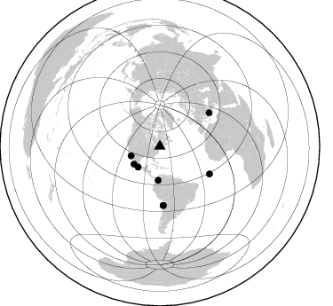
Nearby stations (2 deg radius)
| Station | Name | (Lat, Lon) | Start / End | Elevation |
| PACK | Pack State Forest, NY | (43.53, -73.82) | 1995-05-04 / 1996-12-31 | 287 m |
| Crust2 Type: | Q2,orogen/39km no ice, Appalachians, North Andes, 0.5 km seds. |
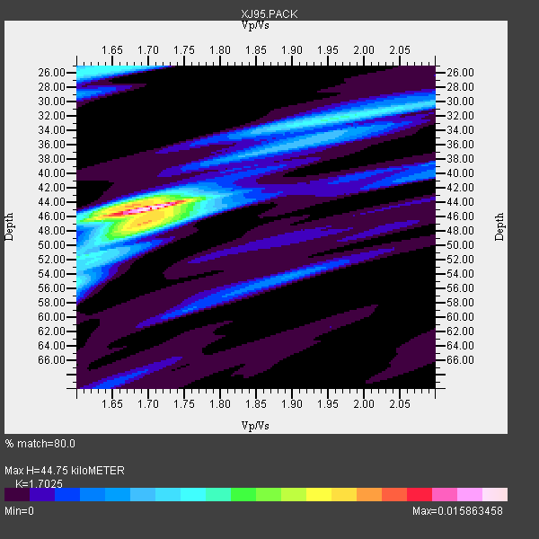
| Thickness Estimate: | 45 km |
| Thickness StdDev: | 5.8 km |
| Vp/Vs Estimate: | 1.70 |
| Vp/Vs StdDev: | 0.10 |
| Vs Estimate: | 3.77 km/s |
| Poisson's Ratio: | 0.24 |
| Peak Value: | 0.02 |
| Assumed Vp: | 6.419 km/s |
| Ps Weight: | 0.33333334 |
| PpPs Weight: | 0.33333334 |
| PsPs Weight: | 0.33333328 |
| Residual Complexity: | 0.586 |
| Nearby stations H: | +- |
| (2.0 deg) Vp/Vs: | +- |
3 with match > 90% ( 21.428572 %) and 8 with match > 80% ( 57.142857 %) out of 14.
Download stack as xyz text file.
Azimuth Distribution of Events:
Prior Results for this Station
| Study | Thickness | Vp/Vs | Vp | Vs | Poissons Ratio | Extra |
| EARS | 45 km | 1.70 | 6.419 km/s | 3.77 km/s | 0.24 | |
| Crust2.0 | 39 km | 1.75 | 6.419 km/s | 3.659 km/s | 0.26 | Q2,orogen/39km no ice, Appalachians, North Andes, 0.5 km seds. |
| Global Maxima | 45 km | 1.70 | 6.419 km/s | 3.77 km/s | 0.24 | amp=0.015863458 |
| Local Maxima 1 | 47 km | 1.70 | 6.419 km/s | 3.787 km/s | 0.23 | amp=0.007906638 |
| Local Maxima 2 | 25 km | 1.66 | 6.419 km/s | 3.867 km/s | 0.22 | amp=0.0061697857 |
| Local Maxima 3 | 44 km | 1.66 | 6.419 km/s | 3.873 km/s | 0.21 | amp=0.006100901 |
| Local Maxima 4 | 32 km | 1.96 | 6.419 km/s | 3.279 km/s | 0.32 | amp=0.005865467 |
| Predicted Arrivals for vertical incidence (zero ray parameter) | |
| Ps | 4.90 SECOND |
| PpPs | 18.84 SECOND |
| PsPs/PpSs | 23.74 SECOND |
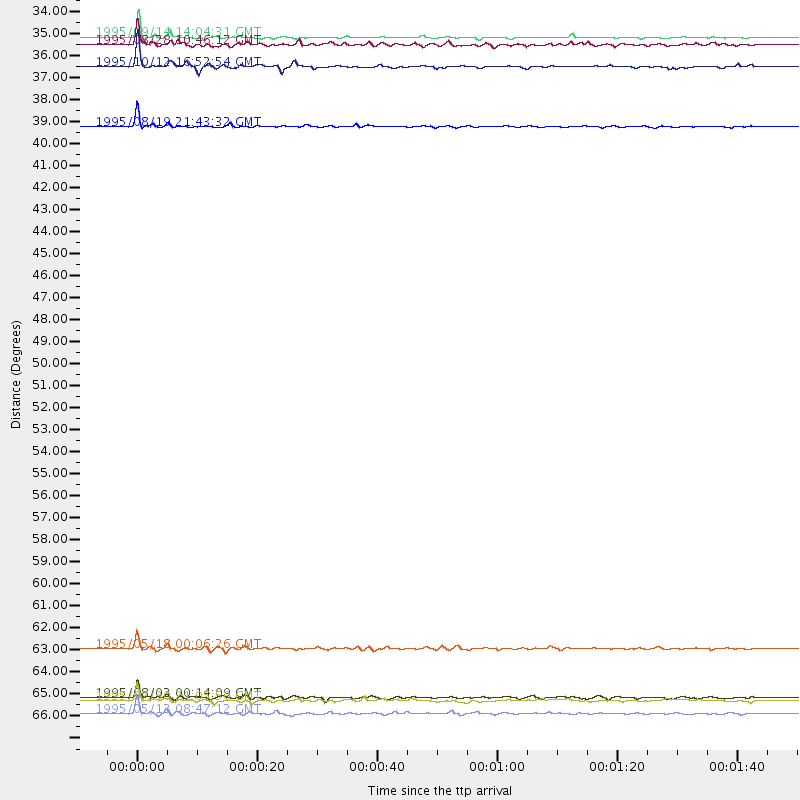
Events Processed for this Station
Download zip of receiver functions as SAC
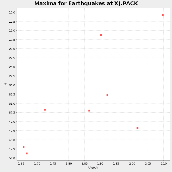
Plot maxima for each earthquake.
Events Used in the Stack
(8 events)| Radial Match | Distance | Baz | FERegion | Time | Lat/Lon | Depth | Magnitude |
| 98.49079 | 33.9 deg | 226.022 deg | Near Coast Of Guerrero, Mexico | 1995/09/14 14:04:31 GMT | (16.8, -98.6) | 21 km | 6.4 MB, 7.2 MS, 7.2 UNKNOWN, 7.5 MW |
| 96.141304 | 38.3 deg | 183.008 deg | Colombia | 1995/08/19 21:43:32 GMT | (5.1, -75.7) | 125 km | 6.1 MB, 6.6 UNKNOWN, 6.5 MW |
| 92.95794 | 67.2 deg | 55.855 deg | Greece | 1995/05/13 08:47:12 GMT | (40.1, 21.7) | 13 km | 6.2 MB, 6.5 MS, 6.6 UNKNOWN, 6.5 MD |
| 89.837296 | 35.4 deg | 235.407 deg | Near Coast Of Jalisco, Mexico | 1995/10/12 16:52:54 GMT | (18.8, -104.0) | 25 km | 5.5 MB, 5.5 MS, 5.2 UNKNOWN, 6.0 MW |
| 88.682495 | 64.0 deg | 119.018 deg | Central Mid-Atlantic Ridge | 1995/05/18 00:06:26 GMT | (-0.9, -22.0) | 10 km | 6.2 MB, 6.1 MS, 6.8 UNKNOWN, 6.7 MW |
| 86.12064 | 34.3 deg | 251.713 deg | Gulf Of California | 1995/08/28 10:46:12 GMT | (26.2, -110.3) | 10 km | 5.6 MB, 6.5 MS |
| 83.897095 | 66.4 deg | 176.746 deg | Near Coast Of Northern Chile | 1995/08/02 00:14:09 GMT | (-23.2, -70.6) | 33 km | 5.4 MB, 5.5 MS, 5.3 UNKNOWN |
| 83.272766 | 66.6 deg | 176.766 deg | Near Coast Of Northern Chile | 1995/07/30 21:05:50 GMT | (-23.3, -70.6) | 33 km | 5.6 MB, 5.6 MS, 5.4 UNKNOWN, 6.1 MW |
Losers
(6 events)| Radial Match | Distance | Baz | FERegion | Time | Lat/Lon | Depth | Magnitude | Reason |
| 72.10749 | 93.8 deg | 12.993 deg | Southern Xinjiang, China | 1995/08/17 00:59:57 GMT | (41.6, 88.8) | 0.0 km | 6.0 MB | |
| 65.45817 | 84.3 deg | 330.708 deg | Kuril Islands | 1995/11/24 17:24:12 GMT | (44.5, 149.1) | 33 km | 6.1 MB, 6.3 MS, 6.1 UNKNOWN, 6.6 MW | |
| 64.49601 | 56.4 deg | 314.369 deg | Unimak Island Region, Alaska | 1995/07/08 17:15:28 GMT | (53.6, -163.5) | 33 km | 5.8 MB, 5.7 MS, 5.5 UNKNOWN, 6.0 MW | |
| 64.07928 | 64.6 deg | 174.755 deg | Chile-Bolivia Border Region | 1995/09/19 03:31:53 GMT | (-21.2, -68.7) | 110 km | 5.7 MB, 5.7 UNKNOWN, 5.6 MW | |
| 55.58819 | 83.9 deg | 206.116 deg | Southern East Pacific Rise | 1995/10/12 23:41:45 GMT | (-35.4, -106.2) | 10 km | 5.5 MB, 5.3 MS, 5.9 UNKNOWN | |
| 46.965412 | 37.4 deg | 239.696 deg | Off Coast Of Jalisco, Mexico | 1995/05/31 16:08:40 GMT | (18.9, -107.4) | 33 km | 5.4 MB, 6.1 MS, 6.3 UNKNOWN, 6.3 MW |
