
Station XJ BRR - Blackrock Reservior
Network: XJ97 - Sierran Paradox
Nearby stations (2 deg radius)
| Station | Name | (Lat, Lon) | Start / End | Elevation |
| BRR | Blackrock Reservior | (36.91, -119.04) | 1997-07-01 / 1997-12-31 | 1259 m |
| Crust2 Type: | M9,thick extended crust, 0.5 km seds. |
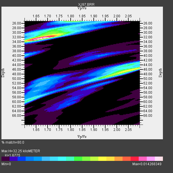
| Thickness Estimate: | 32 km |
| Thickness StdDev: | 8.6 km |
| Vp/Vs Estimate: | 1.68 |
| Vp/Vs StdDev: | 0.11 |
| Vs Estimate: | 3.75 km/s |
| Poisson's Ratio: | 0.22 |
| Peak Value: | 0.01 |
| Assumed Vp: | 6.291 km/s |
| Ps Weight: | 0.33333334 |
| PpPs Weight: | 0.33333334 |
| PsPs Weight: | 0.33333328 |
| Residual Complexity: | 0.757 |
| Nearby stations H: | 30 km +- 2.1 km |
| (2.0 deg) Vp/Vs: | 1.70 +- 0.03 |
6 with match > 90% ( 28.571428 %) and 11 with match > 80% ( 52.38095 %) out of 21.
Download stack as xyz text file.
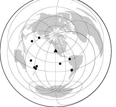
Azimuth Distribution of Events:
Prior Results for this Station
| Study | Thickness | Vp/Vs | Vp | Vs | Poissons Ratio | Extra |
| EARS | 32 km | 1.68 | 6.291 km/s | 3.75 km/s | 0.22 | |
| Crust2.0 | 40 km | 1.78 | 6.291 km/s | 3.539 km/s | 0.27 | M9,thick extended crust, 0.5 km seds. |
| Global Maxima | 32 km | 1.68 | 6.291 km/s | 3.75 km/s | 0.22 | amp=0.014268349 |
| Local Maxima 1 | 46 km | 2.07 | 6.291 km/s | 3.047 km/s | 0.35 | amp=0.009273572 |
| Local Maxima 2 | 25 km | 1.82 | 6.291 km/s | 3.461 km/s | 0.28 | amp=0.007257742 |
| Local Maxima 3 | 49 km | 1.95 | 6.291 km/s | 3.23 km/s | 0.32 | amp=0.006386571 |
| Local Maxima 4 | 59 km | 1.62 | 6.291 km/s | 3.889 km/s | 0.19 | amp=0.0060217413 |
| Predicted Arrivals for vertical incidence (zero ray parameter) | |
| Ps | 3.47 SECOND |
| PpPs | 13.73 SECOND |
| PsPs/PpSs | 17.20 SECOND |
Events Processed for this Station
Download zip of receiver functions as SAC
Plot maxima for each earthquake.
Events Used in the Stack
(11 events)| Radial Match | Distance | Baz | FERegion | Time | Lat/Lon | Depth | Magnitude |
| 94.43832 | 51.5 deg | 119.104 deg | Colombia | 1997/09/02 12:13:22 GMT | (3.8, -75.7) | 199 km | 6.5 MB, 6.8 UNKNOWN, 6.4 ME |
| 91.86748 | 86.3 deg | 232.838 deg | South Of Fiji Islands | 1997/09/04 04:23:37 GMT | (-26.6, 178.3) | 625 km | 6.3 MB, 6.8 UNKNOWN, 6.5 ME |
| 91.26904 | 80.3 deg | 140.053 deg | Near Coast Of Central Chile | 1997/07/27 05:21:29 GMT | (-30.5, -71.9) | 33 km | 5.6 MB, 5.8 MS, 6.3 UNKNOWN, 6.2 MW |
| 90.98101 | 85.3 deg | 228.794 deg | Kermadec Islands Region | 1997/09/20 16:11:32 GMT | (-28.7, -177.6) | 30 km | 6.1 MB, 7.0 MS, 7.2 UNKNOWN, 6.7 ME |
| 90.38344 | 80.0 deg | 139.783 deg | Near Coast Of Central Chile | 1997/07/06 09:54:00 GMT | (-30.1, -71.9) | 19 km | 5.8 MB, 6.5 MS, 6.8 UNKNOWN, 6.4 ME |
| 90.00541 | 68.8 deg | 308.631 deg | Kuril Islands | 1997/07/14 16:09:35 GMT | (43.2, 146.4) | 33 km | 5.9 MB, 5.8 MS, 6.1 UNKNOWN, 5.8 ME |
| 87.71296 | 42.9 deg | 160.251 deg | Central East Pacific Rise | 1997/08/15 07:37:49 GMT | (-4.4, -105.7) | 10 km | 5.3 MB, 5.8 MS, 6.2 UNKNOWN, 6.1 MW |
| 87.44239 | 85.4 deg | 249.342 deg | Vanuatu Islands | 1997/08/17 20:11:10 GMT | (-13.6, 167.4) | 26 km | 5.4 MB, 6.1 MS, 6.1 UNKNOWN, 6.0 MW |
| 85.99901 | 79.4 deg | 139.179 deg | Near Coast Of Central Chile | 1997/07/19 12:22:57 GMT | (-29.3, -71.7) | 26 km | 5.8 MB, 5.5 MS, 5.9 UNKNOWN, 5.8 MW |
| 85.95944 | 78.0 deg | 231.633 deg | Tonga Islands | 1997/09/10 12:57:07 GMT | (-21.3, -174.4) | 10 km | 5.7 MB, 6.1 MS, 6.1 UNKNOWN, 5.9 MW |
| 82.36478 | 83.1 deg | 292.651 deg | Volcano Islands, Japan Region | 1997/07/28 06:46:55 GMT | (22.4, 142.7) | 33 km | 5.7 MB, 5.8 MS, 5.9 UNKNOWN, 5.9 MW |
Losers
(10 events)| Radial Match | Distance | Baz | FERegion | Time | Lat/Lon | Depth | Magnitude | Reason |
| 78.35228 | 88.0 deg | 227.059 deg | Kermadec Islands Region | 1997/10/07 13:15:53 GMT | (-31.8, -178.3) | 33 km | 5.5 MB, 5.6 MS | |
| 72.49612 | 79.7 deg | 234.365 deg | Fiji Islands Region | 1997/08/25 11:59:00 GMT | (-20.8, -177.8) | 394 km | 5.5 UNKNOWN, 5.3 MB | |
| 70.69696 | 93.3 deg | 304.687 deg | Southwestern Ryukyu Isl., Japan | 1997/08/13 04:45:04 GMT | (25.0, 125.8) | 55 km | 6.0 MB, 5.6 MS, 6.1 UNKNOWN, 6.1 MW | |
| 69.03259 | 80.3 deg | 140.051 deg | Near Coast Of Central Chile | 1997/07/25 06:47:02 GMT | (-30.5, -71.9) | 33 km | 5.6 MB, 5.5 MS, 6.3 UNKNOWN | |
| 67.522514 | 85.6 deg | 233.595 deg | South Of Fiji Islands | 1997/08/26 15:22:09 GMT | (-25.5, 178.3) | 610 km | 5.5 MB, 5.7 UNKNOWN | |
| 66.774376 | 82.3 deg | 293.829 deg | Volcano Islands, Japan Region | 1997/07/08 02:24:07 GMT | (23.8, 142.7) | 33 km | 5.8 MB, 5.6 MS, 5.9 UNKNOWN, 5.8 MW | |
| 64.52352 | 88.2 deg | 230.921 deg | Kermadec Islands Region | 1997/10/08 10:47:49 GMT | (-29.2, 178.4) | 617 km | 5.5 MB, 5.7 UNKNOWN | |
| 56.677082 | 95.7 deg | 306.568 deg | Taiwan Region | 1997/07/15 11:05:31 GMT | (24.7, 122.4) | 103 km | 5.6 MB, 5.6 UNKNOWN, 5.6 MW | |
| 54.701614 | 90.8 deg | 263.122 deg | Solomon Islands | 1997/09/07 12:57:06 GMT | (-6.0, 154.5) | 421 km | 5.6 MB, 5.8 UNKNOWN, 5.8 MW | |
| 25.307222 | 95.5 deg | 306.79 deg | Taiwan Region | 1997/10/11 18:24:23 GMT | (25.0, 122.5) | 143 km | 5.5 UNKNOWN, 5.3 MB |
