
Station XJ BVC - Beveridge Canyon
Network: XJ97 - Sierran Paradox
Nearby stations (2 deg radius)
| Station | Name | (Lat, Lon) | Start / End | Elevation |
| BVC | Beveridge Canyon | (36.73, -117.86) | 1997-06-16 / 1997-12-31 | 483 m |
| Crust2 Type: | M7,medium thick extended crust, 0.5 km seds. |
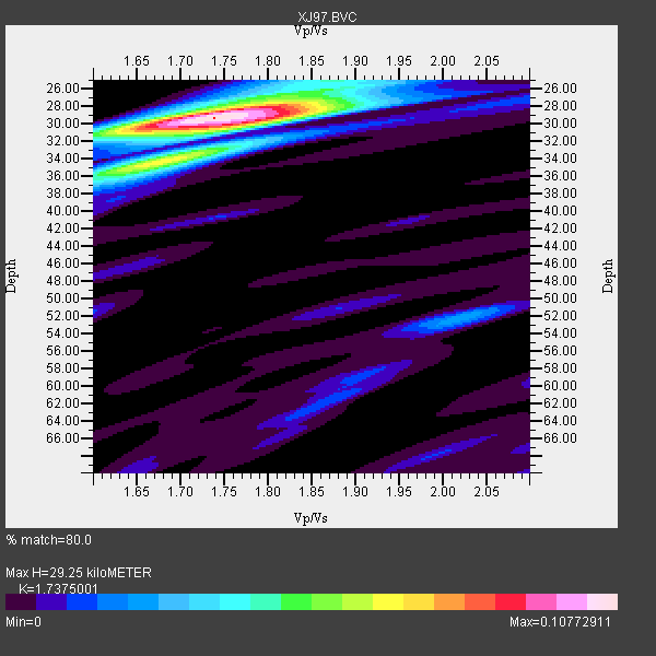
| Thickness Estimate: | 29 km |
| Thickness StdDev: | 0.4 km |
| Vp/Vs Estimate: | 1.74 |
| Vp/Vs StdDev: | 0.04 |
| Vs Estimate: | 3.614 km/s |
| Poisson's Ratio: | 0.25 |
| Peak Value: | 0.11 |
| Assumed Vp: | 6.279 km/s |
| Ps Weight: | 0.33333334 |
| PpPs Weight: | 0.33333334 |
| PsPs Weight: | 0.33333328 |
| Residual Complexity: | 0.469 |
| Nearby stations H: | +- |
| (2.0 deg) Vp/Vs: | +- |
1 with match > 90% ( 8.333333 %) and 5 with match > 80% ( 41.666668 %) out of 12.
Download stack as xyz text file.
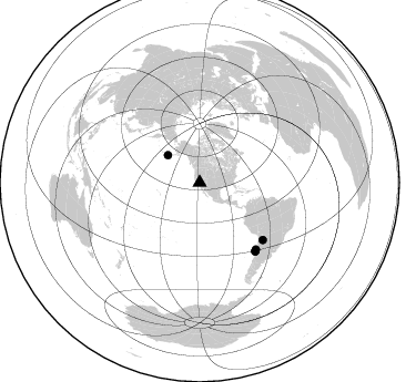
Azimuth Distribution of Events:
Prior Results for this Station
| Study | Thickness | Vp/Vs | Vp | Vs | Poissons Ratio | Extra |
| EARS | 29 km | 1.74 | 6.279 km/s | 3.614 km/s | 0.25 | |
| Crust2.0 | 35 km | 1.78 | 6.279 km/s | 3.533 km/s | 0.27 | M7,medium thick extended crust, 0.5 km seds. |
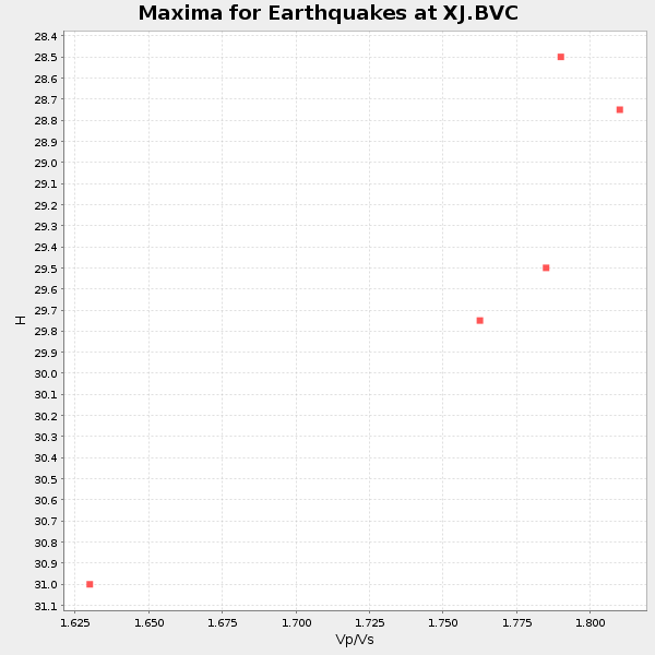
| Global Maxima | 29 km | 1.74 | 6.279 km/s | 3.614 km/s | 0.25 | amp=0.10772911 |
| Local Maxima 1 | 34 km | 1.69 | 6.279 km/s | 3.71 km/s | 0.23 | amp=0.050714385 |
| Local Maxima 2 | 30 km | 1.80 | 6.279 km/s | 3.493 km/s | 0.28 | amp=0.039864834 |
| Local Maxima 3 | 26 km | 1.87 | 6.279 km/s | 3.367 km/s | 0.30 | amp=0.03154339 |
| Local Maxima 4 | 52 km | 2.01 | 6.279 km/s | 3.12 km/s | 0.34 | amp=0.02646167 |
| Predicted Arrivals for vertical incidence (zero ray parameter) | |
| Ps | 3.44 SECOND |
| PpPs | 12.75 SECOND |
| PsPs/PpSs | 16.19 SECOND |
Events Processed for this Station
Download zip of receiver functions as SAC
Plot maxima for each earthquake.
Events Used in the Stack
(5 events)| Radial Match | Distance | Baz | FERegion | Time | Lat/Lon | Depth | Magnitude |
| 91.64507 | 79.6 deg | 140.863 deg | Near Coast Of Central Chile | 1997/07/27 05:21:29 GMT | (-30.5, -71.9) | 33 km | 5.6 MB, 5.8 MS, 6.3 UNKNOWN, 6.2 MW |
| 87.62493 | 79.5 deg | 140.862 deg | Near Coast Of Central Chile | 1997/07/25 06:47:02 GMT | (-30.5, -71.9) | 33 km | 5.6 MB, 5.5 MS, 6.3 UNKNOWN |
| 85.457054 | 76.8 deg | 132.134 deg | Jujuy Province, Argentina | 1997/07/20 10:14:22 GMT | (-23.0, -66.3) | 256 km | 5.7 MB, 6.1 UNKNOWN, 5.7 ME |
| 84.54873 | 78.7 deg | 139.997 deg | Near Coast Of Central Chile | 1997/07/19 12:22:57 GMT | (-29.3, -71.7) | 26 km | 5.8 MB, 5.5 MS, 5.9 UNKNOWN, 5.8 MW |
| 82.57368 | 37.9 deg | 310.76 deg | Fox Islands, Aleutian Islands | 1997/07/20 00:30:20 GMT | (52.6, -167.5) | 14 km | 5.6 MB, 5.9 MS, 6.2 UNKNOWN, 6.2 MW |
Losers
(7 events)| Radial Match | Distance | Baz | FERegion | Time | Lat/Lon | Depth | Magnitude | Reason |
| 78.07195 | 84.0 deg | 293.331 deg | Volcano Islands, Japan Region | 1997/07/28 06:46:55 GMT | (22.4, 142.7) | 33 km | 5.7 MB, 5.8 MS, 5.9 UNKNOWN, 5.9 MW | |
| 77.15427 | 79.2 deg | 140.597 deg | Near Coast Of Central Chile | 1997/07/06 09:54:00 GMT | (-30.1, -71.9) | 19 km | 5.8 MB, 6.5 MS, 6.8 UNKNOWN, 6.4 ME | |
| 76.71764 | 79.4 deg | 140.79 deg | Near Coast Of Central Chile | 1997/07/21 23:19:39 GMT | (-30.3, -71.9) | 33 km | 5.2 MB, 5.5 MS, 6.1 UNKNOWN | |
| 71.40505 | 69.7 deg | 309.163 deg | Kuril Islands | 1997/07/14 16:09:35 GMT | (43.2, 146.4) | 33 km | 5.9 MB, 5.8 MS, 6.1 UNKNOWN, 5.8 ME | |
| 59.11805 | 83.2 deg | 294.503 deg | Volcano Islands, Japan Region | 1997/07/08 02:24:07 GMT | (23.8, 142.7) | 33 km | 5.8 MB, 5.6 MS, 5.9 UNKNOWN, 5.8 MW | |
| 56.54249 | 96.6 deg | 307.315 deg | Taiwan Region | 1997/07/15 11:05:31 GMT | (24.7, 122.4) | 103 km | 5.6 MB, 5.6 UNKNOWN, 5.6 MW | |
| 52.242107 | 45.2 deg | 309.077 deg | Andreanof Islands, Aleutian Is. | 1997/06/17 21:03:40 GMT | (51.3, -179.3) | 33 km | 6.4 MB, 6.3 MS, 6.4 UNKNOWN, 6.6 ML |
