
Station XJ CHP - Chimney Peak
Network: XJ97 - Sierran Paradox
Nearby stations (2 deg radius)
| Station | Name | (Lat, Lon) | Start / End | Elevation |
| CHP | Chimney Peak | (35.89, -118.09) | 1997-06-15 / 1997-12-31 | 2426 m |
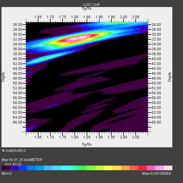
| Crust2 Type: | M1,extended crust, 3 km seds. |
| Thickness Estimate: | 31 km |
| Thickness StdDev: | 1.0 km |
| Vp/Vs Estimate: | 1.81 |
| Vp/Vs StdDev: | 0.02 |
| Vs Estimate: | 3.366 km/s |
| Poisson's Ratio: | 0.28 |
| Peak Value: | 0.09 |
| Assumed Vp: | 6.1 km/s |
| Ps Weight: | 0.33333334 |
| PpPs Weight: | 0.33333334 |
| PsPs Weight: | 0.33333328 |
| Residual Complexity: | 0.459 |
| Nearby stations H: | +- |
| (2.0 deg) Vp/Vs: | +- |
3 with match > 90% ( 37.5 %) and 4 with match > 80% ( 50.0 %) out of 8.
Download stack as xyz text file.
Azimuth Distribution of Events:

Prior Results for this Station
| Study | Thickness | Vp/Vs | Vp | Vs | Poissons Ratio | Extra |
| EARS | 31 km | 1.81 | 6.1 km/s | 3.366 km/s | 0.28 | |
| Crust2.0 | 31 km | 1.78 | 6.1 km/s | 3.426 km/s | 0.27 | M1,extended crust, 3 km seds. |
| Global Maxima | 31 km | 1.81 | 6.1 km/s | 3.366 km/s | 0.28 | amp=0.09185869 |
| Local Maxima 1 | 33 km | 1.81 | 6.1 km/s | 3.375 km/s | 0.28 | amp=0.04730852 |
| Local Maxima 2 | 40 km | 1.68 | 6.1 km/s | 3.636 km/s | 0.22 | amp=0.03160055 |
| Local Maxima 3 | 25 km | 1.92 | 6.1 km/s | 3.181 km/s | 0.31 | amp=0.028518546 |
| Local Maxima 4 | 30 km | 1.86 | 6.1 km/s | 3.288 km/s | 0.30 | amp=0.020029387 |
| Predicted Arrivals for vertical incidence (zero ray parameter) | |
| Ps | 4.16 SECOND |
| PpPs | 14.41 SECOND |
| PsPs/PpSs | 18.57 SECOND |
Events Processed for this Station
Download zip of receiver functions as SAC
Plot maxima for each earthquake.
Events Used in the Stack
(4 events)| Radial Match | Distance | Baz | FERegion | Time | Lat/Lon | Depth | Magnitude |
| 93.74881 | 78.7 deg | 140.331 deg | Near Coast Of Central Chile | 1997/07/06 09:54:00 GMT | (-30.1, -71.9) | 19 km | 5.8 MB, 6.5 MS, 6.8 UNKNOWN, 6.4 ME |
| 91.88581 | 85.2 deg | 229.459 deg | Kermadec Islands Region | 1997/09/20 16:11:32 GMT | (-28.7, -177.6) | 30 km | 6.1 MB, 7.0 MS, 7.2 UNKNOWN, 6.7 ME |
| 91.541245 | 45.6 deg | 309.691 deg | Andreanof Islands, Aleutian Is. | 1997/06/17 21:03:40 GMT | (51.3, -179.3) | 33 km | 6.4 MB, 6.3 MS, 6.4 UNKNOWN, 6.6 ML |
| 89.26377 | 77.9 deg | 232.464 deg | Tonga Islands | 1997/09/10 12:57:07 GMT | (-21.3, -174.4) | 10 km | 5.7 MB, 6.1 MS, 6.1 UNKNOWN, 5.9 MW |
Losers
(4 events)| Radial Match | Distance | Baz | FERegion | Time | Lat/Lon | Depth | Magnitude | Reason |
| 61.96849 | 85.3 deg | 177.706 deg | Southern East Pacific Rise | 1997/06/26 19:21:08 GMT | (-49.7, -114.6) | 10 km | 5.4 MB, 6.0 MS, 6.2 UNKNOWN, 6.1 MW | |
| 56.141666 | 84.5 deg | 308.824 deg | Western Honshu, Japan | 1997/06/25 09:50:12 GMT | (34.4, 131.6) | 10 km | 5.5 MB, 5.6 MS, 5.9 UNKNOWN, 5.8 MW | |
| 54.07092 | 83.4 deg | 294.467 deg | Volcano Islands, Japan Region | 1997/07/08 02:24:07 GMT | (23.8, 142.7) | 33 km | 5.8 MB, 5.6 MS, 5.9 UNKNOWN, 5.8 MW | |
| 45.244705 | 91.4 deg | 263.661 deg | Solomon Islands | 1997/09/07 12:57:06 GMT | (-6.0, 154.5) | 421 km | 5.6 MB, 5.8 UNKNOWN, 5.8 MW |
