
Station XJ CPR - Copper Creek
Network: XJ97 - Sierran Paradox
Nearby stations (2 deg radius)
| Station | Name | (Lat, Lon) | Start / End | Elevation |
| CPR | Copper Creek | (36.80, -118.58) | 1997-05-31 / 1997-12-31 | 1603 m |
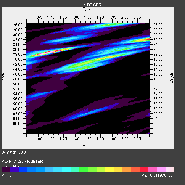
| Crust2 Type: | M9,thick extended crust, 0.5 km seds. |
| Thickness Estimate: | 37 km |
| Thickness StdDev: | 5.7 km |
| Vp/Vs Estimate: | 1.68 |
| Vp/Vs StdDev: | 0.16 |
| Vs Estimate: | 3.739 km/s |
| Poisson's Ratio: | 0.23 |
| Peak Value: | 0.01 |
| Assumed Vp: | 6.291 km/s |
| Ps Weight: | 0.33333334 |
| PpPs Weight: | 0.33333334 |
| PsPs Weight: | 0.33333328 |
| Residual Complexity: | 0.810 |
| Nearby stations H: | +- |
| (2.0 deg) Vp/Vs: | +- |
0 with match > 90% ( 0.0 %) and 6 with match > 80% ( 35.294117 %) out of 17.
Download stack as xyz text file.
Azimuth Distribution of Events:

Prior Results for this Station
| Study | Thickness | Vp/Vs | Vp | Vs | Poissons Ratio | Extra |
| EARS | 37 km | 1.68 | 6.291 km/s | 3.739 km/s | 0.23 | |
| Crust2.0 | 40 km | 1.78 | 6.291 km/s | 3.539 km/s | 0.27 | M9,thick extended crust, 0.5 km seds. |
| Global Maxima | 37 km | 1.68 | 6.291 km/s | 3.739 km/s | 0.23 | amp=0.011978732 |
| Local Maxima 1 | 31 km | 2.10 | 6.291 km/s | 2.999 km/s | 0.35 | amp=0.008819688 |
| Local Maxima 2 | 26 km | 1.93 | 6.291 km/s | 3.255 km/s | 0.32 | amp=0.0073503163 |
| Local Maxima 3 | 44 km | 1.84 | 6.291 km/s | 3.419 km/s | 0.29 | amp=0.0069341487 |
| Local Maxima 4 | 39 km | 1.95 | 6.291 km/s | 3.226 km/s | 0.32 | amp=0.005852127 |
| Predicted Arrivals for vertical incidence (zero ray parameter) | |
| Ps | 4.04 SECOND |
| PpPs | 15.88 SECOND |
| PsPs/PpSs | 19.92 SECOND |
Events Processed for this Station
Download zip of receiver functions as SAC
Plot maxima for each earthquake.
Events Used in the Stack
(6 events)| Radial Match | Distance | Baz | FERegion | Time | Lat/Lon | Depth | Magnitude |
| 88.05846 | 85.5 deg | 229.098 deg | Kermadec Islands Region | 1997/09/20 16:11:32 GMT | (-28.7, -177.6) | 30 km | 6.1 MB, 7.0 MS, 7.2 UNKNOWN, 6.7 ME |
| 86.694214 | 51.2 deg | 119.447 deg | Colombia | 1997/09/02 12:13:22 GMT | (3.8, -75.7) | 199 km | 6.5 MB, 6.8 UNKNOWN, 6.4 ME |
| 83.94512 | 72.9 deg | 171.135 deg | Southern East Pacific Rise | 1997/06/10 21:53:55 GMT | (-35.8, -108.1) | 10 km | 5.8 MB, 6.1 MS, 6.5 UNKNOWN, 5.8 MS |
| 83.68333 | 44.7 deg | 308.958 deg | Andreanof Islands, Aleutian Is. | 1997/06/17 21:03:40 GMT | (51.3, -179.3) | 33 km | 6.4 MB, 6.3 MS, 6.4 UNKNOWN, 6.6 ML |
| 83.26778 | 79.1 deg | 139.496 deg | Near Coast Of Central Chile | 1997/07/19 12:22:57 GMT | (-29.3, -71.7) | 26 km | 5.8 MB, 5.5 MS, 5.9 UNKNOWN, 5.8 MW |
| 82.060585 | 77.2 deg | 131.634 deg | Jujuy Province, Argentina | 1997/07/20 10:14:22 GMT | (-23.0, -66.3) | 256 km | 5.7 MB, 6.1 UNKNOWN, 5.7 ME |
Losers
(11 events)| Radial Match | Distance | Baz | FERegion | Time | Lat/Lon | Depth | Magnitude | Reason |
| 79.58596 | 37.4 deg | 310.751 deg | Fox Islands, Aleutian Islands | 1997/07/20 00:30:20 GMT | (52.6, -167.5) | 14 km | 5.6 MB, 5.9 MS, 6.2 UNKNOWN, 6.2 MW | |
| 77.32572 | 77.2 deg | 239.458 deg | Fiji Islands Region | 1997/08/08 22:27:19 GMT | (-15.5, -179.1) | 10 km | 5.7 MB, 6.6 MS, 6.6 UNKNOWN, 6.4 MW | |
| 73.68126 | 79.9 deg | 140.365 deg | Near Coast Of Central Chile | 1997/07/25 06:47:02 GMT | (-30.5, -71.9) | 33 km | 5.6 MB, 5.5 MS, 6.3 UNKNOWN | |
| 73.37508 | 86.6 deg | 233.135 deg | South Of Fiji Islands | 1997/09/04 04:23:37 GMT | (-26.6, 178.3) | 625 km | 6.3 MB, 6.8 UNKNOWN, 6.5 ME | |
| 73.34193 | 69.2 deg | 308.854 deg | Kuril Islands | 1997/07/14 16:09:35 GMT | (43.2, 146.4) | 33 km | 5.9 MB, 5.8 MS, 6.1 UNKNOWN, 5.8 ME | |
| 65.776764 | 95.8 deg | 307.08 deg | Taiwan Region | 1997/10/11 18:24:23 GMT | (25.0, 122.5) | 143 km | 5.5 UNKNOWN, 5.3 MB | |
| 61.68498 | 82.7 deg | 294.1 deg | Volcano Islands, Japan Region | 1997/07/08 02:24:07 GMT | (23.8, 142.7) | 33 km | 5.8 MB, 5.6 MS, 5.9 UNKNOWN, 5.8 MW | |
| 61.491505 | 82.1 deg | 232.291 deg | South Of Fiji Islands | 1997/06/11 09:29:23 GMT | (-24.0, -177.5) | 164 km | 5.9 UNKNOWN, 5.4 MB, 5.5 MB | |
| 56.24767 | 95.8 deg | 266.889 deg | New Britain Region, P.N.G. | 1997/08/27 13:42:52 GMT | (-6.0, 148.6) | 33 km | 5.7 MB, 5.7 MS, 6.0 UNKNOWN, 5.9 MW | |
| 41.796593 | 78.6 deg | 237.552 deg | Fiji Islands Region | 1997/06/11 11:53:32 GMT | (-17.8, -178.8) | 573 km | 5.5 UNKNOWN, 4.9 MB | |
| 37.69756 | 91.1 deg | 263.397 deg | Solomon Islands | 1997/09/07 12:57:06 GMT | (-6.0, 154.5) | 421 km | 5.6 MB, 5.8 UNKNOWN, 5.8 MW |
