
Station XJ DP00 - Darwin Plateau
Network: XJ97 - Sierran Paradox
Nearby stations (2 deg radius)
| Station | Name | (Lat, Lon) | Start / End | Elevation |
| DP00 | Darwin Plateau | (36.26, -117.66) | 1997-06-16 / 1997-12-31 | 1725 m |
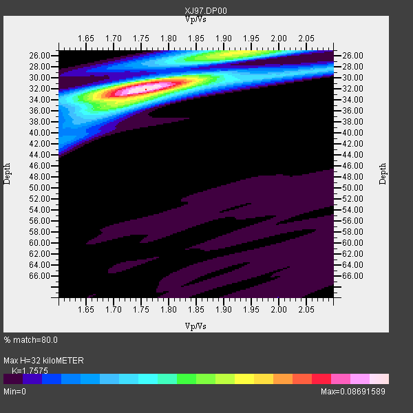
| Crust2 Type: | M7,medium thick extended crust, 0.5 km seds. |
| Thickness Estimate: | 32 km |
| Thickness StdDev: | 1.2 km |
| Vp/Vs Estimate: | 1.76 |
| Vp/Vs StdDev: | 0.03 |
| Vs Estimate: | 3.572 km/s |
| Poisson's Ratio: | 0.26 |
| Peak Value: | 0.09 |
| Assumed Vp: | 6.279 km/s |
| Ps Weight: | 0.33333334 |
| PpPs Weight: | 0.33333334 |
| PsPs Weight: | 0.33333328 |
| Residual Complexity: | 0.494 |
| Nearby stations H: | +- |
| (2.0 deg) Vp/Vs: | +- |
4 with match > 90% ( 17.391304 %) and 13 with match > 80% ( 56.52174 %) out of 23.
Download stack as xyz text file.
Azimuth Distribution of Events:

Prior Results for this Station
| Study | Thickness | Vp/Vs | Vp | Vs | Poissons Ratio | Extra |
| EARS | 32 km | 1.76 | 6.279 km/s | 3.572 km/s | 0.26 | |
| Crust2.0 | 35 km | 1.78 | 6.279 km/s | 3.533 km/s | 0.27 | M7,medium thick extended crust, 0.5 km seds. |
| Global Maxima | 32 km | 1.76 | 6.279 km/s | 3.572 km/s | 0.26 | amp=0.08691589 |
| Local Maxima 1 | 25 km | 1.93 | 6.279 km/s | 3.257 km/s | 0.32 | amp=0.051900733 |
| Local Maxima 2 | 31 km | 1.75 | 6.279 km/s | 3.588 km/s | 0.26 | amp=0.03418584 |
| Local Maxima 3 | 34 km | 1.73 | 6.279 km/s | 3.634 km/s | 0.25 | amp=0.025698632 |
| Local Maxima 4 | 25 km | 1.88 | 6.279 km/s | 3.344 km/s | 0.30 | amp=0.012118975 |
| Predicted Arrivals for vertical incidence (zero ray parameter) | |
| Ps | 3.86 SECOND |
| PpPs | 14.05 SECOND |
| PsPs/PpSs | 17.91 SECOND |
Events Processed for this Station
Download zip of receiver functions as SAC
Plot maxima for each earthquake.
Events Used in the Stack
(13 events)| Radial Match | Distance | Baz | FERegion | Time | Lat/Lon | Depth | Magnitude |
| 95.43173 | 79.8 deg | 140.75 deg | Near Coast Of Central Chile | 1997/10/15 01:03:33 GMT | (-30.9, -71.2) | 58 km | 6.8 MB, 6.8 MS, 7.3 UNKNOWN, 7.1 MW |
| 95.15692 | 80.5 deg | 233.79 deg | South Of Fiji Islands | 1997/10/14 09:53:18 GMT | (-22.1, -176.8) | 167 km | 6.7 MB, 7.7 UNKNOWN, 7.4 ME |
| 94.413055 | 78.8 deg | 140.685 deg | Near Coast Of Central Chile | 1997/07/06 09:54:00 GMT | (-30.1, -71.9) | 19 km | 5.8 MB, 6.5 MS, 6.8 UNKNOWN, 6.4 ME |
| 91.76514 | 45.6 deg | 309.447 deg | Andreanof Islands, Aleutian Is. | 1997/06/17 21:03:40 GMT | (51.3, -179.3) | 33 km | 6.4 MB, 6.3 MS, 6.4 UNKNOWN, 6.6 ML |
| 89.08669 | 84.4 deg | 293.488 deg | Volcano Islands, Japan Region | 1997/07/28 06:46:55 GMT | (22.4, 142.7) | 33 km | 5.7 MB, 5.8 MS, 5.9 UNKNOWN, 5.9 MW |
| 88.77086 | 69.3 deg | 57.182 deg | Azores Islands, Portugal | 1997/06/27 04:39:52 GMT | (38.3, -26.7) | 10 km | 5.6 MB, 5.4 MS, 5.9 UNKNOWN, 5.9 MW |
| 88.02814 | 76.3 deg | 132.199 deg | Jujuy Province, Argentina | 1997/07/20 10:14:22 GMT | (-23.0, -66.3) | 256 km | 5.7 MB, 6.1 UNKNOWN, 5.7 ME |
| 86.91987 | 38.3 deg | 311.188 deg | Fox Islands, Aleutian Islands | 1997/07/20 00:30:20 GMT | (52.6, -167.5) | 14 km | 5.6 MB, 5.9 MS, 6.2 UNKNOWN, 6.2 MW |
| 86.89787 | 78.5 deg | 232.7 deg | Tonga Islands | 1997/09/10 12:57:07 GMT | (-21.3, -174.4) | 10 km | 5.7 MB, 6.1 MS, 6.1 UNKNOWN, 5.9 MW |
| 84.76487 | 70.1 deg | 309.376 deg | Kuril Islands | 1997/07/14 16:09:35 GMT | (43.2, 146.4) | 33 km | 5.9 MB, 5.8 MS, 6.1 UNKNOWN, 5.8 ME |
| 83.748924 | 41.9 deg | 161.99 deg | Central East Pacific Rise | 1997/08/15 07:37:49 GMT | (-4.4, -105.7) | 10 km | 5.3 MB, 5.8 MS, 6.2 UNKNOWN, 6.1 MW |
| 81.21627 | 86.8 deg | 233.727 deg | South Of Fiji Islands | 1997/09/04 04:23:37 GMT | (-26.6, 178.3) | 625 km | 6.3 MB, 6.8 UNKNOWN, 6.5 ME |
| 80.94234 | 50.3 deg | 119.91 deg | Colombia | 1997/09/02 12:13:22 GMT | (3.8, -75.7) | 199 km | 6.5 MB, 6.8 UNKNOWN, 6.4 ME |
Losers
(10 events)| Radial Match | Distance | Baz | FERegion | Time | Lat/Lon | Depth | Magnitude | Reason |
| 79.50787 | 33.2 deg | 119.332 deg | Caribbean Sea | 1997/07/06 20:13:37 GMT | (16.2, -87.9) | 33 km | 5.5 MB, 5.5 MS, 6.0 UNKNOWN, 5.9 MW | |
| 75.9715 | 78.2 deg | 140.082 deg | Near Coast Of Central Chile | 1997/07/19 12:22:57 GMT | (-29.3, -71.7) | 26 km | 5.8 MB, 5.5 MS, 5.9 UNKNOWN, 5.8 MW | |
| 67.42347 | 83.6 deg | 294.664 deg | Volcano Islands, Japan Region | 1997/07/08 02:24:07 GMT | (23.8, 142.7) | 33 km | 5.8 MB, 5.6 MS, 5.9 UNKNOWN, 5.8 MW | |
| 65.23003 | 80.3 deg | 235.389 deg | Fiji Islands Region | 1997/08/25 11:59:00 GMT | (-20.8, -177.8) | 394 km | 5.5 UNKNOWN, 5.3 MB | |
| 62.953793 | 94.6 deg | 305.513 deg | Southwestern Ryukyu Isl., Japan | 1997/08/13 04:45:04 GMT | (25.0, 125.8) | 55 km | 6.0 MB, 5.6 MS, 6.1 UNKNOWN, 6.1 MW | |
| 62.26941 | 44.7 deg | 309.449 deg | Andreanof Islands, Aleutian Is. | 1997/10/15 03:11:09 GMT | (51.4, -177.9) | 22 km | 5.7 MB, 6.1 MS, 6.3 UNKNOWN, 5.6 ML | |
| 58.109184 | 88.4 deg | 227.916 deg | Kermadec Islands Region | 1997/10/07 13:15:53 GMT | (-31.8, -178.3) | 33 km | 5.5 MB, 5.6 MS | |
| 57.988403 | 85.6 deg | 177.988 deg | Southern East Pacific Rise | 1997/06/26 19:21:08 GMT | (-49.7, -114.6) | 10 km | 5.4 MB, 6.0 MS, 6.2 UNKNOWN, 6.1 MW | |
| 44.958366 | 97.0 deg | 307.403 deg | Taiwan Region | 1997/07/15 11:05:31 GMT | (24.7, 122.4) | 103 km | 5.6 MB, 5.6 UNKNOWN, 5.6 MW | |
| 42.773773 | 91.8 deg | 263.923 deg | Solomon Islands | 1997/09/07 12:57:06 GMT | (-6.0, 154.5) | 421 km | 5.6 MB, 5.8 UNKNOWN, 5.8 MW |
