
Station XJ HVY - Hills Valley
Network: XJ97 - Sierran Paradox
Nearby stations (2 deg radius)
| Station | Name | (Lat, Lon) | Start / End | Elevation |
| HVY | Hills Valley | (36.70, -119.32) | 1997-05-29 / 1997-12-31 | 193 m |
| Crust2 Type: | M9,thick extended crust, 0.5 km seds. |
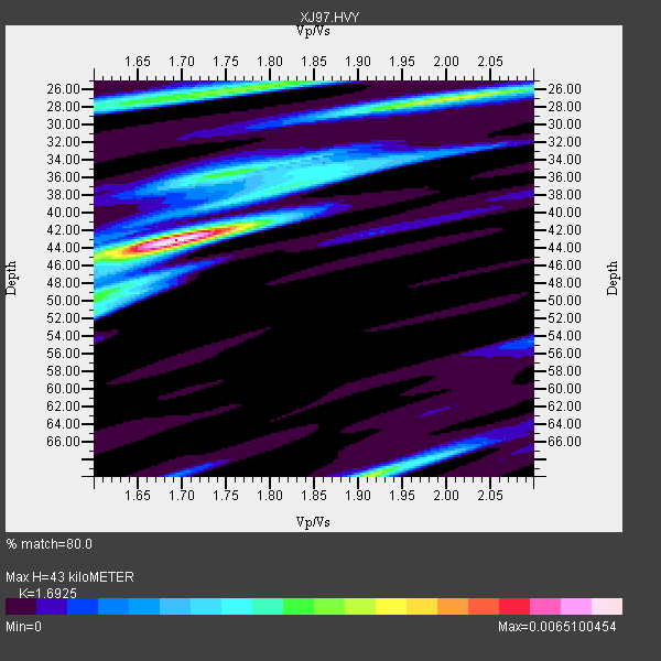
| Thickness Estimate: | 43 km |
| Thickness StdDev: | 12 km |
| Vp/Vs Estimate: | 1.69 |
| Vp/Vs StdDev: | 0.11 |
| Vs Estimate: | 3.717 km/s |
| Poisson's Ratio: | 0.23 |
| Peak Value: | 0.01 |
| Assumed Vp: | 6.291 km/s |
| Ps Weight: | 0.33333334 |
| PpPs Weight: | 0.33333334 |
| PsPs Weight: | 0.33333328 |
| Residual Complexity: | 0.679 |
| Nearby stations H: | +- |
| (2.0 deg) Vp/Vs: | +- |
4 with match > 90% ( 14.814815 %) and 9 with match > 80% ( 33.333332 %) out of 27.
Download stack as xyz text file.
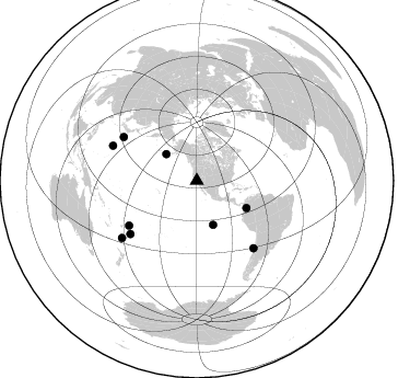
Azimuth Distribution of Events:
Prior Results for this Station
| Study | Thickness | Vp/Vs | Vp | Vs | Poissons Ratio | Extra |
| EARS | 43 km | 1.69 | 6.291 km/s | 3.717 km/s | 0.23 | |
| Crust2.0 | 40 km | 1.78 | 6.291 km/s | 3.539 km/s | 0.27 | M9,thick extended crust, 0.5 km seds. |
| Global Maxima | 43 km | 1.69 | 6.291 km/s | 3.717 km/s | 0.23 | amp=0.0065100454 |
| Local Maxima 1 | 70 km | 1.91 | 6.291 km/s | 3.29 km/s | 0.31 | amp=0.0039009599 |
| Local Maxima 2 | 27 km | 2.00 | 6.291 km/s | 3.146 km/s | 0.33 | amp=0.0038895628 |
| Local Maxima 3 | 26 km | 1.77 | 6.291 km/s | 3.549 km/s | 0.27 | amp=0.003508382 |
| Local Maxima 4 | 36 km | 1.75 | 6.291 km/s | 3.605 km/s | 0.26 | amp=0.002574934 |
| Predicted Arrivals for vertical incidence (zero ray parameter) | |
| Ps | 4.73 SECOND |
| PpPs | 18.40 SECOND |
| PsPs/PpSs | 23.14 SECOND |
Events Processed for this Station
Download zip of receiver functions as SAC
Plot maxima for each earthquake.
Events Used in the Stack
(9 events)| Radial Match | Distance | Baz | FERegion | Time | Lat/Lon | Depth | Magnitude |
| 94.94381 | 74.0 deg | 236.617 deg | Tonga Islands | 1997/08/29 06:54:00 GMT | (-15.2, -175.6) | 33 km | 5.6 MB, 6.4 MS, 6.5 UNKNOWN, 6.4 MW |
| 91.84226 | 37.0 deg | 310.915 deg | Fox Islands, Aleutian Islands | 1997/07/20 00:30:20 GMT | (52.6, -167.5) | 14 km | 5.6 MB, 5.9 MS, 6.2 UNKNOWN, 6.2 MW |
| 91.83912 | 86.0 deg | 232.674 deg | South Of Fiji Islands | 1997/09/04 04:23:37 GMT | (-26.6, 178.3) | 625 km | 6.3 MB, 6.8 UNKNOWN, 6.5 ME |
| 90.02497 | 83.0 deg | 292.519 deg | Volcano Islands, Japan Region | 1997/07/28 06:46:55 GMT | (22.4, 142.7) | 33 km | 5.7 MB, 5.8 MS, 5.9 UNKNOWN, 5.9 MW |
| 86.50386 | 77.7 deg | 231.472 deg | Tonga Islands | 1997/09/10 12:57:07 GMT | (-21.3, -174.4) | 10 km | 5.7 MB, 6.1 MS, 6.1 UNKNOWN, 5.9 MW |
| 85.9474 | 80.3 deg | 139.835 deg | Near Coast Of Central Chile | 1997/07/27 05:21:29 GMT | (-30.5, -71.9) | 33 km | 5.6 MB, 5.8 MS, 6.3 UNKNOWN, 6.2 MW |
| 85.458664 | 51.6 deg | 118.708 deg | Colombia | 1997/09/02 12:13:22 GMT | (3.8, -75.7) | 199 km | 6.5 MB, 6.8 UNKNOWN, 6.4 ME |
| 82.62724 | 42.8 deg | 159.782 deg | Central East Pacific Rise | 1997/08/15 07:37:49 GMT | (-4.4, -105.7) | 10 km | 5.3 MB, 5.8 MS, 6.2 UNKNOWN, 6.1 MW |
| 80.20504 | 77.9 deg | 300.801 deg | Southeast Of Honshu, Japan | 1997/09/30 06:27:24 GMT | (32.0, 141.9) | 10 km | 5.5 MB, 6.5 MS, 6.1 UNKNOWN, 6.0 MW |
Losers
(18 events)| Radial Match | Distance | Baz | FERegion | Time | Lat/Lon | Depth | Magnitude | Reason |
| 93.58196 | 44.3 deg | 308.971 deg | Andreanof Islands, Aleutian Is. | 1997/06/17 21:03:40 GMT | (51.3, -179.3) | 33 km | 6.4 MB, 6.3 MS, 6.4 UNKNOWN, 6.6 ML | |
| 93.103096 | 79.9 deg | 139.563 deg | Near Coast Of Central Chile | 1997/07/06 09:54:00 GMT | (-30.1, -71.9) | 19 km | 5.8 MB, 6.5 MS, 6.8 UNKNOWN, 6.4 ME | |
| 85.26968 | 68.8 deg | 308.583 deg | Kuril Islands | 1997/07/14 16:09:35 GMT | (43.2, 146.4) | 33 km | 5.9 MB, 5.8 MS, 6.1 UNKNOWN, 5.8 ME | |
| 79.22561 | 80.2 deg | 139.832 deg | Near Coast Of Central Chile | 1997/07/25 06:47:02 GMT | (-30.5, -71.9) | 33 km | 5.6 MB, 5.5 MS, 6.3 UNKNOWN | |
| 73.73225 | 72.9 deg | 170.507 deg | Southern East Pacific Rise | 1997/06/10 21:53:55 GMT | (-35.8, -108.1) | 10 km | 5.8 MB, 6.1 MS, 6.5 UNKNOWN, 5.8 MS | |
| 70.860115 | 83.3 deg | 308.099 deg | Western Honshu, Japan | 1997/06/25 09:50:12 GMT | (34.4, 131.6) | 10 km | 5.5 MB, 5.6 MS, 5.9 UNKNOWN, 5.8 MW | |
| 70.4838 | 79.4 deg | 234.206 deg | Fiji Islands Region | 1997/08/25 11:59:00 GMT | (-20.8, -177.8) | 394 km | 5.5 UNKNOWN, 5.3 MB | |
| 68.67944 | 81.5 deg | 231.806 deg | South Of Fiji Islands | 1997/06/11 09:29:23 GMT | (-24.0, -177.5) | 164 km | 5.9 UNKNOWN, 5.4 MB, 5.5 MB | |
| 66.62603 | 73.8 deg | 236.452 deg | Tonga Islands | 1997/08/04 18:53:58 GMT | (-15.2, -175.3) | 33 km | 5.5 MB, 6.0 MS, 6.1 UNKNOWN, 6.0 MW | |
| 65.27609 | 85.3 deg | 233.432 deg | South Of Fiji Islands | 1997/08/26 15:22:09 GMT | (-25.5, 178.3) | 610 km | 5.5 MB, 5.7 UNKNOWN | |
| 63.40101 | 77.6 deg | 131.088 deg | Jujuy Province, Argentina | 1997/07/20 10:14:22 GMT | (-23.0, -66.3) | 256 km | 5.7 MB, 6.1 UNKNOWN, 5.7 ME | |
| 61.469883 | 78.0 deg | 237.059 deg | Fiji Islands Region | 1997/06/11 11:53:32 GMT | (-17.8, -178.8) | 573 km | 5.5 UNKNOWN, 4.9 MB | |
| 60.75732 | 82.2 deg | 293.702 deg | Volcano Islands, Japan Region | 1997/07/08 02:24:07 GMT | (23.8, 142.7) | 33 km | 5.8 MB, 5.6 MS, 5.9 UNKNOWN, 5.8 MW | |
| 59.21104 | 93.3 deg | 304.504 deg | Southwestern Ryukyu Isl., Japan | 1997/08/13 04:45:04 GMT | (25.0, 125.8) | 55 km | 6.0 MB, 5.6 MS, 6.1 UNKNOWN, 6.1 MW | |
| 55.75661 | 90.5 deg | 262.954 deg | Solomon Islands | 1997/09/07 12:57:06 GMT | (-6.0, 154.5) | 421 km | 5.6 MB, 5.8 UNKNOWN, 5.8 MW | |
| 53.20657 | 95.6 deg | 306.372 deg | Taiwan Region | 1997/07/15 11:05:31 GMT | (24.7, 122.4) | 103 km | 5.6 MB, 5.6 UNKNOWN, 5.6 MW | |
| 47.55058 | 79.4 deg | 138.956 deg | Near Coast Of Central Chile | 1997/07/19 12:22:57 GMT | (-29.3, -71.7) | 26 km | 5.8 MB, 5.5 MS, 5.9 UNKNOWN, 5.8 MW | |
| 25.871025 | 70.4 deg | 308.006 deg | Hokkaido, Japan Region | 1997/10/08 21:20:59 GMT | (41.9, 144.8) | 33 km | 5.5 MB, 5.6 MS, 5.9 UNKNOWN, 5.9 MW |
