
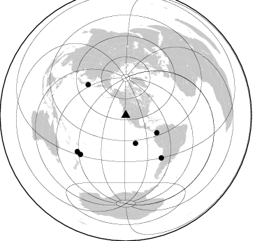
Station XJ JUN - Junction Meadow (Kern)
Network: XJ97 - Sierran Paradox
Nearby stations (2 deg radius)

| Station | Name | (Lat, Lon) | Start / End | Elevation |
| JUN | Junction Meadow (Kern) | (36.58, -118.41) | 1997-06-20 / 1997-12-31 | 2471 m |
| Crust2 Type: | M9,thick extended crust, 0.5 km seds. |
| Thickness Estimate: | 31 km |
| Thickness StdDev: | 6.7 km |
| Vp/Vs Estimate: | 1.92 |
| Vp/Vs StdDev: | 0.13 |
| Vs Estimate: | 3.272 km/s |
| Poisson's Ratio: | 0.31 |
| Peak Value: | 0.03 |
| Assumed Vp: | 6.291 km/s |
| Ps Weight: | 0.33333334 |
| PpPs Weight: | 0.33333334 |
| PsPs Weight: | 0.33333328 |
| Residual Complexity: | 0.586 |
| Nearby stations H: | +- |
| (2.0 deg) Vp/Vs: | +- |
4 with match > 90% ( 26.666666 %) and 6 with match > 80% ( 40.0 %) out of 15.
Download stack as xyz text file.
Azimuth Distribution of Events:
Prior Results for this Station
| Study | Thickness | Vp/Vs | Vp | Vs | Poissons Ratio | Extra |
| EARS | 31 km | 1.92 | 6.291 km/s | 3.272 km/s | 0.31 | |
| Crust2.0 | 40 km | 1.78 | 6.291 km/s | 3.539 km/s | 0.27 | M9,thick extended crust, 0.5 km seds. |
| Global Maxima | 31 km | 1.92 | 6.291 km/s | 3.272 km/s | 0.31 | amp=0.031203236 |
| Local Maxima 1 | 25 km | 1.61 | 6.291 km/s | 3.902 km/s | 0.19 | amp=0.026981492 |
| Local Maxima 2 | 38 km | 1.80 | 6.291 km/s | 3.5 km/s | 0.28 | amp=0.014713092 |
| Local Maxima 3 | 50 km | 1.60 | 6.291 km/s | 3.932 km/s | 0.18 | amp=0.010774991 |
| Local Maxima 4 | 66 km | 1.93 | 6.291 km/s | 3.251 km/s | 0.32 | amp=0.00876942 |
| Predicted Arrivals for vertical incidence (zero ray parameter) | |
| Ps | 4.58 SECOND |
| PpPs | 14.52 SECOND |
| PsPs/PpSs | 19.10 SECOND |
Events Processed for this Station
Download zip of receiver functions as SAC
Plot maxima for each earthquake.
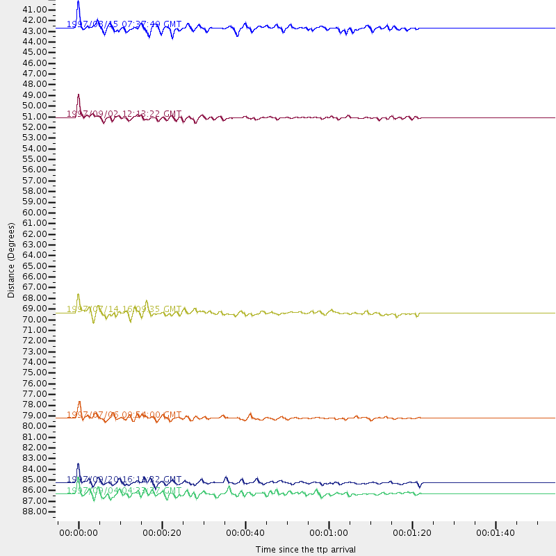
Events Used in the Stack
(6 events)| Radial Match | Distance | Baz | FERegion | Time | Lat/Lon | Depth | Magnitude |
| 95.52718 | 79.4 deg | 140.188 deg | Near Coast Of Central Chile | 1997/07/06 09:54:00 GMT | (-30.1, -71.9) | 19 km | 5.8 MB, 6.5 MS, 6.8 UNKNOWN, 6.4 ME |
| 92.12483 | 85.5 deg | 229.214 deg | Kermadec Islands Region | 1997/09/20 16:11:32 GMT | (-28.7, -177.6) | 30 km | 6.1 MB, 7.0 MS, 7.2 UNKNOWN, 6.7 ME |
| 90.42351 | 69.4 deg | 308.983 deg | Kuril Islands | 1997/07/14 16:09:35 GMT | (43.2, 146.4) | 33 km | 5.9 MB, 5.8 MS, 6.1 UNKNOWN, 5.8 ME |
| 90.05244 | 86.5 deg | 233.247 deg | South Of Fiji Islands | 1997/09/04 04:23:37 GMT | (-26.6, 178.3) | 625 km | 6.3 MB, 6.8 UNKNOWN, 6.5 ME |
| 89.7328 | 50.9 deg | 119.444 deg | Colombia | 1997/09/02 12:13:22 GMT | (3.8, -75.7) | 199 km | 6.5 MB, 6.8 UNKNOWN, 6.4 ME |
| 84.74689 | 42.4 deg | 161.021 deg | Central East Pacific Rise | 1997/08/15 07:37:49 GMT | (-4.4, -105.7) | 10 km | 5.3 MB, 5.8 MS, 6.2 UNKNOWN, 6.1 MW |
Losers
(9 events)| Radial Match | Distance | Baz | FERegion | Time | Lat/Lon | Depth | Magnitude | Reason |
| 79.14599 | 37.6 deg | 310.949 deg | Fox Islands, Aleutian Islands | 1997/07/20 00:30:20 GMT | (52.6, -167.5) | 14 km | 5.6 MB, 5.9 MS, 6.2 UNKNOWN, 6.2 MW | |
| 77.97296 | 77.0 deg | 131.714 deg | Jujuy Province, Argentina | 1997/07/20 10:14:22 GMT | (-23.0, -66.3) | 256 km | 5.7 MB, 6.1 UNKNOWN, 5.7 ME | |
| 64.34395 | 80.0 deg | 234.839 deg | Fiji Islands Region | 1997/08/25 11:59:00 GMT | (-20.8, -177.8) | 394 km | 5.5 UNKNOWN, 5.3 MB | |
| 62.239502 | 85.8 deg | 234.011 deg | South Of Fiji Islands | 1997/08/26 15:22:09 GMT | (-25.5, 178.3) | 610 km | 5.5 MB, 5.7 UNKNOWN | |
| 59.25425 | 82.9 deg | 294.215 deg | Volcano Islands, Japan Region | 1997/07/08 02:24:07 GMT | (23.8, 142.7) | 33 km | 5.8 MB, 5.6 MS, 5.9 UNKNOWN, 5.8 MW | |
| 59.110134 | 78.9 deg | 139.585 deg | Near Coast Of Central Chile | 1997/07/19 12:22:57 GMT | (-29.3, -71.7) | 26 km | 5.8 MB, 5.5 MS, 5.9 UNKNOWN, 5.8 MW | |
| 49.29484 | 91.2 deg | 263.489 deg | Solomon Islands | 1997/09/07 12:57:06 GMT | (-6.0, 154.5) | 421 km | 5.6 MB, 5.8 UNKNOWN, 5.8 MW | |
| 44.562656 | 91.9 deg | 186.045 deg | Pacific-Antarctic Ridge | 1997/09/03 06:22:44 GMT | (-55.2, -129.0) | 10 km | 5.1 MB, 6.0 MS, 6.1 UNKNOWN, 6.0 MW | |
| 43.43396 | 96.3 deg | 306.945 deg | Taiwan Region | 1997/07/15 11:05:31 GMT | (24.7, 122.4) | 103 km | 5.6 MB, 5.6 UNKNOWN, 5.6 MW |
